
OS grid reference SN217438 Country Wales Postcode district SA43 Local time Thursday 12:05 PM | Sovereign state United Kingdom Police Dyfed-Powys Dialling code 01239 Post town Ceredigion | |
 | ||
Weather 8°C, Wind NE at 27 km/h, 84% Humidity | ||
Strange lights over llechryd in cardigan west wales 08 08 09
Llechryd ([ɬɛxrɪd]) is a village on the A484 road approximately 3 miles (4.8 km) from Cardigan, in Ceredigion, Wales. It is part of the Community of Llangoedmor.
Contents
- Strange lights over llechryd in cardigan west wales 08 08 09
- Map of Llechryd Cardigan UK
- Hywel dda ysgol gynradd llechryd
- Etymology
- Situation
- History
- Llechryd Bridge
- Teifi Trout Association
- References
Map of Llechryd, Cardigan, UK
Hywel dda ysgol gynradd llechryd
Etymology
The name Llechryd derives from the Welsh for "Slate Ford" ("Llech + Rhyd"). As Llechryd is the first point on the river Teifi to the East of Cardigan where, due to the gorge at Cilgerran, crossing is possible, it is perfectly feasible that such a crossing existed prior to the building of the bridge. The position of the hypothetical ford is unknown.
Situation
The village is approximately two miles long. Within it, and nearby, are situated businesses, recreational facilities, a school, and religious buildings including:
The canal was not a transport canal rather a conduit for fresh water to a tinworks which stood behind the Castell Malgwyn stable block on the southern bank of the river Teifi.
The river Teifi is tidal and was navigable by lighters as far as Llechryd until the 1840s, when careless working of the slate quarries resulted in severe choking of the Cilgerran Gorge, causing the flooding for which the area is now known and moving the navigable (in all but the smallest boats/canoes) tidal limit downstream of Cilgerran Castle.
Most of the village has been built along the A484 going down into the valley, although some estates branch off the road.
There is a, now disused, mill and associated buildings on the Nant Arberth. These buildings are now residential properties. Much closer to the Teifi, but still on the Nant Arberth below Glanarberth, are the remains of a much older mill. The only evidence left is a platform area for a building, and the remains of a dam like structure with a water channel.
Due to the village's closeness to the Port of Cardigan, many large houses were built nearby by wealthy merchants and Sea Captains. These include Cilbronnau, Noyadd Wilym, Coedmore, Glanolmarch, Pengraig, Castell Malgwyn, Glanarberth, Manor Eifed, Penylan, Llwynduris, Blaen-Pant, and Stradmore.
History
A battle was fought in or near the town in 1087 between Rhys ab Twdwr and the sons of Bleddin ab Cynfyn. In 1844, during the Rebecca Riots, the weir across the river which had prevented salmon from going upstream was demolished by rioters.
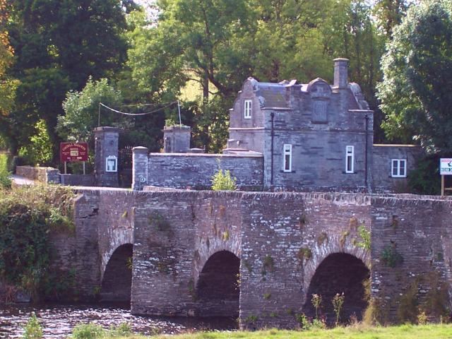
Llechryd Bridge
The River Teifi is crossed at Llechryd by a grade II* listed bridge built in the 17th century which was damaged in 2005 by a large flood. The bridge, part of an ancient drovers' road, can be wholly submerged by the river at times of high flood, and inhabitants wishing to cross the river have to go via Cardigan or Cenarth. A bridge at Llechryd is marked on Christopher Saxton's map of 'Radnor, Brecknok, Cardigan et Caermarden' of 1579, on which the Village is marked as 'Capel Langbrid'.
Teifi Trout Association
The Teifi Trout Association (TTA) owns the trout fishing rights from the eastern side of the bridge upwards, although some plots of land by the river are privately owned.