
Website www.co.patrick.va.us Founded 1791 | Area 1,259 km² Population 18,368 (2013) Cities Stuart | |
 | ||
Points of interest Villa Appalaccia Winery, Wood Brothers Racing M, ToyTime Museum, The Saddle Overlook, Dehart Botanical Gardens | ||
Patrick County is a county located in the Commonwealth of Virginia. As of the 2010 census, the population was 18,490. Its county seat is Stuart. It is located within both the rolling hills and valleys of the Piedmont Region of Virginia and mountainous Southwest Virginia.
Contents
- Map of Patrick County VA USA
- History
- Geography
- Adjacent counties
- National protected areas
- Major highways
- Demographics
- Distinctions
- Tourism
- Education
- Town
- Census designated place
- Notable residents
- References
Map of Patrick County, VA, USA
History
Patrick County was formed in 1791, when Patrick Henry County was divided into Patrick County and Henry County. Patrick Henry County was named for Patrick Henry, and was formed in 1777.
Prior to the formation of Patrick County, one of the Virginia colony's first frontier forts lay within the boundaries of what was then Halifax County on the banks of the North Mayo River. The location of Fort Mayo, now marked by a Virginia state historic marker, lies within present-day Patrick County. It was one of a number of such forts built from the Potomac River south to North Carolina, and was commanded by Captain Samuel Harris in 1756, the year in which George Washington made a tour of Fort Mayo and several other forts on the Virginia frontier. Fort Mayo was the southernmost of the Virginia frontier forts and saw action during the French and Indian War.
One of Patrick County's most prominent early settlers was Col. Abraham Penn (sometimes written Abram Penn), born in 1743 in what is today Amherst County, Virginia. Penn qualified as Lieutenant in the Amherst County militia in June 1768, and led a company under Col. Andrew Lewis at the Battle of Point Pleasant in 1774. Penn later moved with his wife Ruth (née Stovall) to present-day Henry County, Virginia, where he patented lands at the later site of Beaver Creek Plantation. Penn served on the Committee of Safety for both Henry and Pittsylvania counties, and as a delegate to the Virginia General Assembly from Henry County.
Eventually selling those lands to the Hairston family, Penn moved with his family a few miles farther west to what is today Patrick County, where he built his home Poplar Grove. During the American Revolution Col. Penn ordered the muster of some 300 militiamen under his command to march south to aid General Nathanael Greene at the battle of Guilford Court House, although some question whether the troops arrived in time for the fighting. Militia under Penn's command were also involved in the Battle of Eutaw Springs. Penn was later present at Yorktown to witness the surrender of the British forces under General Cornwallis. Col. Penn was one of the organizers of Patrick County, which he served many years as a justice. The unincorporated community of Penn's Store is named for Col. Penn and his descendants. The Abram Penn Highway in Patrick County is also named for Col. Penn, who died in 1801.
Geography
According to the U.S. Census Bureau, the county has a total area of 486 square miles (1,260 km2), of which 483 square miles (1,250 km2) is land and 2.8 square miles (7.3 km2) (0.6%) is water.
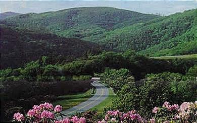
Patrick County has two defined physiographic provinces lying within its boundaries. One-third of Patrick County is in the rolling Piedmont region, and the remaining two-thirds are in the picturesque Blue Ridge Mountains, where the Blue Ridge Parkway forms the county's western border with Carroll and Floyd counties to the north.
Adjacent counties
National protected areas
Major highways
Demographics
As of the 2010 census, there were 18,490 people, 8,081 households, and 5,410 families residing in the county. The population density was 40 people per square mile (16/km²). There were 10,083 housing units at an average density of 20 per square mile (8/km²). The racial makeup of the county was 91.10% White, 5.9% Black or African American, 0.30% Native American, 0.20% Asian, 0.00% Pacific Islander, 1.40% from other races, and 1.10% from two or more races. 2.40% of the population were Hispanic or Latino of any race.
As of the 2000 Census, there were 8,141 households out of which 28.50% had children under the age of 18 living with them, 58.90% were married couples living together, 8.60% had a female householder with no husband present, and 28.60% were non-families. 25.80% of all households were made up of individuals and 11.40% had someone living alone who was 65 years of age or older. The average household size was 2.36 and the average family size was 2.81.
In the county, the population was spread out with 21.70% under the age of 18, 7.10% from 18 to 24, 28.00% from 25 to 44, 26.70% from 45 to 64, and 16.50% who were 65 years of age or older. The median age was 40 years. For every 100 females there were 96.90 males. For every 100 females age 18 and over, there were 94.90 males.
The median income for a household in the county was $28,705, and the median income for a family was $36,232. Males had a median income of $25,391 versus $18,711 for females. The per capita income for the county was $15,574. About 9.60% of families and 13.40% of the population were below the poverty line, including 15.40% of those under age 18 and 18.00% of those age 65 or over.
Distinctions
Part of the Rocky Knob American Viticultural Area, as defined by the federal government, is located in Patrick County. Patrick County was also a setting for the ministry of Reverend Bob Childress whose life was chronicled in the book "The Man Who Moved a Mountain".
Tourism
Patrick County is one of the great tourist areas of Virginia. The county has two of Virginia's eight remaining covered bridges (one of which washed away in September 2015), rises from 900 feet to well over 3,000 feet, providing panoramic views. Patrick County is Virginia's Gateway to the Blue Ridge Parkway, and is only minutes from Mabry Mill, the most photographed destination on the parkway. It is also the home of Fairy Stone State Park.The county hosts the longest running beach music festival on the East coast, is home to the legendary NASCAR team the Wood Brothers, and many more attractions each year provide a wide range of activities for every group of every age.
Patrick County is featured on the Virginia is For Lovers website.
The Bob White Covered Bridge once located in Woolwine washed away by Flood Waters in September, 2015. Bob White Covered Bridge Washes Away
Education
Patrick County Public Schools has seven total public schools, of which four are for grades K-7, one is for grades K-3, one is for grades 4-7, and Patrick County High School is for grade 8-12. One school, Stuart Elementary was recognized in 2008 as receiving the Governor's VIP award. Recently two schools, Stuart Elementary and Woolwine Elementary were designated as Distinguished Title I schools. In 2006, Patrick County Public Schools was listed as an outperforming school district, one of 12 in the state of Virginia, by Standard and Poor's. All of the schools have received "full accreditation" status by the State of Virginia and all schools have met Adequate Yearly Progress (AYP) status as defined by the No Child Left Behind Act of 2001.