
Founded 1771 Congressional district 6th Website www.co.surry.nc.us Population 73,050 (2013) | Area 1,388 km² | |
 | ||
Points of interest Andy Griffith Museum, Pilot Mountain, Mt Airy Museum of Regional, Old North State Winery, Riverside Park Destinations | ||
Surry County is a county located in the U.S. state of North Carolina. As of the 2010 census, the population was 73,673. Its county seat is Dobson, and its largest city is Mount Airy.
Contents
- Map of Surry County NC USA
- History
- Geography
- Mountains
- Rivers
- National protected area
- Demographics
- Law and government
- Education
- High schools
- Middle schools
- Elementary schools
- Mount Airy City Schools
- Elkin City Schools
- Colleges and universities
- Broadcast
- Airports
- City
- Towns
- Census designated places
- Unincorporated communities
- References
Map of Surry County, NC, USA
Surry county comprises the Mount Airy, NC Micropolitan Statistical Area, which is also included in the Greensboro-Winston-Salem-High Point, NC Combined Statistical Area.
History
The county was formed in 1771 from Rowan County. It was named for the county of Surrey in England, birthplace of William Tryon, Governor of North Carolina from 1765 to 1771.
In 1777 parts of Surry County and Washington District (now Washington County, Tennessee) were combined to form Wilkes County. The first permanent courthouse was established at Richmond in 1779, what is now the modern-day Old Richmond Township in Forsyth County near Donnaha. However, in 1789 the eastern half of Surry County became Stokes County, thus making the Richmond site unusable for either county. In 1790, the county seat was moved to Rockford where it remained for over half a century. In 1850 the half of the county's remaining territory south of the Yadkin River became Yadkin County. The town of Dobson was established in 1853 to be the new county seat.
Geography
According to the U.S. Census Bureau, the county has a total area of 536 square miles (1,390 km2), of which 532 square miles (1,380 km2) is land and 4.1 square miles (11 km2) (0.8%) is water.
The whole county is generally considered part of the Piedmont Triad metropolitan area. Surry County is located in the Yadkin Valley AVA, an American Viticultural Area. Wines made from grapes grown in Surry County may carry the appellation Yadkin Valley on their label.
Mountains
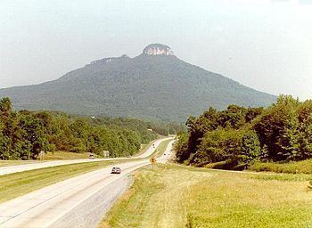
Surry County is located both within the Piedmont region of central North Carolina and in the Appalachian Mountains region of western North Carolina. Most of the eastern two-thirds of the county lies within the Piedmont, a region of gently rolling hills and valleys. However, the Piedmont of Surry County also contains a small portion of the Sauratown Mountains; Surry County marks the western end of the Sauratown Mountain range. The western third of the county lies within the Blue Ridge Mountains, and they dominate the county's western horizon. The mountain passes (called "gaps" locally) are notorious for their occasional high winds, which can force automobiles and even large Eighteen wheeler trucks off the highways which lead through the passes. As a result, high wind advisories issued by the National Weather Service are not uncommon. The highest point in Surry County is Fisher Peak in the Blue Ridge; it rises to 3,570 feet (1,088 m) above sea level. However, the best-known peak in Surry County is not the highest. That honor goes to Pilot Mountain, an isolated monadnock and a North Carolina landmark. Pilot Mountain sharply rises some 2,421 feet (738 m) above the surrounding countryside, and can be seen for miles.
Another notable peak in Surry County is Cumberland Knob, in the northwest corner of the county, which was the starting point of the construction of the Blue Ridge Parkway. The following table provides a list of some of the more prominent mountains of the county.
Rivers
While there are many creeks and streams in Surry County, there are three recognized major rivers in the county, the Ararat, the Fisher, and the Mitchell. All three flow southward and are tributaries of the Yadkin River, which forms the southern border of Surry County. The Yadkin River is the northern component of the Pee Dee River which flows to the Atlantic Ocean near Georgetown, South Carolina.
National protected area
Demographics
As of the census of 2000, there were 71,219 people, 28,408 households, and 20,482 families residing in the county. The population density was 133 people per square mile (51/km²). There were 31,033 housing units at an average density of 58 per square mile (22/km²). The racial makeup of the county was 90.40% White, 4.16% Black or African American, 0.23% Native American, 0.57% Asian, 0.04% Pacific Islander, 3.45% from other races, and 1.15% from two or more races. 6.49% of the population were Hispanic or Latino of any race.
There were 28,408 households out of which 30.80% had children under the age of 18 living with them, 58.40% were married couples living together, 9.70% had a female householder with no husband present, and 27.90% were non-families. 25.00% of all households were made up of individuals and 11.70% had someone living alone who was 65 years of age or older. The average household size was 2.46 and the average family size was 2.92.
In the county, the population was spread out with 23.60% under the age of 18, 7.90% from 18 to 24, 29.00% from 25 to 44, 24.10% from 45 to 64, and 15.40% who were 65 years of age or older. The median age was 38 years. For every 100 females there were 95.70 males. For every 100 females age 18 and over, there were 92.20 males.
The median income for a household in the county was $33,046, and the median income for a family was $38,902. Males had a median income of $27,854 versus $20,556 for females. The per capita income for the county was $17,722. About 9.10% of families and 12.40% of the population were below the poverty line, including 15.00% of those under age 18 and 17.40% of those age 65 or over.
Law and government
The five-member Board of County Commissioners are elected from single-member districts for four-year staggered terms, with elections in even-numbered years. The board elects a chair and vice-chair, who serve 12-month terms.
Surry County is a member of the Piedmont Triad Regional Council.
Education
Surry County is divided into three local school systems: Surry County Schools, Mount Airy City Schools, and Elkin City Schools.
High schools
Middle schools
Elementary schools
Mount Airy City Schools
Elkin City Schools
The Elkin City Schools system has 3 schools ranging from pre-kindergarten to twelfth grade: Elkin Elementary School, Elkin Middle School and Elkin High School.
Colleges and universities
Surry Community College, part of the North Carolina Community College System, is the county's only institution for post-secondary education.
Surry County is home to three local newspapers, the The Mount Airy News of Mount Airy, The Pilot in Pilot Mountain and The Tribune of Elkin. Additionally, the larger daily Winston-Salem Journal covers news and events in the county. One local newspaper, the The Messenger in Mount Airy, ceased operation in approximately 2011.
Broadcast
WIFM in Elkin is the county's only FM radio station. The county also has three AM stations, WYZD in Dobson, as well as WPAQ and WSYD in Mount Airy. There are no broadcast television stations in Surry County.
Surry County is part of the Piedmont Triad radio and television market but many broadcasts from the Charlotte market also can be received in Surry County.
Airports
Commercial flights are available through Piedmont Triad International Airport in Greensboro and Charlotte/Douglas International Airport in Charlotte. Additionally, Surry County has two smaller public airports for smaller aircraft:
City
Towns
Census-designated places
Unincorporated communities
With 538 sq mi (1,390 km2) of total land area and only four incorporated municipalities, much of Surry County remains rural. Like much of rural North Carolina, Surry County is dotted with many unincorporated communities, some with rather colorful names. Like many rural communities, these places are centered on churches, schools, post offices, and other common gathering places that developed to serve the needs of a mostly agricultural society.
The United States Geographic Names Information System includes 68 populated places in Surry County. Four of these are the county's incorporated municipalities and seven are historical place names. Of the remaining 57, three have since been annexed by an existing city or town. Elkin Valley and North Elkin have long been part of the town of Elkin and the city of Mount Airy will complete in summer 2007 its annexation of the remaining portions of Hollyview Forest-Highland Park that remain outside of the city. Additionally, the communities of Jenkinstown and Blevins Store frequently show up on county maps, although they are not officially classified as populated places by the GNIS.