
Total islands Over 30 | ||
 | ||
Area 15,000 km ocean surface (7.75 km land surface) Coastline 518 kilometres (322 mi) Highest point Rocky Island14 metres (46 ft) Islands Bombay Reef, Passu Keah, Money Island - Paracel Is | ||
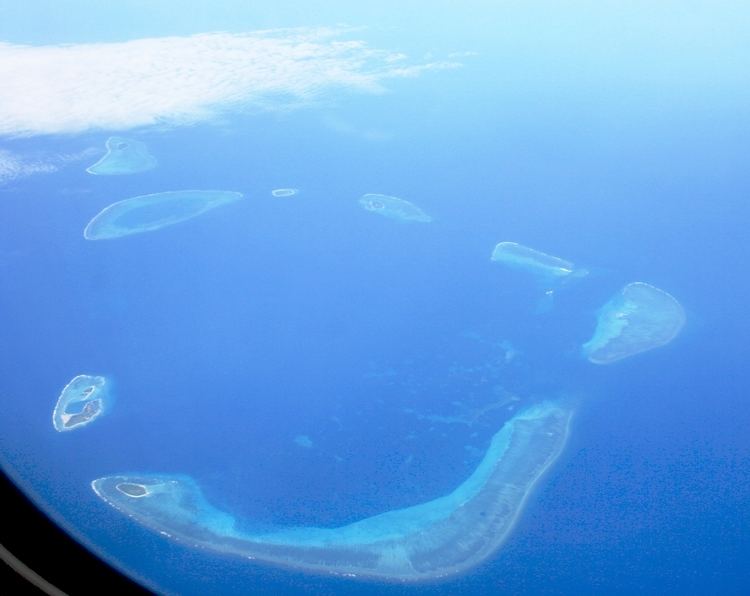
Paracel islands 2007 from google earth
The Paracel Islands, also known as Xisha in Chinese and Hoàng Sa in Vietnamese, is a group of islands, reefs, banks and other maritime features in the South China Sea. It is controlled (and occupied) by the People's Republic of China, and also claimed by Taiwan (Republic of China) and Vietnam.
Contents
- Paracel islands 2007 from google earth
- Chinese ship attacked and sank a vietnamese fishing boat near paracel islands 26th may 2014
- Geography
- Amphitrite Group
- Crescent Group
- Other features
- Southeast
- Eastern sub group
- Northeast
- ENE Ampitrite Group
- Northwest
- Inner Southwest
- Outer Southwest
- Central
- ESE
- Xisha and other Chinese names
- Hong Sa
- Pracel and Paracel
- East India Company
- Territorial disputes and their historical background
- UNCLOS EEZ
- Military engagement
- 6181279
- 12791368
- 13681912
- 19121950s
- 15th17th centuries
- 17001799
- 18001899
- 20th century events
- 21st century events and Land Reclamation
- In popular culture
- United States FIPS country code
- References
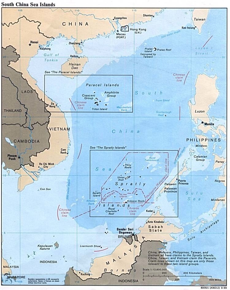
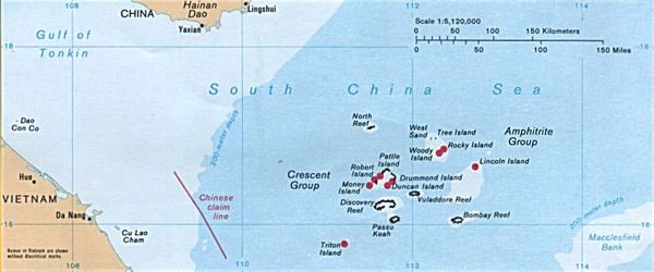
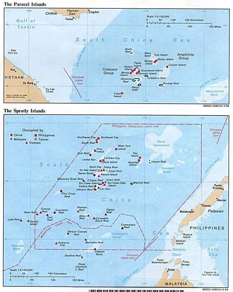
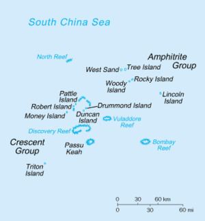
The archipelago includes about 130 small coral islands and reefs, most grouped into the northeast Amphitrite Group or the western Crescent Group. They are distributed over a maritime area of around 15,000 square kilometres (5,800 sq mi), with a land area of approximately 7.75 square kilometres (2.99 sq mi). The archipelago is approximately equidistant from the coastlines of China (PRC) and Vietnam; and approximately about one-third of the way from central Vietnam to the northern Philippines. It is home to Dragon Hole, the deepest, underwater sinkhole in the world.
Forces of the Republic of China (RoC) landed on Woody Island in the Amphitrite Group in November 1946 but abandoned it in May 1950. The Amphitrite were thus unoccupied until forces of the People's Republic of China landed in late 1955.
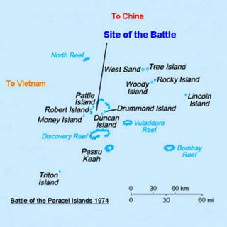
Meanwhile, French and Vietnamese forces landed on Pattle Island in the Crescent Group in January 1947. By 1955 South Vietnam took possession of the Crescent islands until the Battle of the Paracel Islands in January 1974. South Vietnam's claim to the islands was inherited by the Socialist Republic of Vietnam, which has ruled all of Vietnam since 1976.
In July 2012, China (PRC) declared a city named Sansha, under Hainan Province, as administering the area.
Turtles and seabirds are native to the islands, which have a hot and humid climate, abundant rainfall and frequent typhoons. The archipelago is surrounded by productive fishing grounds and a seabed with potential, but as yet unexplored, oil and gas reserves.
As of February 2017, the Asia Maritime Transparency initiative reported 20 outposts of China built on reclaimed land in the Spratlys, three of which consist of small harbours capable of berthing naval and commercials ships.
Chinese ship attacked and sank a vietnamese fishing boat near paracel islands 26th may 2014
Geography
Amphitrite Group
The Amphitrite group was named after the French frigate Amphitrite of the Jesuit missionary.
Lying in the northeast of the Paracel Islands at 16°53′N 112°17′E, the group consists of low narrow islands with sand cays, enclosed shallow lagoons connected by reefs of rock, and is about 37 km (23 mi) northwest of Lincoln Island. The group approximately forms an ellipse with a north-south axis of 22 km (14 mi).
The northern section of the group comprises West Sand, Tree Island and the Qilian Yu sub-group (The "Seven Sisters": North Island, Middle Island, South Island, North Sand, Middle Sand, South Sand and two small "sands".) The centre of the group consists of Woody Island and Rocky Island, approximately 5 km (3 mi) south of the southern tip of the eastern extremity of the northern section. The southwest corner of the group is occupied by the Iltis Bank.
The largest island of the Paracels, Woody Island (which has an area of 213 ha (530 acres)), has over 1,000 residents including fishermen and their families, military personnel and civilian administrators.
Crescent Group
Lying about 70 km (43 mi) southwest of the Amphitrite group, at 16.5°N 111.7°E / 16.5; 111.7, the Crescent group consists of islands and reefs that form a crescent-like structure from west to east, enclosing a deep central lagoon. The group measures 31 by 15 km (19 by 9 mi) east-west and north-south. All of the islands in the group support vegetation except on their small cays.
The islands are named after former senior figures in the British East India Company. Three were members of the EIC's 'Select Committee' in Canton: James Drummond, Thomas Pattle and John William Roberts. Jonathan Duncan was Governor in Council of Bombay and William Taylor Money was Superintendent of the Bombay Marine. The Chinese name for Money Island is simply the translation of the word 'money - Jin Yin Dao. Money Island' lies at the southwest extremity of the group, and has some small cays in the southern side.
Antelope Reef, submerged at high tide and containing a central lagoon, lies 2.4 km (1.5 mi) east of Money Island.
Northeast of this are Robert Island (also named Round Island) and Pattle Island, separated from each other by a 3.5 km (2.2 mi) wide deep channel. A weather station was built on Pattle Island (by the French) in 1932, and a lighthouse and radio station in 1937.
Northeast of this is Quanfu Dao ("All Wealth Island").
Observation Bank, also named Silver Islet, and the Lesser Silver Islet, are the northernmost of the group and contain a small cay. Just south of them are Yagong Dao (He Duck) and Xianshe Yu (Salty Hut).
At the eastern side of the group lies a 12 km (7 mi) long boomerang shaped reef with Stone Islet at its north end and Drummond Island at its south end.
The Duncan Islands (16°27′N 111°43′E), consisting of Duncan Island and Palm Island, lie approximately 3 km (2 mi) west of Drummond Island and about 8 km (5 mi) east of Antelope Reef. Kuangzai Shazhou (Little Basket) lies about halfway between Palm Island and Antelope Reef.
Other features
Taking 16°40′N 112°20′E as the centre of the Paracel Islands, then the Amphitrite Group is ENE, and the Crescent Group is West.
Southeast
Eastern sub-group
Northeast
(ENE: Ampitrite Group)
16°53′N 112°17′E
Northwest
Inner Southwest
Outer Southwest
Central
ESE
Xisha and other Chinese names
The Chinese name Xisha (西沙), literally "western sands" or "shoals", is a name adopted in the 20th century to distinguish it from the "eastern sands" (the Dongsha or Pratas), the "southern sands" (the Nansha or Spratlys), and the "central sands" (the Zhongsha or Macclesfield Bank). Prior to that, there had been no consistent designation of these islands in early Chinese sources, with names such as Changsha, Shitang, Shichuang and others being used for Paracel and Spratly inconsistently. In the Song Dynasty work Zhu fan zhi by Zhao Rugua, the names Qianli Changsha (千里長沙, lit. "Thousand mile-Long Sands") and Wanlishichuang (萬里石床 lit. "Ten-thousand mile-Rock Bed") were given, interpreted by some to refer to Paracel and Spratly respectively, but opinions differed. The Yuan dynasty work Daoyi Zhilüe by Wang Dayuan considers that Shitang (石塘) to be the same as Wanli Shitang (萬里石塘, lit. "Ten-thousand mile-Rock Embankment"), which starts from Chaozhou and extends to Borneo, west to Côn Sơn Island off Vietnam and down as far as Java. The History of Yuan uses the terms Qizhouyang (七洲洋, "The Ocean of Seven Islands") and Wanli Shitang, which are taken to mean Paracel and Spratly respectively. In the Mao Kun map from the Zheng He's voyage of the early 15th century, groups of islands were named as Shitang (石塘), Wansheng Shitangyu (萬生石塘嶼), and Shixing Shitang (石星石塘), with Shitang (sometimes including Wansheng Shitangyu) being taken by some to mean Paracel. Another Ming text, Haiyu (On the Sea), uses Wanli Shitang to refer to Paracel and Wanli Changsha for Spratly.
During the Qing dynasty, a set of maps refer to Paracel as Qizhouyang (Shitang became Spratly, and Changsha became Zhongsha), while a book Hai Lu (Illustrations of the Sea) refers to Paracel as Changsha and Spratly as Shitang. A sea chart prepared in the Daoguang era, Yiban Lu (Particular Illustrations) by Zheng Guangzu, uses Xisha to refer to Paracel. Xisha was also used in 20th century maps published by the Republic of China, for example in 1935, and the 1947 11-dash line map which claimed Paracel and Spratly as its territories.
Hoàng Sa
The Vietnamese call the islands Hoang Sa, (黃沙 or Yellow Sands), and this name is found in historic Vietnamese documents dating back to the 15th century. In the modern language system it is written as Hoàng Sa or Cát Vàng. They all have the same meaning — the Yellow Sands or the Yellow Sandbank. Before the early 19th century, the present-day Spratly Islands were treated as features of Hoàng Sa. It was not until the reign of Emperor Minh Mạng (1820–1841) that the Spratlys were distinctly delineated and officially named Vạn Lý Trường Sa (萬里長沙), the Ten-thousand League-long Sandbank.
Chinese researcher Li Jinming, however, claims that the original "Hoang Sa" in historic Vietnamese documents is along the coast of the Vietnamese shore, and not the modern Paracel or Spratly Islands.
Pracel and Paracel
The name 'Paracel' is found in the first Portuguese maps of the region. The Portuguese, whose vessels frequented the South China Sea as early as at the beginning of the 16th century, were the first to refer to these islands as 'Ilhas do Pracel' in the 16th century.
Regarding the likely origin of the term Paracel, the word is a variant of the more common form pracel or parcel, from the Spanish: placer, which was used by the Portuguese and Spanish navigators to designate shallow sandy seas or submerged banks, such as Placer de los Roques.
Pracel is a moderately elevated chain of islets, sandbanks, and reefs. These features are continuously distributed and stretched over a noticeable distance of tens or hundreds of kilometers in length. Pracel may not be a suitable place for human residents, but its irregular depth creates an ideal environment inhabited by fish. Pracel often forms a natural bulwark as an outer line of defense for a coast or a land.
The Portuguese were later followed by the Dutch, the English, the Spanish, and the French in the waters of the island group. On the "Map of the coast of Tonquin and Cochinchina", made in 1747 by Pierre d'Hondt, the dangerous band of rugged rocks was labeled "Le Paracel", a French phonetic notation. Because of their location on an important seaborne route the Paracel Islands drew much attention from navigators and hydrographers in the Age of Exploration. Disputes in the area since the Second World War have again drawn attention to the islands.
On the "Map of Europe, Africa and Asia" published in 1598 by Cornelis Claesz, an unnamed band of rocks and sandbanks are shown near the present-day location of the Paracel and Spratly Islands. About two decades later, the names Pracel and Costa de Pracel (Coast of Pracel) appeared on the Chart of Asia and eight city maps published in 1617 by Willem Jansz Blaeu, a Dutch map maker. The coast belonged to the Kingdom of Cauchi China.
East India Company
The islands were first scientifically surveyed by Daniel Ross of the British East India Company in 1808. The names of Duncan, Drummond, Money, Pattle and Roberts islands were all chosen in honour of senior figures in the East India Company.
Territorial disputes and their historical background
China first asserted sovereignty in the modern sense to the South China Sea’s islands when it formally objected to France’s efforts to incorporate them into French Indochina during the 1884–1885 Sino-French war. After the war, France recognized the Paracel's and Spratly's islands as Chinese territories, in exchange for Chinese recognition of Vietnam as a French territory. Chinese maps since then have consistently shown China’s claims, first as a solid and then as a dotted line. Between 1881 and 1883 the German navy surveyed the islands continuously for three months each year without seeking the permission of either France or China. No protest was issued by either government and the German government published the results of the survey in 1885. In 1932, France nonetheless formally claimed both the Paracel and Spratly Islands. China and Japan both protested. In 1933, France seized the Paracels and Spratlys, announced their annexation, formally included them in French Indochina, and built a couple of weather stations on them, but did not disturb the numerous Chinese fishermen it found there. In 1941, the Japanese Empire made the Paracel and Spratly islands part of Taiwan, then under its rule.
After the communists gained control of China in 1949, they occupied Woody Island, the main island of the Amphitrite group and the only island that was occupied at the time. Pattle Island in the Crescent group, on the other hand, was later taken by French Indochina and then controlled by South Vietnam following independence in 1956. Tensions over the islands have continued to rise unceasingly since then.
UNCLOS EEZ
The Paracel islands are claimed by both China and Vietnam and the majority of those islands lie within 200 NM of China's and Vietnam's geographic baseline.
Military engagement
In 1974, the political and diplomatic dispute over the islands became an armed conflict between China and South Vietnam. On January 16, South Vietnamese naval officers and an American observer reported to Saigon some suspected military activities of the Chinese navy on the Drummond and Duncan islands. After receiving the report, the government of South Vietnam decided to counter the Chinese forces, to defend the South Vietnamese-controlled section (the western half of the Paracels) from Chinese occupation, and sent a unit of frigates to the area. On January 19, there were sea and land battles between the Chinese and Vietnamese forces with casualties on both sides. At the end, the Chinese fleet defeated the naval force of South Vietnam. With the ongoing civil war with the Viet Cong embroiling South Vietnam's attention and the absence of the USA's support, no military attempt was made to re-engage the PRC over the islands. After the military engagement and the subsequent victory, the PRC gained the entire archipelago and has taken control of Paracel Islands ever since. It was a significant turning point for the PRC but the sovereignty dispute on the islands remains unresolved with Vietnam.
618–1279
There are some Chinese cultural relics in the Paracel islands dating from the Tang and Song eras, and there is some evidence of Chinese habitation on the islands during these periods. According to the Wujing Zongyao, a book published in the Northern Song dynasty in 1044, the Song government then included the Islands in the patrol areas of the Navy of the Court.
1279–1368
In 1279, the Yuan dynasty emperor sent the high-level official and astronomer, Guo Shoujing, to the South China Sea to survey and measure the islands and the surrounding sea area. Guo's base of survey was located in the Paracel Islands. His activities were recorded in the Yuan Shi, or History of Yuan. According to the Yuan Shi, the South China Sea islands were within the boundary of the Yuan dynasty. Maps published in the Yuan era invariably included the Changsha (the Paracels) and the Shitang (the Spratlys) within the domain of Yuan.
1368–1912
Relevant local annals and other historic materials of the Ming (1368–1644) and the Qing (1644–1912) dynasties continued to make reference to the South China Sea islands as China's territory. The Qiongzhou Prefecture (the highest administrative authority in Hainan), exercised jurisdiction over the Paracel and Spratly Islands in the Ming and Qing Dynasties.
In the 19th century, Europeans found that Chinese fishermen from Hainan annually sojourned on the Paracel and Spratly islands for part of the year.
When the Spratlys and Paracels were being surveyed by Germany in 1883, China issued protests against them.. In 1910, the Qing government decided to invite Chinese merchants to contract for the administration of the development affairs of the South China Sea islands, and demanded that officials shall provide protection and maintenance in order to highlight Chinese territory and protect its titles and interests.
1912–1950s
After the fall of the Qing dynasty, the new Government of Guangdong Province decided to place the Paracel Islands under the jurisdiction of the Ya Xian County of Hainan Prefecture in 1911. The Southern Military Government in 1921 reaffirmed the 1911 decision. China continued to exercise authority over the South China Sea islands by such means as granting licenses or contracts to private Chinese merchants for the development and exploitation of guano and other resources on those islands and protesting against foreign nations' claims, occupations, and other activities.
On July 27, 1932, the Chinese Foreign Ministry instructed the Chinese Envoy to France to lodge a diplomatic protest to the French Foreign Ministry and to deny France's claims to the Paracel Islands. On November 30 of the same year, Zhu Zhaoshen, a high-level inspection official of the Chinese Foreign Ministry, issued public correspondence Number 66 to the French Consul in Guangzhou, reiterating that "it is absolutely beyond doubt that the Xisha [Paracel] Islands fall within the boundary of China". Despite repeated Chinese protests, French troops, who had colonized Indochina in the 19th century, invaded and occupied the Paracel Islands on July 3, 1938. This took place shortly after the breakout of the Second Sino-Japanese War, when the armed forces of China and Japan were busy elsewhere. Three days later, on July 6, the Japanese Foreign Ministry also issued a declaration in protest of the French occupation:
The statement of Great Britain and France made respectively in 1900 and 1921 already declared that the Xisha [Paracel] Islands were part of the Administrative Prefecture of Hainan Island. Therefore, the current claims made by An'nan or France to the Xisha Islands are totally unjustifiable.
During the Second World War, Japanese expelled the French troops and took over the islands in spite of the 1938 declarations. The Spratlys and the Paracels were conquered by Japan in 1939. Japan administered the Spratlys via Taiwan's jurisdiction and the Paracels via Hainan's jurisdiction. The Paracels and Spratlys were handed over to Republic of China control from Japan after the 1945 surrender of Japan, since the Allied powers assigned the Republic of China to receive Japanese surrenders in that area. At the end of the war (Asian-Pacific Region), Nationalist China formally retook the Paracels, Spratlys and other islands in the South China Sea in October and November 1946. In Geneva accord of 1954 Japan formally renounced all of its claims to, inter alia, the South China Sea islands which it had occupied during the World War II. After WW2 ended, the Republic of China was the "most active claimaint". The Republic of China then garrisoned Woody island in the Paracels in 1946 and posted Chinese flags and markers on it, France tried, but failed to make them leave Woody island. The aim of the Republic of China was to block the French claims. In December 1947, the Republic of China drew up its map showing its U shaped claim on the entire South China Sea, showing the Spratly and Paracels in Chinese territory.
15th–17th centuries
1700–1799
1800–1899
20th-century events
21st-century events and Land Reclamation
In popular culture
United States FIPS country code
The United States FIPS 10-4 country code for the Paracel Islands is PF.