
Government Monarchy Today part of Vietnam Area 40.24 km² Area code 07819 | Established 192 Elevation 253 m Population 211,189 (2011) Local time Thursday 5:44 AM | |
 | ||
Capital Kandapurpura (192 – 605)Simhapura (605 – 757)Virapura (757 – 875)Indrapura(875 – 982)Vijaya(982 – 1471)Panduranga (1471–1832) Languages Chamic languages, Malay, Sanskrit Religion Islam, Hinduism and Buddhism Weather 20°C, Wind NE at 0 km/h, 95% Humidity Neighborhoods Sanjay Nagar, Shanti Nagar, Shiv Nagar | ||
The term Champa refers to a collection of independent Cham polities that extended across the coast of what is today central and southern Vietnam from approximately the 2nd century through 19th century (1832), before being absorbed and annexed by the Vietnamese state. The kingdom was known variously as nagara Campa (Sanskrit: नगरः कम्पः; Khmer: ចាម្ប៉ា) in the Chamic and Cambodian inscriptions, Chăm Pa in Vietnamese (Chiêm Thành in Sino-Vietnamese vocabulary) and 占城 (Zhànchéng) in Chinese records.
Contents
- Map of Champa Chhattisgarh 495671
- Geography of historical Champa
- Sources
- Overarching theories
- Sources of foreign cultural influence
- Islam
- Hinduism and Buddhism
- Economy
- Religious
- Defended centers
- Museums
- Popular Culture
- References
Map of Champa, Chhattisgarh 495671
The Chams of modern Vietnam and Cambodia are the remnants of this former kingdom. They speak Chamic languages, a subfamily of Malayo-Polynesian closely related to the Malayic and Bali–Sasak languages.
Champa was preceded in the region by a kingdom called Linyi (林邑, Lim Ip in Middle Chinese) or Lâm Ấp (Vietnamese) that was in existence from AD 192; the historical relationship between Linyi and Champa is not clear. Champa reached its apogee in the 9th and 10th centuries. Thereafter, it began a gradual decline under pressure from Đại Việt, the Vietnamese polity centered in the region of modern Hanoi. In 1832, the Vietnamese emperor Minh Mạng annexed the remaining Cham territories.
Hinduism, adopted from India since early in its history, has shaped the art and culture of Champa kingdom for centuries, as testified by the many exquisite Cham Hindu statues and red brick temples which dotted the landscapes in Cham lands. Mỹ Sơn, a former religious center, and Hội An, one of Champa's main port cities, are now World Heritage Sites. Today, some Cham people adhere to Buddhism, a conversion which was started in 15th century; they are called Bani Cham. There are, however, Chams who still retain and preserve their Hindu faith, rituals and festivals. The Balamon Cham are one of only two surviving non-Indic indigenous Hindu peoples in the world, with a culture dating back thousands of years. The other is the Hindu Balinese of Indonesia.
Geography of historical Champa
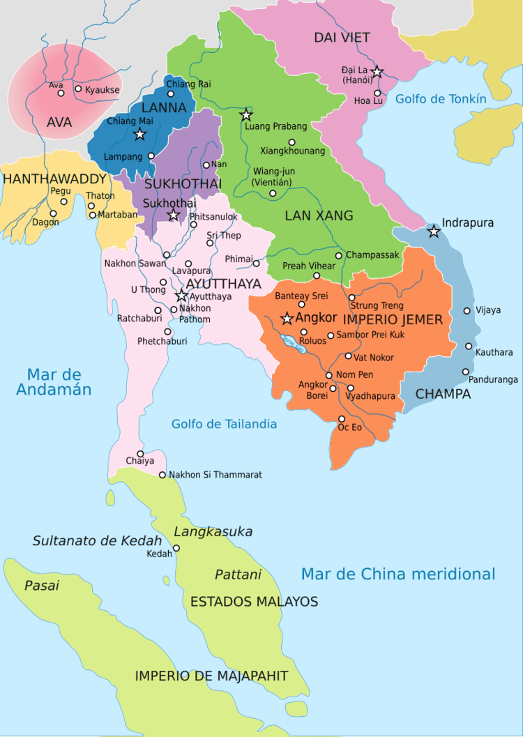
Between the 2nd and the 15th centuries, Champa at times included the modern provinces of Quảng Nam, Quảng Ngãi, Bình Định, Phú Yên, Khánh Hòa, Ninh Thuận, and Bình Thuận. Though Cham territory included the mountainous zones west of the coastal plain and (at times) extended into present-day Laos, for the most part, the Cham remained a seafaring people dedicated to trade, and maintained few settlements of any size away from the coast.
Historical Champa consisted of up to five principalities:
Within the four principalities were two main clans: the "Dua" and the "Cau". The Dua lived in Amravati and Vijaya, while the Cau lived in Kauthara and Panduranga. The two clans differed in their customs and habits and conflicting interests led to many clashes and even war. But they usually managed to settle disagreements through intermarriage.
Sources
The historiography of Champa relies upon three types of sources:
Overarching theories
Modern scholarship has been guided by two competing theories in the historiography of Champa. Scholars agree that historically Champa was divided into several regions or principalities spread out from south to north along the coast of modern Vietnam and united by a common language, culture, and heritage. It is acknowledged that the historical record is not equally rich for each of the regions in every historical period. For example, in the 10th century, the record is richest for Indrapura; in the 12th century, it is richest for Vijaya; following the 15th century, it is richest for Panduranga. Some scholars have taken these shifts in the historical record to reflect the movement of the Cham capital from one location to another. According to such scholars, if the 10th-century record is richest for Indrapura, it is so because at that time Indrapura was the capital of Champa. Other scholars have disputed this contention, holding that Champa was never a united country, and arguing that the presence of a particularly rich historical record for a given region in a given period is no basis for claiming that the region functioned as the capital of a united Champa during that period.
Sources of foreign cultural influence
Through the centuries, Cham culture and society were influenced by forces emanating from Cambodia, China, Java and India amongst others. Lin Yi, a predecessor state in the region, began its existence in AD 192 as a breakaway Chinese colony. An official successfully revolted against Chinese rule in central Vietnam, and Lin Yi was founded in 192. In the 4th century, wars with the neighbouring Kingdom of Funan in Cambodia and the acquisition of Funanese territory led to the infusion of Indian culture into Cham society. Sanskrit was adopted as a scholarly language, and Hinduism, especially Shaivism, became the state religion. From the 10th century onwards, Arab maritime trade in the region brought increasing Islamic cultural and religious influences. Champa came to serve as an important link in the spice trade, which stretched from the Persian Gulf to South China, and later in the Arab maritime routes in Mainland Southeast Asia as a supplier of aloe. Despite the frequent wars between Champa and Cambodia, the two countries also traded and cultural influences moved in both directions. Royal families of the two countries intermarried frequently. Champa also had close trade and cultural relations with the powerful maritime empire of Srivijaya and later with the Majapahit of the Malay Archipelago.
Evidence gathered from linguistic studies around Aceh confirms that a very strong Champan cultural influence existed in Indonesia; this is indicated by the use of the Chamic language Acehnese as the main language in the coastal regions of Pidie, Aceh Besar, Aceh Jaya, North Aceh, East Aceh, West Aceh and Southwest Aceh Regencies and the cities of Lhokseumawe and Bireuën.
Islam
Chams participated in defeating the Spanish invasion of Cambodia.
Cambodian king Cau Bana Cand Ramadhipati launched the Cambodian–Dutch War to expel the Dutch. The Vietnamese Nguyen Lords toppled Ibrahim from power to restore Buddhist rule.
After Vietnam invaded and conquered Champa, Cambodia granted refuge to Cham Muslims escaping from Vietnamese conquest. [39]
Cham who migrated to Sulu were Orang Dampuan.[40] Champa and Sulu enaged in commerce with each other which resulted in merchant Chams settling in Sulu where they were known as Orang Dampuan from the 10th-13th centuries. The Orang Dampuan were slaughtered by envious native Sulu Buranuns due to the wealth of the Orang Dampuan.[41] The Buranun were then subjected to retaliatory slaughter by the Orang Dampuan. Harmonious commerce between Sulu and the Orang Dampuan was later restored.[42] The Yakans were descendants of the Taguima based Orang Dampuan who came to Sulu from Champa.[43] Sulu received civilization in its Indic form from the Orang Dampuan.[44]
The trade in Vietnamese ceramics was damaged due to the plummet in trade by Cham merchants after the 1471 Vietnamese invasion of Champa.[45] Vietnam's export of ceramics was also damaged by its internal civil war, the Portuguese and Spanish entry into the region and the Portuguese conquest of Malacca which caused an upset in the trading system, while the carracks ships in the Malacca to Macao trade run by the Portuguese docked at Brunei due to good relations between the Portuguese and Brunei after the Chinese permitted Macao to be leased to the Portuguese.[46]
Hinduism and Buddhism
While today the Balamon Cham are the only surviving Hindus in Vietnam, the region once hosted some of the most exquisite and vibrant Hindu cultures in the world. The entire region of Southeast Asia, in fact, was home to numerous sophisticated Hindu kingdoms. From Angkor in neighboring Cambodia, to Java and Bali in Indonesia.
Before the conquest of Champa by the Đại Việt emperor Tran Thánh Tông in 1471, the dominant religion of the Cham people was Hinduism, and the culture was heavily influenced by that of India. The Hinduism of Champa was overwhelmingly Shaiva and it was liberally combined with elements of local religious cults such as the worship of the Earth goddess Lady Po Nagar. The main symbols of Cham Shaivism were the lingam, the mukhalinga, the jaṭāliṅgam, the segmented liṅgam, and the kośa.
The predominance of Hinduism in Cham religion was interrupted for a time in the 9th and 10th centuries, when a dynasty at Indrapura (modern Dong Duong, Quảng Nam Province, Vietnam) adopted Mahayana Buddhism as its faith. The Buddhist art of Dong Duong has received special acclaim for its originality.
Beginning in the 10th century, Hinduism again became the predominant religion of Champa. Some of the sites that have yielded important works of religious art and architecture from this period are, aside from Mỹ Sơn, Khuong My, Trà Kiệu, Chanh Lo, and Thap Mam.
Buddhism started making more headway among the Cham after the 10th century. By the 17th century, the royal families of the Cham had converted to Buddhism. Most Cham are now evenly split between being followers of Buddhist and Hindu, with the majority of Vietnamese Cham being Hindu while the majority of Cambodian Cham are Muslim, though significant minorities of Mahayana Buddhists continue to exist.
Japanese 15th century records indicate the influence of Princess Daravati, a Cham, converted to Buddhism, and influenced her husband, Kertawijaya, Majapahit's seventh ruler to convert the Majapahit royal family to Buddhism. The Buddhist tomb of Putri Champa (Princess of Champa) can be found in Trowulan, East Java, the site of the Majapahit imperial capital. In the 15th to 17th century, Buddhist Cham maintained a cordial relationship with the Korean kingdom through dynastic marriage. This was located on the northern tip of Sumatra and was an active promoter of the Buddhist faith.
Economy
In contrast to Đại Việt, Champa's economy was not based on agriculture. As seafaring people, the Cham were highly mobile and established a network of trade including not only the major ports at Hội An, Thi Nai but also extending into the mountainous hinterland. Maritime trade was facilitated by a network of wells that provided fresh water to Cham and foreign ships along the coast of Champa and the islands of Cu Lao Cham and Ly Son. While Kenneth R. Hall suggests that Champa was not able to rely on taxes on trade for continuous revenue, but instead financed their rule by raiding neighbouring countries, Hardy argues that the country's prosperity was above all based on commerce.
The vast majority of Champa's export products came from the mountainous hinterland, sourced from as far as Attapeu in southern Laos. They included gold and silver, slaves, animal and animal products, and precious woods. By far the most important export product was eaglewood. It was the only product mentioned in Marco Polo's brief account and similarly impressed the Arab trader Sulayman several centuries earlier. Most of it was probably taken from the Aquilaria crassna tree, just as most of the eaglewood in Vietnam today.
Religious
Defended centers
Some of the network of wells that was used to provide fresh water to Cham and foreign ships still remains. Cham wells are recognisable by their square shape. They are still in use and provide fresh water even during times of drought.
Museums
The largest collection of Cham sculpture may be found in the Da Nang Museum of Cham Sculpture (formerly known as "Musée Henri Parmentier") in the coastal city of Da Nang. The museum was established in 1915 by French scholars, and is regarded as one of the most beautiful in Southeast Asia. Other museums with collections of Cham art include the following:
Popular Culture
Champa is a playable nation in Europa Universalis IV.