
Founded 6 March 1840 Population 41,153 (2013) | Website www.co.ottawa.oh.us Area 1,515 km² | |
 | ||
Named for the Ottawa tribe or a word meaning "trader" Rivers Crane Creek, Portage River, Toussaint Creek, Wolf Creek Destinations Points of interest Middle Bass Island, South Bass Island, Perry's Victory and Internatio, African Safari Wildlife P, Marblehead Light | ||
Ottawa County is a county located in the U.S. state of Ohio. As of the 2010 census, the population was 41,428. Its county seat is Port Clinton. The county is named either for the Ottawa Indians who lived there, or for an Indian word meaning "trader".
Contents
- Map of Ottawa County OH USA
- History
- Geography
- Adjacent counties
- National protected areas
- 2000 census
- 2010 census
- County officials
- Major highways
- Airports
- City
- Census designated places
- Notable residents
- References
Map of Ottawa County, OH, USA
Ottawa County comprises the Port Clinton, OH Micropolitan Statistical Area, which is also included in the Toledo-Port Clinton, OH Combined Statistical Area.
History
On September 10, 1813, during the War of 1812, nine vessels of the United States Navy under Commodore Oliver Hazard Perry, decisively defeated six vessels of Great Britain’s Royal Navy in the Battle of Lake Erie near Put-in-Bay. This action was one of the major battles of the war.
Ottawa County was formed on March 6, 1840 from portions of Erie, Lucas and Sandusky counties. It was named after the North American Indian tribe of the Ottawa.
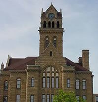
In 1974, the County Courthouse was listed on the National Register of Historic Places.
The county is notable in presidential politics for being a bellwether, having continuously voted for the winning candidate for thirteen elections beginning in 1964.
Geography
According to the U.S. Census Bureau, the county has a total area of 585 square miles (1,520 km2), of which 255 square miles (660 km2) is land and 330 square miles (850 km2) (56%) is water. It is the third-smallest county in Ohio by land area. It borders Ontario across Lake Erie.
Adjacent counties
National protected areas
2000 census
As of the census of 2000, there were 40,985 people, 16,474 households, and 11,729 families residing in the county. The population density was 161 people per square mile (62/km²). There were 25,532 housing units at an average density of 100 per square mile (39/km²). The racial makeup of the county was 96.56% White, 0.65% Black or African American, 0.21% Native American, 0.23% Asian, 0.05% Pacific Islander, 1.44% from other races, and 0.87% from two or more races. 3.75% of the population were Hispanic or Latino of any race.
There were 16,474 households out of which 29.10% had children under the age of 18 living with them, 58.90% were married couples living together, 8.50% had a female householder with no husband present, and 28.80% were non-families. 25.00% of all households were made up of individuals and 11.20% had someone living alone who was 65 years of age or older. The average household size was 2.45 and the average family size was 2.92.
In the county, the population was spread out with 23.30% under the age of 18, 6.70% from 18 to 24, 26.80% from 25 to 44, 26.80% from 45 to 64, and 16.40% who were 65 years of age or older. The median age was 41 years. For every 100 females there were 97.50 males. For every 100 females age 18 and over, there were 94.70 males.
The median income for a household in the county was $44,224, and the median income for a family was $51,919. Males had a median income of $39,823 versus $24,727 for females. The per capita income for the county was $21,973. About 4.20% of families and 5.90% of the population were below the poverty line, including 7.40% of those under age 18 and 5.40% of those age 65 or over.
2010 census
As of the 2010 United States Census, there were 41,428 people, 17,503 households, and 11,884 families residing in the county. The population density was 162.5 inhabitants per square mile (62.7/km2). There were 27,909 housing units at an average density of 109.5 per square mile (42.3/km2). The racial makeup of the county was 96.5% white, 0.8% black or African American, 0.3% Asian, 0.2% American Indian, 0.9% from other races, and 1.3% from two or more races. Those of Hispanic or Latino origin made up 4.2% of the population. In terms of ancestry, 44.6% were German, 11.9% were Irish, 9.8% were English, 6.3% were American, and 6.1% were Polish.
Of the 17,503 households, 26.3% had children under the age of 18 living with them, 54.7% were married couples living together, 8.9% had a female householder with no husband present, 32.1% were non-families, and 27.4% of all households were made up of individuals. The average household size was 2.34 and the average family size was 2.82. The median age was 46.3 years.
The median income for a household in the county was $53,463 and the median income for a family was $64,258. Males had a median income of $52,736 versus $33,557 for females. The per capita income for the county was $27,809. About 6.3% of families and 9.0% of the population were below the poverty line, including 11.9% of those under age 18 and 6.5% of those age 65 or over.
County officials
The County elects 9 holders.
Major highways
10 major highways run through Ottawa County, including two interstates, and eight state routes.