
Country United States Elevation 627 ft (191 m) Zip code 43440 | State Ohio Township Danbury Time zone Eastern (EST) (UTC-5) Population 891 (2013) | |
 | ||
Weather 6°C, Wind E at 3 km/h, 92% Humidity Hotels Bay Point Resort and Marina, The Lighthouse Resort, Taylor's Resort | ||
Marblehead is a village in Ottawa County, Ohio, United States. The population was 903 at the 2010 census.
Contents
- Map of Marblehead Lakeside Marblehead OH 43440 USA
- The keeper s house marblehead ohio
- Geography
- 2010 census
- 2000 census
- References
Map of Marblehead, Lakeside Marblehead, OH 43440, USA
It sits at the tip of the Marblehead Peninsula, which divides Lake Erie proper from Sandusky Bay. In the summer, it is a popular vacation area because of its lake frontage, ferry service to the Lake Erie Islands, quality sport fishery, the nearby Chautauqua at Lakeside, and the Cedar Point amusement park.
Marblehead is also commercially important as a major limestone producer. The limestone is mined in nearby quarries and transported by conveyor belt to the Marblehead boat loading dock, where it is loaded on commercial lake freighters. The blocks of stone used to construct the Stannard Rock Light on Lake Superior were cut at Marblehead and hauled to the site from 1877 to 1881.
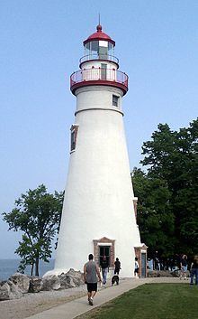
Marblehead is also home to a United States Coast Guard station, and to the Marblehead Lighthouse, the oldest continuously operating lighthouse on the Great Lakes. Nearby, in Sandusky Bay, is Johnson's Island, a former Confederate officer POW camp during the Civil War.
The keeper s house marblehead ohio
Geography
Marblehead is located at 41°32′05″N 82°43′45″W.
According to the United States Census Bureau, the village has a total area of 4.31 square miles (11.16 km2), of which 3.31 square miles (8.57 km2) is land and 1.00 square mile (2.59 km2) is water.
2010 census
As of the census of 2010, there were 903 people, 417 households, and 285 families residing in the village. The population density was 272.8 inhabitants per square mile (105.3/km2). There were 942 housing units at an average density of 284.6 per square mile (109.9/km2). The racial makeup of the village was 98.7% White, 0.2% African American, 0.1% Native American, 0.3% Asian, 0.1% from other races, and 0.6% from two or more races. Hispanic or Latino of any race were 1.7% of the population.
There were 417 households of which 18.0% had children under the age of 18 living with them, 60.2% were married couples living together, 4.6% had a female householder with no husband present, 3.6% had a male householder with no wife present, and 31.7% were non-families. 28.3% of all households were made up of individuals and 15.8% had someone living alone who was 65 years of age or older. The average household size was 2.17 and the average family size was 2.57.
The median age in the village was 55.7 years. 15.9% of residents were under the age of 18; 4.6% were between the ages of 18 and 24; 13.5% were from 25 to 44; 37.3% were from 45 to 64; and 28.8% were 65 years of age or older. The gender makeup of the village was 49.7% male and 50.3% female.
2000 census
As of the census of 2000, there were 762 people, 332 households, and 239 families residing in the village. The population density was 268.9 people per square mile (104.0/km2). There were 973 housing units at an average density of 343.3 per square mile (132.7/km2). The racial makeup of the village was 97.90% White, 0.26% African American, 0.26% Native American, 0.26% Asian, 0.66% from other races, and 0.66% from two or more races. Hispanic or Latino of any race were 1.44% of the population.
There were 332 households out of which 18.4% had children under the age of 18 living with them, 62.3% were married couples living together, 6.9% had a female householder with no husband present, and 28.0% were non-families. 25.3% of all households were made up of individuals and 14.8% had someone living alone who was 65 years of age or older. The average household size was 2.26 and the average family size was 2.68.
In the village, the population was spread out with 16.9% under the age of 18, 6.6% from 18 to 24, 19.3% from 25 to 44, 32.3% from 45 to 64, and 24.9% who were 65 years of age or older. The median age was 49 years. For every 100 females there were 96.9 males. For every 100 females age 18 and over, there were 97.8 males.
The median income for a household in the village was $46,528, and the median income for a family was $52,250. Males had a median income of $39,688 versus $24,545 for females. The per capita income for the village was $26,184. About 3.0% of families and 4.7% of the population were below the poverty line, including 3.2% of those under age 18 and 5.2% of those age 65 or over.