
Founded March 16, 1838 Area 1,621 km² | Named for Erie tribe Website www.eriecounty.oh.gov Population 76,048 (2013) Unemployment rate 5.6% (Apr 2015) | |
 | ||
Colleges and Universities BGSU Firelands, EHOVE Career Center, Ohio Business College, Firelands Regional Medical Destinations | ||
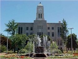
Erie County is a county located in the U.S. state of Ohio. As of the 2010 census, the population was 77,079. Its county seat is Sandusky. The county is named for the Erie tribe, whose name was their word for "wildcat". It was formed in 1838 from the northern third of Huron County and a portion of Sandusky County.
Contents
- Map of Erie County OH USA
- History
- Geography
- Adjacent counties and municipalities
- 2000 census
- 2010 census
- Politics
- Education
- Cities
- Villages
- Census designated places
- Places of interest
- References
Map of Erie County, OH, USA
Erie County comprises the Sandusky, OH Micropolitan Statistical Area, which is also included in the Cleveland-Akron-Canton, OH Combined Statistical Area.
It is home to the amusement park Cedar Point.
History
Erie County was initially created about 1838, and formed from a portion of Huron County (although a few subsequent changes to Erie County's boundaries occurred shortly after its initial formation).
Geography
According to the U.S. Census Bureau, the county has a total area of 626 square miles (1,620 km2), of which 252 square miles (650 km2) is land and 374 square miles (970 km2) (60%) is water. It is the second-smallest county in Ohio by land area after Lake County . The county borders Canada to the north across Lake Erie.
It is drained by Huron and Vermilion rivers. Near Huron River are several ancient mounds and enclosures, and at Sandusky are extensive quarries of valuable limestone. The surface is generally level, the soil alluvial and exceedingly fertile.
Adjacent counties and municipalities
2000 census
As of the census of 2000, there were 79,551 people, 31,727 households, and 21,764 families residing in the county. The population density was 312 people per square mile (121/km²). There were 35,909 housing units at an average density of 141 per square mile (54/km²). The racial makeup of the county was 88.64% White, 8.64% Black or African American, 0.21% Native American, 0.37% Asian, 0.01% Pacific Islander, 0.53% from other races, and 1.60% from two or more races. 2.09% of the population were Hispanic or Latino of any race. 35.7% were of German, 9.2% Irish, 8.2% English, 8.1% Italian and 7.8% American ancestry according to Census 2000.
There were 31,727 households out of which 30.40% had children under the age of 18 living with them, 53.70% were married couples living together, 11.20% had a female householder with no husband present, and 31.40% were non-families. 27.00% of all households were made up of individuals and 10.80% had someone living alone who was 65 years of age or older. The average household size was 2.45 and the average family size was 2.97.
In the county, the population was spread out with 24.70% under the age of 18, 7.20% from 18 to 24, 27.00% from 25 to 44, 25.50% from 45 to 64, and 15.60% who were 65 years of age or older. The median age was 40 years. For every 100 females there were 95.00 males. For every 100 females age 18 and over, there were 92.40 males.
The median income for a household in the county was $42,746, and the median income for a family was $51,756. Males had a median income of $39,249 versus $23,697 for females. The per capita income for the county was $21,530. About 6.00% of families and 8.30% of the population were below the poverty line, including 11.60% of those under age 18 and 6.80% of those age 65 or over.
In 2008, the Census Bureau announced that the county's population had declined to an estimated 77,323 by July 1, 2007.
2010 census
As of the 2010 United States Census, there were 77,079 people, 31,860 households, and 21,011 families residing in the county. The population density was 306.4 inhabitants per square mile (118.3/km2). There were 37,845 housing units at an average density of 150.4 per square mile (58.1/km2). The racial makeup of the county was 87.0% white, 8.6% black or African American, 0.6% Asian, 0.3% American Indian, 0.7% from other races, and 2.8% from two or more races. Those of Hispanic or Latino origin made up 3.4% of the population. In terms of ancestry, 38.8% were German, 15.2% were Irish, 11.7% were English, 8.5% were Italian, and 4.6% were American.
Of the 31,860 households, 29.1% had children under the age of 18 living with them, 48.5% were married couples living together, 12.9% had a female householder with no husband present, 34.1% were non-families, and 28.6% of all households were made up of individuals. The average household size was 2.37 and the average family size was 2.89. The median age was 43.4 years.
The median income for a household in the county was $46,593 and the median income for a family was $61,247. Males had a median income of $46,211 versus $32,621 for females. The per capita income for the county was $25,290. About 8.5% of families and 12.5% of the population were below the poverty line, including 17.1% of those under age 18 and 8.5% of those age 65 or over.
Politics
From 1992 to 2012, Erie County had been reliably Democratic. In 2016, however, Donald Trump won the county by a reasonably comfortable 9.5%.
Education
All or part of eleven school districts serve Erie County and its residents: