
Country United States of America | Elevation 1,030 m | |
 | ||
Topo map USGS East of Broadwell Lake Similar Clipper Mountain Wilderness, Newberry Mountains, Bigelow Cholla Garden, Chemehuevi Mountains, Turtle Mountains | ||
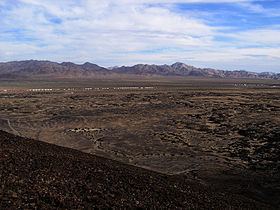
The Bristol Mountains are found in the Mojave Desert of California, USA, just west of Mojave National Preserve. The range, which reaches an elevation of 3,874 feet (1,181 m), is located in San Bernardino County, and crosses Interstate 40 between Ludlow and the Granite Mountains. At the southern end of the range lies the town of Amboy, the Amboy Crater, and Bristol Dry Lake.
Contents
Map of Bristol Mountains, California, USA
Bristol Mountains Wilderness AreaEdit
Most of the Bristol Mountains is in a Federally designated Wilderness and lies within either the Bristol Mountains Wilderness Area or the Kelso Dunes Wilderness Area.
The remainder of the range is designated for Wilderness status in the proposed California Desert Protection Act of 2010.
Project Carryall, proposed in 1963 by the Atomic Energy Commission, the California Division of Highways (now Caltrans), and the Santa Fe Railway, would have used 22 nuclear explosions to excavate a massive roadcut through the Bristol Mountains in the Mojave Desert, to accommodate construction of Interstate 40 and a new rail line. This project would have been part of Operation Plowshare if not for public opposition.