
District Orkdalen Area rank 185 in Norway Area 594.4 km² Local time Monday 12:16 AM | Demonym(s) Orkdaling Population 11,276 (2010) Official language form Norwegian Language | |
 | ||
Weather 4°C, Wind SW at 18 km/h, 93% Humidity Points of interest Gjesvål, Bryggdalen, Pynten, Fallet, Nebbmelen, Sandbanken | ||
Orkdal is a municipality in Sør-Trøndelag county, Norway. It is part of the Orkdalen region. The administrative centre of the municipality is the city of Orkanger. Other villages in the municipality include Kjøra, Geitastrand, Gjølme, Thamshavn, Fannrem, Vormstad, Svorkmo, and Hoston.
Contents
- Map of Orkdal Norway
- General information
- Name
- Coat of arms
- Churches
- Geography
- Notable residents
- Twin towns Sister cities
- References
Map of Orkdal, Norway
Agriculture plays a significant role in the municipality. The Thamshavnbanen was used to transport ore from Løkken Verk to the port of Thamshavn, and is now a vintage railway. The Fannrem concentration camp was located in Fannrem during World War II. Orkanger is one of the main industrial hubs in central Norway. The industry is mainly located around Grønøra Industrial park. The largest companies are Technip Offshore Norge AS, Reinertsen, Washington Mills and Elkem Thamshavn AS.
General information
Orkdal was established as a municipality on 1 January 1838 (see formannskapsdistrikt). On 1 July 1920, the port of Orkanger (population: 1,715) and the southern district of Orkland (population: 1,760) were separated from Orkdal to form separate municipalities. On 1 January 1963, the municipalities of Orkanger, Orkland, and Geitastrand were merged with Orkdal to form a new, larger municipality of Orkdal.
Name
The Old Norse form of the name was Orkardalr. The first element is the genitive case of the name of the river Ork (now Orklaelva) and the last element is dalr which means "valley" or "dale". Historically, the name was spelled Orkedalen.
Coat-of-arms
The coat-of-arms is from modern times. They were granted on 25 April 1986. They show a silver line on a green background, representing the Orklaelva which runs through fertile Orkdalen valley throughout the municipality. It is also a canting because the name of the municipality is derived from the name of the river.
Churches
The Church of Norway has four parishes (sokn) within the municipality of Orkdal. It is part of the deanery (prosti) of Orkdal and the diocese of Nidaros.
Geography
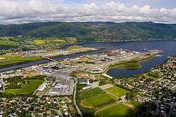
A large part of the population is concentrated in the Orkanger/Fannrem area, which is situated at the head of the Orkdalsfjord, a branch of the large Trondheimsfjord. The Orkla River, one of the better salmon rivers in Norway, meets the sea at Orkanger.
The lakes Hostovatnet, Gangåsvatnet, Våvatnet and Svorksjøen are lakes located around the municipality.
The municipalities of Agdenes, Snillfjord and Hemne lie to the northwest, Rindal (in Møre og Romsdal) and Meldal to the south, and Melhus and Skaun to the east, and Trondheim and Rissa lie to the northeast across the Trondheimsfjord.
Notable residents
Twin towns – Sister cities
Orkdal is twinned with: