
Area 7 km² | Adm. Center Orkanger Merged into Orkdal in 1963 Local time Monday 12:16 AM | |
 | ||
Weather 5°C, Wind SW at 18 km/h, 93% Humidity | ||
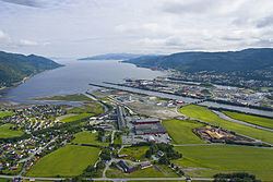
Orkanger is a city and a former municipality in Sør-Trøndelag county, Norway. It is located in the present-day municipality of Orkdal at the end of the Orkdalsfjorden, and arm of the Trondheimsfjord. Orkanger is the administrative and commercial centre of the municipality of Orkdal. Orkanger Church is located here.
Contents
Map of 7300 Orkanger, Norway
Combined with Fannrem, the conurbation constitutes the second largest urban area in Sør-Trøndelag county after the city of Trondheim, the county capital. The 6.04-square-kilometre (2.33 sq mi) area has a population (2013) of 7,812.
Just north of Orkanger lies the port of Thamshavn. Until 1974, Orkanger had a station on the Thamshavn Line railway with the Thamshavn Station just north of the city. Between 1908 and 1949 there was a steam ship service to Trondheim on the SS Orkla.
History
The municipality of Orkanger was established on 1 July 1920 when it was separated from Orkdal. Initially, it had a population of 1,715. The municipality encompassed the urban area and the surrounding countryside. The municipality encompassed 7 square kilometres (2.7 sq mi). On 1 January 1963, the municipality of Orkanger ceased to exist and it was merged into the larger municipality of Orkdal. Prior to the merger, Orkanger had 2,874 residents.
Name
The name "Orkanger" is composed of the name "Ork", which stems from the lake Orkelsjøen from which the river Orkla runs. The second element of the name (Old Norse: angr) means "narrow fjord".