
Max. width 2 kilometres (1.2 mi) Settlements Hoston Area 3.14 km² Length 3 km Shore length 10.31 km | Max. length 3 kilometres (1.9 mi) Surface area 3.14 km (1.21 sq mi) Surface elevation 199 m Mean depth 8 m Width 2 km | |
 | ||
Location Orkdal and Meldal, Sør-Trøndelag | ||
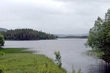
Hostovatnet is a lake on the border of the municipalities of Orkdal and Meldal in Sør-Trøndelag county, Norway. The village of Hoston is located on the northeastern shore of the 3.14-square-kilometre (780-acre) lake.
Map of Hostovatnet, 7320 Fannrem, Norway
The water leaves the lake primarily through the river Vorma which flows east to Vormstad where it joins the Orkla River. The lake Gangåsvatnet lies about 7 kilometres (4.3 mi) to the north. At the southern tip of Hostovatnet there is a short connection to the lake Ringavatnet. The lake is good for fishing trout and Arctic char.
References
Hostovatnet Wikipedia(Text) CC BY-SA