
Length 560.2 km | Constructed 24 August 1924 | |
 | ||
Existed: August 24, 1924 – present | ||
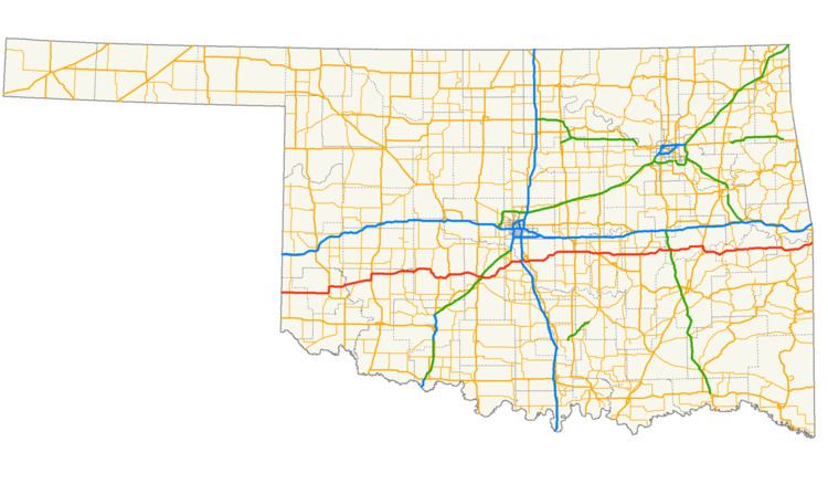
State Highway 9, abbreviated as SH-9, OK-9, or simply Highway 9, is a major east–west highway in the U.S. state of Oklahoma. Spanning across the central part of the state, SH-9 begins at the Texas state line near Madge, Oklahoma, and ends at the Arkansas state line near Fort Smith, Arkansas. State Highway 9 is a major highway around the Norman area. At 348.1 miles (560.2 km), SH-9 is Oklahoma's second-longest state highway (second to State Highway 3).
Contents
Map of OK-9, Oklahoma, USA
West of Interstate 35
From the western terminus at State Highway 203 along the Texas border, the highway travels due east for five miles (8.0 km) and intersects with SH-30 between Madge and Vinson. SH-9 continues east for 23 miles (37 km) without intersecting another highway until meeting US-283 and SH-34 two miles (3.2 km) north of Mangum. The highway overlaps the other two routes for four miles (6.4 km), going north, before splitting off and heading east again through Granite and Lone Wolf. East of Lone Wolf, the highway forms a concurrency with SH-44. Near Hobart, SH-9 overlaps US-183 for 4 miles (6.4 km)(again going northward) before splitting off again.
Continuing east, SH-9 passes through Gotebo, Mountain View, and Carnegie. Around Fort Cobb, Oklahoma, the highway begins nine miles (14 km) of travel to the south. There, the route links up with the concurrent U.S. Highways 62 and 281. While US-281 will split off in Anadarko, SH-9 and US-62 remain concurrent until Newcastle. In Chickasha, US-277 joins to form another three-route concurrency with US-62 and SH-9. On the eastern edge of Chickasha, US-62/277/SH-9 have an interchange with I-44, or more commonly known as the H.E. Bailey Turnpike.
Traveling northeast from Chickasha, US-62/277/SH-9 are routed to the town of Blanchard. Four miles later, SH-9 splits away from the two U.S. routes at a diamond interchange that also serves as the eastern terminus of the H.E. Bailey Turnpike Spur. SH-9 remains without any concurrent routes until Goldsby. The section of road east of US-62/277, recently upgraded to a four-lane divided highway, provides a link from the H.E. Bailey Turnpike Spur to Interstate 35. At the interstate, SH-9 merges onto I-35 northbound to cross the Canadian River into Norman.
East of Interstate 35
Through Norman, Highway 9 serves as a major artery providing access to the University of Oklahoma campus (in particular, the Lloyd Noble Center). Around the area, the route is a four-lane divided expressway (with surface crossings and stoplights). However, after a full interchange with US-77, the road becomes a two lane highway again.
SH-9 continues eastward, passing Lake Thunderbird State Park, before reaching the towns of Tecumseh and Seminole. The road intersects the Indian Nation Turnpike near Hanna, and US-69 near Eufaula. SH-9 provides access to the south side of Lake Eufaula before reaching Stigler.
SH-9 overlaps US-59 for 5 miles (8.0 km), after which the road becomes concurrent with US-271. Both remain concurrent, until the highway ends at the Arkansas border. After passing the Arkansas state line, State Highway 9 becomes I-540, and US-271 continues over the state line concurrent with the Interstate.
History
Officially designated on 1924-08-24, the original route encompassed all of current SH-9 west of Blanchard. East of Blanchard, SH-9 followed a more northerly route. Bypassing Norman, SH-9 ran north to Oklahoma City before going east through Harrah, Meeker, Prague, Henryetta, and Checotah. The highway ended at the original State Highway 3 in Spiro. Upon the creation of the United States Numbered Routes system in 1926, the section between Oklahoma City and Warner was overlaid with U.S. Highway 266. Four years later in 1930, SH-9 was truncated to Chickasha. By this time, much of the route had become part of U.S. Highway 62.
On 1935-08-27, the route was extended eastward, taking over the original SH-37. SH-9's eastern terminus became SH-48 near Seminole. On 1937-08-25, the route was brought further east to end at US-69 in Eufaula. Part of the newly commissioned section was rescinded on 1937-10-19, when a small segment just east of SH-48 and the entire Hughes County portion were dropped from the highway. These sections were re-added on 1938-09-27.
State Highway 9 was extended eastward twice in the route's history. The first extension occurred on 1941-02-26, and extended SH-9 to SH-2 at Whitefield. The final extension brought SH-9 to the Arkansas state line on 1941-11-12. The only major realignment in SH-9's history since 1941 was the Norman expressway bypass, which was designated as SH-9 on 1971-11-08.
After the I-40 bridge disaster, parts of State Highway 9 in eastern Oklahoma served as an emergency detour for eastbound I-40 traffic. All eastbound traffic was routed along the section of SH-9 between SH-2 in Whitefield and US-59. In addition, the section of SH-9 between US-59 and the Arkansas state line were used for eastbound traffic for commercial trucks.
Future
Discussions are under way to widen SH-9 to four lanes east of US-77 in Norman. The City of Norman and ODOT have conflict in their proposals for the design of the widened highway. ODOT has proposed a 16-foot (4.9 m) paved median, with 12-foot (3.7 m) shoulders to accommodate bicyclists. Norman's proposal includes a grass median and a separate bike path along the north side of the right-of-way, running from 24th Avenue S.E. to Lake Thunderbird. ODOT criticized the city's plan as too expensive. The city is now proposing a compromise, with a narrower raised concrete median and separate bike path.
Spurs
State Highway 9 creates three spur highways throughout the state. Additionally, it has two business routes, serving towns the main route bypasses. These routes are: