
NRHP Reference # 66000607 Area 9.9 ha Added to NRHP 13 November 1966 | Designated NHLD November 13, 1966 Year built 1825 | |
 | ||
Similar Ohio and Erie Canal Towpath, Erie Canal, Cuyahoga Valley Scenic R, Cuyahoga River, Miami and Erie Canal | ||
The Ohio and Erie Canal was a canal constructed in the 1820s and early 1830s in the U.S. state of Ohio. It connected Akron, Summit County, with the Cuyahoga River near its mouth on Lake Erie in Cleveland, Cuyahoga County, and a few years later, with the Ohio River near Portsmouth, Scioto County, and then connections to other canal systems in Pennsylvania.
Contents
- History
- Agitation for a canal system 17871822
- Survey and design 1822
- Construction 182532
- Operation 18331913
- Abandonment
- Notable persons associated with the Canal
- The Canal today
- Points of interest
- Connecting canals
- Towpath Trail landmarks
- References
The canal carried freight traffic from 1827 to 1861, when the arrival of railroads killed the market. From 1862 to 1913, the canal served as a water source to industries and towns. In 1913, much of the canal system was abandoned after important parts were severely flooded.
Today, most of the remaining portions are managed by the National Park Service or Ohio Department of Natural Resources. They are used for various recreational purposes by the public, and still provide water for some industries. Parts of the canal are preserved, including the Ohio and Erie Canal Historic District, a National Historic Landmark.
History
Ohio, which achieved statehood in 1803, remained a sparsely populated region of 50,000 persons who were scattered throughout the state and who had no means of economically transporting goods. With no easy access to distant markets, agriculture served only local needs and large-scale manufacturing was nearly non-existent.
Agitation for a canal system (1787–1822)
As early as 1787, George Washington and Thomas Jefferson had discussed the desirability of a canal linking Lake Erie to the Ohio River as part of a national system of canals. It wasn't until 1807 that Ohio's first Senator, Thomas Worthington offered a resolution in Congress asking Treasury Secretary Albert Gallatin to report to the Senate. In 1810, DeWitt Clinton was appointed to head the Erie Canal Commission. He was unsuccessful in his attempt to get national aid for the construction of a canal connecting Lake Erie to the Hudson River, so he enlisted the aid of state legislators and Ohio's congressional delegation. On January 15, 1812 the Ohio General Assembly passed a resolution expressing its view that the connection of the Great Lakes with the Hudson River was a project of "national concern". President Madison was against the proposal, however, and the War of 1812 ended all discussion.
On December 11, 1816, Clinton, by then the Governor of New York, sent a letter to the Ohio Legislature indicating his state's willingness to construct the Erie Canal without national help, and asking the State of Ohio to join in the endeavor. On January 9, 1817, the Ohio Legislature directed Ohio's Governor (and former Senator) Thomas Worthington to negotiate a deal with Clinton. Due to the cost, however, the Ohio Legislature dallied, and nothing happened for the next 3 years. Finally, in January 1822, in a fit of progressivism, the Ohio Legislature passed acts to fund the canal system and the state's public education obligations.
Survey and design (1822)
On January 31, 1822 the Ohio Legislature passed a resolution to employ an engineer and appoint commissioners to survey and design the canal system as soon as possible. A sum not to exceed $6000 was set aside for this purpose.
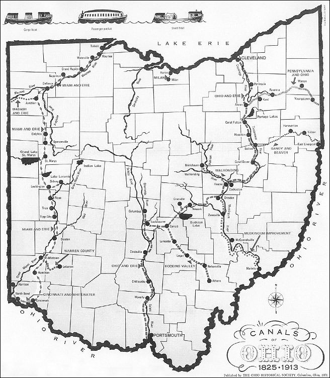
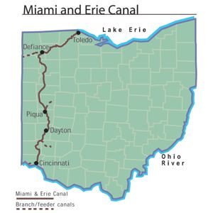
James Geddes, an engineer whose past work included experience on the New York canals, was employed. Since most of Ohio's population lived along a line from Cleveland to Cincinnati, it was necessary that these areas be served by the main trunk of the canal. Since canals must generally follow river valleys, it was difficult to design a suitable system. Specifically, the bridging of the Scioto and Miami river valleys required raising the canal to such an elevation that water from neither river could be used as a source. As a result, the canal was divided into two sections, the Ohio and Erie Canal from Cleveland to Portsmouth which crossed the Licking Divide and followed the Scioto River Valley, and the Miami and Erie Canal which connected Cincinnati to Dayton. In later years this second canal would be extended all the way to the Maumee River at Toledo.
Copies of the original survey plat maps for the construction of both Ohio canals are available on-line from the Ohio Department of Natural Resources.
Construction (1825–32)
On February 4, 1825, the Ohio Legislature passed "An Act to provide for the Internal Improvement of the State of Ohio by Navigable Canals". The Canal Commission was authorized to borrow $400,000 in 1825, and not more than $600,000 per year thereafter. The notes issued were to be redeemable between 1850 and 1875.
On July 4, 1825, ground was broken on the canal at Licking Summit near Newark, Ohio.
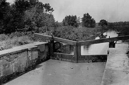
The canals were specified to have a minimum width of 40 feet (12 m) at the top, 26 feet (8 m) at the bottom, and a depth of 4 feet (1.2 m) feet minimum. These limits were often exceeded, and indeed it was cheaper to do so in most cases. For example, it might be cheaper to build one embankment and then let the water fill all the way to the adjacent foothills, perhaps hundreds of feet away, rather than build two embankments. By damming the rivers, long stretches of slackwater could be created which, with the addition of towpaths, could serve as portions of the canal. Where it made economic sense to do so, such as lock widths or portions of the canal through narrow rock or across aqueducts, the minimum widths were adhered to.
Contracts were let for the following tasks:
Initially, contractors in general proved to be inexperienced and unreliable. It was common for one job to receive 50 bids, many of them local to where the work was being performed. The chosen contractor, having underbid the contract, often would vanish in the night leaving his labor force unpaid and his contract unfulfilled. This problem was so bad that laborers refused to perform canal work for fear of not being paid. As the bidding process was improved, and more reliable contractors engaged, the situation improved.
Workers were initially paid $0.30 per day and offered a jigger of whiskey. As work progressed, and where labor was in shortage, workers could make as much as $15 per month. At that time, cash money was hard to come by in Ohio forcing much bartering. Working on the canal was appealing and attracted many farmers from their land.
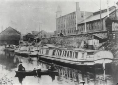
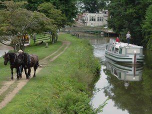
On July 3, 1827 the first canal boat on the Ohio and Erie Canal left Akron, traveled through 41 locks and over 3 aqueducts along 37 miles (60 km) of canal, to arrive at Cleveland on July 4. While the average speed of 3 mph (4.8 km/h) may seem slow, canal boats could carry 10 tons of goods and were much more efficient than wagons over rutted trails.
Over the next five years, more and more portions of the canal opened, with it finally being completed in 1832:
In 1832, the Ohio and Erie Canal was completed. The entire canal system was 308 miles (496 km) long with 146 lift locks and a rise of 1,206 feet (368 m). In addition, there were five feeder canals that added 24.8 miles (39.9 km) and 6 additional locks to the system consisting of:
The canal's lock numbering system was oriented from the Lower Basin, near the southwest corner of the current Exchange and Main streets in Akron. North of the basin is Lock 1 North, and south of the basin is Lock 1 South. At this basin was the joining of the Pennsylvania and Ohio Canal.
Operation (1833–1913)
The canals enjoyed a golden period of prosperity from the 1830s to the early 1860s, with a peak in revenue between 1852 and 1855. During the 1840s, Ohio was the third most prosperous state, owing much of that growth to the canal. Immediately following the Civil War, it became apparent that railroads would take the canal's business. From 1861 until 1879, after the canal had been badly flooded, Ohio leased its canals to private owners who earned revenue from dwindling boat operation and the sale of water to factories and towns. When the state took the canals back in 1879, it discovered that they had not been maintained, and that state lands surrounding the canals had been illegally sold to private owners. In many cases, canals were filled in for "health reasons," only to find a newly laid railroad track on their right of way. Much State land was given away for free to politically savvy private owners. Nevertheless, some revenue was accrued into the early twentieth century from the sale of water rights as well as recovery and sale of land surrounding the canals.
Abandonment
After the peak of the 1850s and a bottoming out of revenue due to the Civil War in the early 1860s the canal's expenditures started to outgrow its revenues due to rising maintenance costs. By 1911, most of the southern portion of the canal had been abandoned. On March 23, 1913, after a winter of record snowfall, storms dumped an abnormally heavy amount of rain on the state, causing extensive flooding. This caused the reservoirs to spill over into the canals, destroying aqueducts, washing out banks, and devastating most of the locks. In Akron, Lock 1 was dynamited to allow backed up floodwater to flow.
Notable persons associated with the Canal
The Canal today
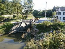
The Ohio and Erie Canal Historic District, a 24.5-acre (99,000 m2) historic district including part of the canal, was declared a National Historic Landmark in 1966. It is a four-mile (6 km) section within the village of Valley View comprising three locks, the Tinkers Creek Aqueduct, and two other structures.
A remaining watered section of the Ohio & Erie Canal is located in Summit County, Ohio. The Ohio & Erie Canal is maintained, to this day, as a water supply for local industries. After the flood, a few sections of the canal continued in use hauling cargo to local industries. Another watered section extends from the Station Road Bridge in Brecksville northwards into Valley View and Independence, all Cleveland suburbs.
The section of the Ohio & Erie Canal from the Brecksville Dam to Rockside Road in Cuyahoga County was transferred to the National Park Service in 1989 as part of the Cuyahoga Valley National Recreational Area (now known as the Cuyahoga Valley National Park).
A lease on the canal lands from the Cuyahoga Valley National Park to the terminus of the canal has been executed with the Cleveland Metroparks. The Metroparks manage the adjacent real estate and the surrounding Ohio & Erie Canal Reservation.
The section of the Ohio & Erie Canal still owned and maintained by the Division of Water in southern Summit is referred to as the watered section. This section runs from the north end of Summit Lake south to Barberton, a distance of about 12 miles (19 km). Included in this section is the feeder canal from the Tuscarawas River and the hydraulics at the Portage Lakes.
The Ohio & Erie Canal is maintained from Akron by a staff of six Division of Water employees. Like its sister canal, the Ohio & Erie Canal carries a large amount of stormwater. The canals were not designed to accommodate this great influx of stormwater. Most of the siltation and erosion problems experienced today are the result of stormwater inappropriately piped into the canals over the years.
In late 1996, the canal from Zoar to Cleveland was designated a National Heritage Corridor. This designation was brought about through the efforts of many communities, civic organizations, businesses and individuals working in partnership. The Department is working with numerous local communities and organizations to assure the continued development of the Ohio & Erie Canal.
A map showing the disposition of the canal lands is available on-line from the Ohio Department of Natural Resources.
Points of interest
Connecting canals
The Ohio and Erie Canal initially provided a connection between Akron and Lake Erie at Cleveland, then extending all the way to the Ohio River within a few years. Later, connecting canal systems were built connecting it with the Pennsylvania and Ohio Canal and other parts of Eastern Ohio.
Towpath Trail landmarks
An all-purpose bicycle/pedestrian trail was constructed by Cuyahoga Valley National Park in Southern Cuyahoga County and Northern Summit County, Cleveland Metroparks in Northern Cuyahoga County, and Akron/Summit County Metroparks in Southern Summit County to roughly follow the original Ohio and Erie Canal Towpath route. (The northernmost section in Cuyahoga County is still undergoing construction.) There are many connecting trails going to other points of interest throughout their park systems.
Please help by expanding this section with any notable landmarks along the Ohio and Erie Canal Towpath Trail.
Travels through Cuyahoga, Summit, Stark, Licking, Franklin, Fairfield, Pickaway, and Scioto counties.