
Length 137 km | Country United States of America | |
 | ||
Main source 1,093 feet (333.1 m) Confluence ofEast Branch Cuyahoga River andWest Branch Cuyahoga Rivernear Pond Road and Rapids Road, Burton, Geauga County, Ohio Basin size 809 square miles (2,100 km) Sources West Branch Cuyahoga River, East Branch Cuyahoga River Bridges Detroit–Superior Bridge, Hope Memorial Bridge Similar Lake Erie, Whiskey Island, Ohio and Erie Canal, Cuyahoga Valley Scenic R, Kent State University | ||
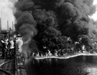
Cuyahoga river pollution ohio 1967
The Cuyahoga River (/ˌkaɪ.əˈhɒɡə/ KY-ə-HOG-ə, or /ˌkaɪ.əˈhoʊɡə/ KY-ə-HOH-gə) is a river in the United States, located in Northeast Ohio, that feeds into Lake Erie. The river is famous for having been so polluted that it "caught fire" in 1969. The event helped to spur the environmental movement in the US.
Contents
- Cuyahoga river pollution ohio 1967
- Map of Cuyahoga River Ohio USA
- Cuyahoga river burning 1969 my experience
- EtymologyEdit
- CourseEdit
- HistoryEdit
- Environmental concernsEdit
- ModificationsEdit
- Ice breakingEdit
- FloodingEdit
- Ohio and Erie Canal diversion damEdit
- Gorge Metropolitan Park DamEdit
- Dams in Cuyahoga FallsEdit
- Munroe Falls DamEdit
- Kent DamEdit
- Variant namesEdit
- TributariesEdit
- References
Map of Cuyahoga River, Ohio, USA
Cuyahoga river burning 1969 my experience
EtymologyEdit
The name Cuyahoga is believed to mean "crooked river" from the Mohawk Indian name Cayagaga, although the Senecas called it Cuyohaga, or "place of the jawbone".
CourseEdit
The Cuyahoga watershed begins its 100-mile (160 km) journey in Hambden, Ohio, flowing southward to the confluence of the East Branch Cuyahoga River and West Branch Cuyahoga River in Burton, where the Cuyahoga River officially begins. It continues on its 84.9 miles (136.6 km) journey flowing southward to Akron and Cuyahoga Falls, where it turns sharply north and flows through the Cuyahoga Valley National Park in northern Summit County and southern Cuyahoga County. It then flows through Independence, Valley View, Cuyahoga Heights, Newburgh Heights and Cleveland to its northern terminus, emptying into Lake Erie. The Cuyahoga River and its tributaries drain 813 square miles (2,110 km2) of land in portions of six counties.
The river is a relatively recent geological formation, formed by the advance and retreat of ice sheets during the last ice age. The final glacial retreat, which occurred 10,000–12,000 years ago, caused changes in the drainage pattern near Akron. This change in pattern caused the originally south-flowing Cuyahoga to flow to the north. As its newly reversed currents flowed toward Lake Erie, the river carved its way around glacial debris left by the receding ice sheet, resulting in the river's winding U-shape. These meanderings stretched the length of the river (which was only 30 miles (50 km) when traveled directly) into a 100-mile (160 km) trek from its headwaters to its mouth. The depth of the river (except where noted below) ranges from 3 to 6 ft (1 to 2 m).
HistoryEdit
Moses Cleaveland, a surveyor charged with exploring the Connecticut Western Reserve, first arrived at the mouth of the Cuyahoga in 1796 and subsequently located a settlement there, which became Cleveland, Ohio.
The river was one of the features along which the "Greenville Treaty Line" ran beginning in 1795, per the Treaty of Greenville that ended the Northwest Indian War in the Ohio Country, effectively becoming the western boundary of the United States and remaining so briefly.
Environmental concernsEdit
The Cuyahoga River, at times during the 20th century, was one of the most polluted rivers in the United States. The reach from Akron to Cleveland was devoid of fish. A 1968 Kent State University symposium described one section of the river:
From 1,000 feet [300 m] below Lower Harvard Bridge to Newburgh and South Shore Railroad Bridge, the channel becomes wider and deeper and the level is controlled by Lake Erie. Downstream of the railroad bridge to the harbor, the depth is held constant by dredging, and the width is maintained by piling along both banks. The surface is covered with the brown oily film observed upstream as far as the Southerly Plant effluent. In addition, large quantities of black heavy oil floating in slicks, sometimes several inches thick, are observed frequently. Debris and trash are commonly caught up in these slicks forming an unsightly floating mess. Anaerobic action is common as the dissolved oxygen is seldom above a fraction of a part per million. The discharge of cooling water increases the temperature by 10 to 15 °F [5.6 to 8.3 °C]. The velocity is negligible, and sludge accumulates on the bottom. Animal life does not exist. Only the algae Oscillatoria grows along the piers above the water line. The color changes from gray-brown to rusty brown as the river proceeds downstream. Transparency is less than 0.5 feet [0.15 m] in this reach. This entire reach is grossly polluted.
At least 13 fires have been reported on the Cuyahoga River, the first occurring in 1868. The largest river fire in 1952 caused over $1 million in damage to boats, a bridge, and a riverfront office building. On June 22, 1969, a river fire captured the attention of Time magazine, which described the Cuyahoga as the river that "oozes rather than flows" and in which a person "does not drown but decays". The fire did eventually spark major changes as well as the article from Time, but in the immediate aftermath very little attention was given to the incident and it was not considered a major news story in the Cleveland media. Furthermore, the conflagration that sparked Time's outrage was in June 1969, but the pictures they displayed on the cover and as part of the article were from the much more dangerous and costly 1952 fire. No pictures of the 1969 fire are known to exist, as local media did not arrive on the scene until after the fire was under control. The 1969 fire caused approximately $50,000 in damage, mostly to an adjacent railroad bridge.
The 1969 Cuyahoga River fire helped spur an avalanche of water pollution control activities, resulting in the Clean Water Act, Great Lakes Water Quality Agreement, and the creation of the federal Environmental Protection Agency and the Ohio Environmental Protection Agency (OEPA). As a result, large point sources of pollution on the Cuyahoga have received significant attention from the OEPA in recent decades. These events are referred to in Randy Newman's 1972 song "Burn On," R.E.M.'s 1986 song "Cuyahoga," and Adam Again's 1992 song "River on Fire." Great Lakes Brewing Company of Cleveland named its Burning River Pale Ale after the event.
Water quality has improved and, partially in recognition of this improvement, the Cuyahoga was designated one of 14 American Heritage Rivers in 1998. Despite these efforts, pollution continues to exist in the Cuyahoga River due to other sources of pollution, including urban runoff, nonpoint source problems, combined sewer overflows, and stagnation due to water impounded by dams. For this reason, the Environmental Protection Agency classified portions of the Cuyahoga River watershed as one of 43 Great Lakes Areas of Concern. The most polluted portions of the river now generally meet established aquatic life water quality standards except near dam impoundments. The reasons for not meeting standards near the dam pools are habitat and fish passage issues rather than water quality. River reaches that were once devoid of fish now support 44 species. The most recent survey in 2008 revealed the two most common species in the river were hogsuckers and spotfin shiners, both moderately sensitive to water quality. Habitat issues within the 5.6 miles (9.0 km) navigation channel still preclude a robust fishery in that reach. Recreation water quality standards (using bacteria as indicators) are generally met during dry weather conditions, but are often exceeded during significant rains due to nonpoint sources and combined sewer overflows.
ModificationsEdit
The lower Cuyahoga River has been subjected to numerous changes. Originally, the Cuyahoga river met Lake Erie approximately 4,000 feet (1.2 km) west of its current mouth, forming a shallow marsh. The current mouth is man-made, and it lies just west of present-day downtown Cleveland, which allows shipping traffic to flow freely between the river and the lake. Additionally, the U.S. Army Corps of Engineers periodically dredges the navigation channel of the otherwise shallow river to a depth of 27 feet (8.2 m), along the river's lower 5 miles (8.0 km), from its mouth up to the Mittal Steel Cleveland Works steel mills, to accommodate Great Lakes freighter traffic which serves the bulk (asphalt, gravel, petroleum, salt, steel, and other) industries located along the lower Cuyahoga River banks in Cleveland's Flats district. The Corps of Engineers has also straightened river banks and widened turning basins in the Federal Navigation Channel on the lower Cuyahoga River to facilitate maritime operations.
Ice-breakingEdit
The United States Coast Guard sometimes conducts fall and spring ice-breaking operations along Lake Erie and the lower Cuyahoga River to prolong the Great Lakes shipping season, depending on shipping schedules and weather conditions.
FloodingEdit
Some attempts (including dams and dredging) have been made to control flooding along the Cuyahoga River basin. As a result of speculative land development, buildings have been erected on many flat areas that are only a few feet above normal river levels. Sudden strong rain or snow storms can create severe flooding in these low-lying areas.
The upper Cuyahoga River, starting at 1,093 feet (333 m) over 84 miles (135 km) from its mouth, drops in elevation fairly steeply, creating falls and rapids in some places; the lower Cuyahoga River only drops several feet along the last several miles of the lower river to 571 feet (174 m) at the mouth on Lake Erie, resulting in relatively slow-moving waters that can take a while to drain compared to the upper Cuyahoga.
Some tributary elevations above are higher than the Cuyahoga River elevation, because of small waterfalls at or near their confluences; and distances are measured in "river miles" along the river's length from its mouth on Lake Erie.
Ohio and Erie Canal diversion damEdit
The Brecksville Dam at river mile 20 is the first dam upstream of Lake Erie. It affects fish populations by restricting their passage. The EPA is currently attempting to shut down and remove the dam.
Gorge Metropolitan Park DamEdit
The largest dam is the Gorge Metropolitan Park Dam, also known as the FirstEnergy Dam, on the border between Cuyahoga Falls and Akron. This 57-foot dam has for over 90 years submerged the falls for which the City of Cuyahoga Falls was named; more to the point of water quality, it has created a large stagnant pool with low dissolved oxygen.
The FirstEnergy Dam was built by the Northern Ohio Traction and Light Co. in 1912 to serve the dual functions of generating hydropower for its local streetcar system and providing cooling-water storage for a coal-burning power plant; however, the hydropower operation was discontinued in 1958, and the coal-burning plant was decommissioned in 1991. Some environmental groups and recreational groups want the dam removed. Others contend such an effort would be expensive and complicated, for at least two reasons: first, the formerly hollow dam was filled in with concrete in the early 1990s, and second, because of the industrial history of Cuyahoga Falls, the sediment upstream of the dam is expected to contain hazardous chemicals, possibly including heavy metals and PCBs. The Ohio EPA estimated removal of the dam would cost $5–10 million, and removal of the contaminated sediments $60 million. The dam is licensed through 2041.
Advanced Hydro Solutions (AHS), a company based in Fairlawn, Ohio, filed a notice of intent to use the dam to generate hydropower. The company contends hydropower is a cleaner source of power and the emissions saved by the plant will be the equivalent of taking 10,000 cars off the road. Citing concerns with erosion, dewatering of the scenic river reach below the dam, and use that is inconsistent with the Gorge MetroPark's purpose, opponents to this plan include, in addition to environmental and recreational groups, some governmental agencies, including Summit Metro Parks, the U.S. Department of the Interior, and the Ohio EPA. At public meetings held on July 27, 2005, the proposed project, which would generate enough electricity to power 2000 homes, encountered substantial opposition. On May 25, 2007, AHS suffered a setback in its effort to develop the site. The United States Court of Appeals for the sixth circuit denied its application to conduct tests at the site, refusing to overturn a lower court's ruling that the MetroParks had the right to deny AHS access to conduct the tests. In a letter dated June 14, 2007, the Federal Energy Regulatory Commission (FERC) terminated AHS's application for the Integrated Licensing Permit without prejudice, citing the company's failure to adhere to strict timelines. FERC will allow AHS to refile if it can conduct the required studies and move forward with the project. The final decision from the FERC on the project was due in July 2009. On June 12, 2009, AHS dropped its permit and terminated the project.
Dams in Cuyahoga FallsEdit
Two dams in Cuyahoga Falls, the Sheraton and LeFever Dams, were scheduled for demolition in late 2012. This is the result of an agreement between the City of Cuyahoga Falls, which owns the dams, and the Northeast Ohio Regional Sewer District, which will provide $1 million of funding to remove the dams. This schedule was delayed, in part because of complications with the bidding process, and because of requirements from the Army Corps of Engineers. On December 12, 2012, the ACOE issued a permit, allowing the demolition to proceed. As part of the project, a water trail will be developed. In early June, 2013, dam removal began, and ended in July, 2013. This will bring about a mile of the river back to its natural state, remove 35 feet of structures, and expose an equivalent quantity of whitewater for recreation. As of August 20, 2013, both small dams had effectively been totally removed, and there is essentially no impoundment of water now. Cleanup and remediation of the general area within downtown Cuyahoga Falls remains to be completed.
Munroe Falls DamEdit
Two other dams, in Kent and in Munroe Falls, though smaller, have had an even greater impact on water quality due to the lower gradient in their respective reaches. For this reason, the Ohio EPA required the communities to mitigate the effects of the dams.
The Munroe Falls Dam was modified in 2005. Work on this project uncovered a natural waterfall. Given this new knowledge about the riverbed, some interested parties, including Summit County, campaigned for complete removal of the dam. The revised plan, initially denied on September 20, 2005, was approved by the Munroe Falls City Council on a week later. The 11.5 foot sandstone dam has since been removed, and in its place now is a natural ledge with a 4.5 foot drop at its greatest point.
Kent DamEdit
The Kent Dam was bypassed in 2004.
Variant namesEdit
According to the United States Geological Survey Geographic Names Information System, the Cuyahoga River has also been known as:
TributariesEdit
Generally, rivers are larger than creeks, which are larger than brooks, which are larger than runs. Runs may be dry except during or after a rain, at which point they can flash flood and be torrential.
Default is standard order from mouth to upstream: