
Length 372 km | Discharge 189 m³/s | |
 | ||
Main source Near New Hampshire, Ohio Basin size 6,517 sq mi (16,880 km) Bridges Main Street Bridge, Caledonia Bowstring Bridge | ||
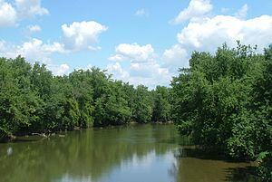
The Scioto River (/saɪˈoʊtoʊ/ sy-OH-toh or /saɪˈoʊtə/ sy-OH-tə) is a river in central and southern Ohio more than 231 miles (372 km) in length. It rises in Auglaize County in west central Ohio, flows through Columbus, Ohio, where it collects its largest tributary, the Olentangy River, and meets the Ohio River at Portsmouth. Too small for modern commercial shipping, its primary economic importance is for recreation and drinking water.
Contents
- Map of Scioto River Ohio USA
- Lewis claim gold on the scioto river ohio gpaa gold prospectors association of america
- Geography and geology
- History
- Pollution
- Dams and reservoirs
- Cities and towns along the Scioto River
- Variant names
- References
Map of Scioto River, Ohio, USA
Lewis claim gold on the scioto river ohio gpaa gold prospectors association of america
Geography and geology
The lower Scioto River valley is large compared to the width of the river and is extensively farmed. Meltwaters from retreating glaciers carved the valley exceptionally wide. Valley bottoms are smooth, and flood deposits created during and since the most recent Glacial period cause floodplain soils to be very productive. As a result, farms line much of the lower Scioto where it flows through low, rolling hills covered in hardwood trees.
The geologic history of the Scioto River is tied to the destruction of the Teays River network during the Ice Ages and consequent creation of the Ohio River. The north flowing Teays River was dammed by glaciers, and damming of other rivers led to a series of floods as lakes overflowed into adjacent valleys. Glacial Lake Tight is estimated to have been two-thirds the size of modern Lake Erie. Valleys beyond the reach of glaciers were reorganized to create the Ohio River, and the Scioto River replaced the Teays River. The Scioto River flows through segments of the Teays River valley but opposite the direction the Teays River flowed. In the cities of Columbus and Dublin, the river has cut a gorge in fossil-bearing Devonian limestone, and many tributary streams have waterfalls, such as Hayden Falls.
History
The Scioto River valley was home to many Native American cultures. The best known group is the Mound Builders of the Hopewell tradition. Numerous burial mounds can be seen near Chillicothe at the Hopewell Culture National Historic Park. The former strength of these cultures is demonstrated in settler accounts from as far east as Virginia. The name Scioto is derived from the Wyandot word skɛnǫ·tǫ’ 'deer' (compare Shenandoah, derived from the word for deer in another Iroquoian language.
During the antebellum years, the Scioto River provided a route to freedom for many slaves escaping from the South, as they continued north after crossing the Ohio River. Towns such as Chillicothe became important stops on the Underground Railroad.
A traditional fiddle tune in the Appalachian repertoire, “Big Scioty”, takes its name from the river. The melody is attributed to the Hammons family of West Virginia.
In 2012, the river dropped to record- or near-record-low water levels as a result of the acute effects of the 2012 North American drought in Ohio.
Pollution
Threats facing the river include agricultural pollutants from upstream and urban-generated pollutants such as contaminated street runoff and waterborne litter. Rapid residential and commercial development in the watershed is increasing stormwater runoff.
Dams and reservoirs
There are two major dams on the river. Griggs Dam in Columbus was built in 1904–1908 to impound a water supply for the city. Farther upstream, at Shawnee Hills, the O'Shaughnessy Dam was built in 1922–1925 creating a larger reservoir which was billed at the time as "the finest inland waterway in the United States." Both dams are operated by the city of Columbus.
The removal of the Main Street Dam in downtown Columbus, which was built in 1921, began in November 2013. The removal was initially proposed in the 2010 Strategic Plan for downtown Columbus; the $35.5 million project is being funded by a coalition of public and private entities, including the City of Columbus, Mid-Ohio Regional Planning Commission, Ohio Department of Transportation, Ohio Environmental Protection Agency, U.S. Environmental Protection Agency, Columbus Downtown Development Corporation, Franklin County Board of Commissioners, Metro Parks, The Columbus Foundation, and Battelle.
Prior to its demolition, the Main Street Dam impounded roughly 2.3 miles (3.7 km) of the Scioto River, artificially enlarging its width to an average of 500 feet (150 m) in downtown Columbus. Once completed, the Scioto Greenways project will reduce the width by nearly half, and expose 33 acres (13 ha) of land which will be reclaimed as parkland by the city. Riffles and pools will be restored to the river channel, returning it to its natural riparian state. Experts believe the restoration project will result in a healthier river and better habitat for native plant, fish, and mussel species.
Cities and towns along the Scioto River
Cities and towns, listed from upstream to downstream:
Variant names
According to the Geographic Names Information System, the Scioto River has also been known as: