Trisha Shetty (Editor)

Ohio State Route 5

Updated on
Edit
Like
Comment
Share on FacebookTweet on TwitterShare on LinkedInShare on Reddit
Existed:
  
1932 – present

Constructed
  
1932

East end:
  
PA 58 near Kinsman

Length
  
81.93 km

Ohio State Route 5

West end:
  
I-76 / SR 44 near Ravenna

Counties
  
Portage County, Ohio, Trumbull County, Ohio

Ohio state route 555 part 2 of 4 very twisty


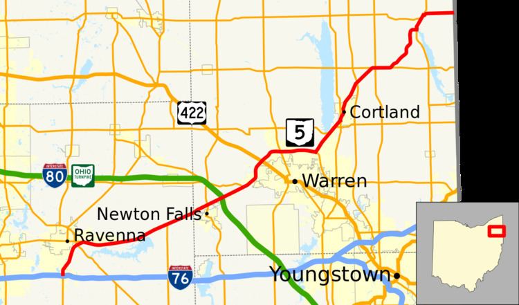
State Route 5 (SR 5) is an east–west state highway in the northeastern portion of the U.S. state of Ohio. Its western terminus is at Interstate 76 at its interchange with State Route 44 about 3.5 miles (5.6 km) south of Ravenna, and its eastern terminus is at the Pennsylvania state line northeast of Kinsman; this point is also the western terminus of Pennsylvania Route 58 which begins to the east.

Contents

History

  • 1932 – Current route established; originally routed along the former State Route 36 from Wooster to the Pennsylvania state line along current State Route 585, State Route 59, its current routing east of Ravenna, and a currently unnumbered road through Akron.
  • unknown – Realigned from 4 miles (6.4 km) northeast of Warren to Cortland.
  • 1969 – Western terminus moved to 3½ south of Ravenna, and routed along new bypass route to 3 miles (4.8 km) east of Ravenna; former alignment from Wooster to State Route 21 certified as State Route 585; former alignment from 3 miles (4.8 km) south of Cuyahoga Falls to 3 miles (4.8 km) east of Ravenna certified as State Route 59.
  • unknown – Realigned from 3 miles (4.8 km) east of Ravenna to 7 miles (11 km) west of Warren.
  • 1970 – Warren Bypass completed from U.S. Route 422 to 3 miles (4.8 km) northeast of Warren (Elm Road) and certified as State Route 5B.
  • 1971 – Warren Bypass extended to 3 miles (4.8 km) west of Warren; entire bypass certified as State Route 5 (State Route 5B designation removed).
  • 1978 – Warren Bypass upgraded to freeway.
  • Before 1932

  • 1924 – Original route established; originally routed from the Indiana state line 14 miles (23 km) west of Van Wert to the Pennsylvania state line 6 miles (9.7 km) east of East Liverpool along the current U.S. Route 30 from Indiana to Mansfield, current U.S. Route 42 from Mansfield to Ashland, current U.S. Route 250 from Ashland to 5 miles (8.0 km) west of Wooster, U.S. Route 30 from 5 miles (8.0 km) west of Wooster to 2 miles (3.2 km) east of Dalton, State Route 172 from 2 miles (3.2 km) east of Dalton to Waco, U.S. Route 30 from Waco to East Liverpool, and State Route 39 from East Liverpool to Pennsylvania.
  • 1926 – Truncated at Delphos and 5 miles (8.0 km) west of Wooster; Indiana to Delphos and 5 miles (8.0 km) west of Wooster to East Liverpool certified as U.S. Route 30; East Liverpool to Pennsylvania certified as State Route 39; Mansfield to Ashland dually certified as U.S. Route 42 and State Route 5; Ashland to 5 miles (8.0 km) west of Wooster dually certified as State Routes 5 and 6.
  • 1929 – State Route 5 dual certification removed from U.S. Route 42 and State Route 6.
  • 1932 – Delphos to Mansfield certified as U.S. Route 30N.
  • References

    Ohio State Route 5 Wikipedia