
Admin. region Freiburg Elevation 506 m (1,660 ft) Area 55.93 km² Local time Wednesday 4:00 AM Dialling code 07423 | Time zone CET/CEST (UTC+1/+2) Population 14,641 (31 Dec 2008) Postal code 78727 Administrative region Freiburg | |
 | ||
Weather 2°C, Wind N at 11 km/h, 94% Humidity | ||
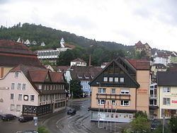
Street view oberndorf am neckar in germany
Oberndorf am Neckar is a town in the district of Rottweil, in Baden-Württemberg, Germany. It is situated on the river Neckar, 15 kilometres (9 miles) north of Rottweil. It historically was and currently is a major center of the German weapons industry.
Contents
- Street view oberndorf am neckar in germany
- Map of Oberndorf Germany
- Geography
- Neighborhoods
- Culture and sightseeing
- Museums
- Home to
- International relations
- References
Map of Oberndorf, Germany
Geography
Oberndorf lies in the Neckar Valley, which is between the Black Forest and the Swabian Jura. The Autobahn A 81 is nearby, with the Oberndorf exit about halfway between Stuttgart and Konstanz. The train line Stuttgart-Zürich-Milan goes directly through Oberndorf as well.
Neighborhoods
The city of Oberndorf am Neckar is made up of the city proper and the surrounding villages of Altoberndorf, Aistaig, Boll, Bochingen, Beffendorf and Hochmössingen. The formerly independent surrounding villages have been put under the administration of Oberndorf during the village and township reforms of Baden-Württemberg in the early 1970s.
Culture and sightseeing
Aside from the beautiful Black Forest and wonderful German countryside, Oberndorf offers much to see. It is well known for its annual Karneval celebrations, which remain very traditional.
Museums
Home to
International relations
Oberndorf am Neckar is twinned with: