
- elevation 7,018 ft (2,139 m) - average 1,248 cu ft/s (35 m/s) Length 98 km Basin area 1,267 km² | - elevation 1,129 ft (344 m) Discharge 21.24 m³/s Basin area 1,267 km² | |
 | ||
- max 63,400 cu ft/s (1,795 m/s) | ||
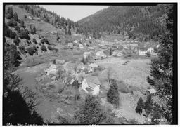
Aerial video over north yuba river downieville ca
The North Yuba River (also called the North Fork Yuba River) is the main tributary of the Yuba River in northern California in the United States. The river is about 61 miles (98 km) long and drains from the Sierra Nevada westwards towards the foothills between the mountains and the Sacramento Valley.
Contents
Map of North Yuba River, California, USA
It rises on the Sierra Crest about 8 miles (13 km) northwest of Sierraville. The river flows west through meadows, then south into a gorge, turning west again, followed by California State Route 49. The river's four major tributaries, the Downie River, Goodyears Creek, Canyon Creek and Slate Creek, enter from the right before the river abruptly turns south at the New Bullards Bar Reservoir, formed by the New Bullards Bar Dam. The dam is situated right above the river's mouth; just after the North Yuba leaves the dam it empties into the Middle Yuba River and forms the Yuba River.