
Existed: 1930 – present Length 9.96 km | Counties: Dutchess Constructed 1930 | |
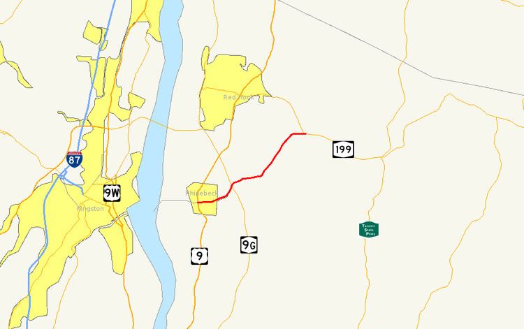 | ||
New York State Route 308 (NY 308) is a short state highway, 6.19 miles (9.96 km) in length, located entirely in northern Dutchess County, in the U.S. state of New York. It is a major collector road through mostly rural areas that serves primarily as a shortcut for traffic from the two main north–south routes in the area, U.S. Route 9 (US 9) and NY 9G, to get to NY 199 and the Taconic State Parkway. The western end of NY 308 is located within the Rhinebeck Village Historic District, a 2.6-square-mile (6.7 km2) historic district comprising 272 historical structures. The highway passes near the Dutchess County Fairgrounds, several historical landmarks, and the Landsman Kill.
Contents
- Map of NY 308 Rhinebeck NY 12572 USA
- Route description
- Native Americans and old roads
- Designation
- Major intersections
- References
Map of NY-308, Rhinebeck, NY 12572, USA
Indicated by artifacts found near Lake Sepasco, a small lake along NY 308, the highway began its history in about 1685, when a group of Native Americans called the Sepasco built the Sepasco Trail; this trail ran from the Hudson River, eastward through modern-day Rhinebeck (then Sepasco or Sepascoot), and ended at Lake Sepasco, following roughly Route 308 and its side roads. The trail remained until 1802, when part of the Ulster and Delaware Turnpike — also known as the Salisbury Turnpike — was chartered over the trail and extended from Salisbury, Connecticut to the Susquehanna River at or near the Town of Jericho (now Bainbridge).
Route 308 was designated as part of the 1930 renumbering of New York state highways, incorporating a portion of the former Ulster and Delaware Turnpike. The route originally extended from Milan westward to Rhinecliff to serve a ferry landing on the Hudson River. It was truncated to US 9 in the 1960s but its former routing to Rhinecliff is still state-maintained as an unsigned reference route. The highway was also intended to be part of the then-new Kingston–Rhinecliff Bridge until plans were changed to involve other routes and the building site for the bridge was moved about 3 miles (5 km) northward.
Route description
Part of NY 308 is located along the Rhinebeck Village Historic District, a 1,670-acre (6.8 km2) historic district that contains 272 buildings in a variety of architectural styles dating from over 200 years of the settlement's history. It was added to the National Register of Historic Places in 1979 as a well-preserved and cohesively built area of historic buildings. A notable attraction is the Beekman Arms Inn, which is located at the corner of NY 308 and US 9. Founded in 1776, it claims to be the oldest continuously-operated inn located in the United States.
Route 308 begins at US 9 in the Dutchess County village of Rhinebeck, at about 200 feet (61 m) in elevation. To the south is the American Legion Park, a small lake, and the Rhinebeck Cemetery. In the center of the village is the Rhinebeck, New York U.S. Post Office, which is situated very close to the US 9 / NY 308 intersection. The Post Office was established in 1940, and was added to the National Register of Historic Places in 1989. At this point, the Dutchess County Fairgrounds are located just to the north of Route 308. The highway proceeds eastward on East Market Street, soon exiting Rhinebeck while it runs parallel to the Landsman Kill River, a minor tributary of the Hudson River, which is sometimes known as Landsman Kill or Landsmankill. The Landsman Kill has numerous spawning runs of smelt, alewife, and blueback herring.
An intersection with County Route 101 (CR 101, known as Violet Hill Road) soon follows, as NY 308 turns slightly to the north. It intersects with NY 9G via an interchange before crossing the stream and gradually turning to the east into a relatively rural area. Between US 9 and NY 9G, NY 308 carries an average of about 6,400 vehicles per day. East of NY 9G, the traffic volume drops to about 3,700 vehicles per day. Several small lakes surround NY 308 as it intersects CR 52 in the hamlet of Eighmyville and subsequently turns to the northeast, traveling within a large open field. NY 308 then travels west of Sepasco Lake before turning on an eastward route once again. The highway runs initially in a fairly flat area, although passes between two large hills of at least 400 feet (120 m). It passes just to the south of the Red Hook Golf Club before coming to an end at NY 199 in Rock City, a hamlet within the town of Milan that is situated just east of where the Milan, Red Hook, and Rhinebeck town lines converge.
Native Americans and old roads
Indicated by artifacts recovered close to the road in Milan and in other areas along the Hudson River, the earliest inhabitants of the northern Dutchess County region were the Mohicans, a Native American nation, about 3,000 years ago. The range of the Mohicans extended from northern Dutchess County to the southern tip of Lake Champlain, and from the Catskill Mountains to the Berkshires in Massachusetts. The total population of the Mohicans was estimated at 8,000 during the time of first contact with the Europeans, although only 800 remained after the American Revolution. Artifacts were also recovered along the shore of Lake Sepasco—a small lake NY 308 passes near its ending terminus. Those artifacts recovered included ancient arrowheads, and are now on display at the Museum of Rhinebeck History.
A group of these Native Americans were, in deeds and correspondence, known as the Sepasco Indians, a name specific to Native Americans in the Sepasco area (modern-day Rhinebeck). The word Sepasco probably originated from the tribe's word for little river or stream, sepuus, which is believed to have referred to the Landsman Kill, a stream parallel to NY 308. After the American Civil War, only a few of the Sepasco were left; the last Sepasco died in a hut near Welch's Cave and Lake Sepasco and was reported in the local newspaper in 1867. By 1685, a trail known as the Sepasco Trail was formed by them and was routed from the Hudson River, eastward through the present-day Village of Rhinebeck, ending at Lake Sepasco. The trail from the Village of Rhinebeck to Lake Sepasco follows roughly modern-day Route 308, in some areas slightly to the south, where the highway's side roads are curved in a pattern similar to that of the Sepasco Trail. It is possible that the trail as a whole existed as a spur of an ancient path that stretched from Rhinebeck to Cornwall, Connecticut.
The trail remained intact until 1802, when part of the Ulster and Delaware Turnpike was chartered over it "for improving and making a road from the west line of the Town of Salisbury in the State of Connecticut to the Susquehannah [sic] River at or near the Town of Jericho [present-day Bainbridge]". The portion of the Ulster and Delaware Turnpike east of the Hudson River was also commonly known as the Ulster and Salisbury Turnpike. The turnpike crossed the river by way of the Kingston–Rhinecliff Ferry and used modern Rhinecliff Road and West Market Street to the village center of Rhinecliff, then followed roughly modern NY 308 to the hamlet of Eighmyville. It continued east from there using part of CR 52 to eventually connect with NY 199.
A bronze plaque attached to a large boulder was erected in November 1922 by Chancellor Livingston Chapter of the Daughters of the American Revolution on the property of the Beekman Arms, that marked the crossing of the Kings Highway (present-day US 9) and the Ulster and Salisbury Turnpike. Still existent, it reads "This stone marks the crossing of the Kings Highway and the Sepasco Indian Trail, later named the Ulster and Salisbury Turnpike, over which traveled the Connecticut Pioneers to their new homes in western New York."
Designation
The NY 308 designation was assigned as part of the 1930 renumbering of New York state highways. At the time, it extended from the Rhinecliff ferry landing to Rock City in the town of Milan. West of US 9, NY 308 continued to follow the old turnpike alignment to Hutton Street, where it connected to the Kingston–Rhinecliff Ferry. In 1947, the ferry was the only crossing of the Hudson River between Catskill (the Rip Van Winkle Bridge) and Poughkeepsie (the Mid-Hudson Bridge)—a distance of 36 miles (58 km)—and the only one serving the Kingston area.
Initial plans for the Kingston–Rhinecliff Bridge, a structure that replaced the ferry between the two locations, called for the bridge to span the Hudson River between downtown Kingston (at Kingston Point) and the village of Rhinebeck along a corridor similar to that of NY 308. Due to political and economic factors, the bridge site was moved 3 miles (5 km) upstream (northward). The bridge, then partially complete, opened to traffic on February 2, 1957, at which time the ferry service between Kingston and Rhinecliff was terminated. However, NY 308 continued to extend west to Rhinecliff up to the 1960s, when it was truncated to US 9 in the village of Rhinebeck. The section of former NY 308 west of US 9 is now designated as NY 982M, an unsigned reference route.
Major intersections
The entire route is in Dutchess County.