
Country United States County Dutchess Elevation 203 ft (62 m) Area 103.7 km² Local time Sunday 3:25 AM | State New York Established 1812 Time zone Eastern (EST) (UTC-5) Population 11,319 (2010) | |
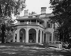 | ||
Weather 0°C, Wind NE at 11 km/h, 79% Humidity Points of interest Old Rhinebeck Aerodrome, Montgomery Place, Poets' Walk Park, Tivoli Park, Red Hook Recreation Park Inc | ||
Red Hook is a town in Dutchess County, New York, United States. The population was 11,319 at the 2010 census. The name is supposedly derived from the red foliage on trees on a small strip of land on the Hudson River. The town contains two villages, Red Hook and Tivoli. The town is in the northwest part of Dutchess County. U.S. Route 9 and State Route 9G pass through the town.
Contents
- Map of Red Hook NY USA
- History
- Geography
- Education
- Demographics
- Communities and locations in the Town of Red Hook
- Airport
- Notable people
- References
Map of Red Hook, NY, USA
The town also contains two hamlets. Bard College is in the hamlet of Annandale-on-Hudson. The Unification Theological Seminary is in the hamlet of Barrytown. Both hamlets are located within the Hudson River Historic District.
History
The region was settled in the late 17th century under the Schuyler Patent. Prior to 1812, Red Hook was part of the town of Rhinebeck. Because Rhinebeck, as well other towns, had populations over 5,000 residents, the state legislature authorized the separation of these two precincts on June 12 to accommodate and encourage public attendance at town meetings via horseback or carriage. The first documented Town of Red Hook meeting was on April 6, 1813, in a local inn and held yearly afterwards as required by law. Wealthy landowning farmers oversaw the maintenance of their assigned roads with the help of their farm workers and neighbors. The Red Hook Society for the Apprehension and Detention of Horse Thieves is thought to be one of the oldest formal organizations in the state and still holds an annual meeting.
Geography
According to the United States Census Bureau, the town has a total area of 40.0 square miles (103.7 km2), of which 36.2 square miles (93.7 km2) is land and 3.9 square miles (10.0 km2), or 9.67%, is water.
The north town line is the border of Columbia County. The west town line is the border of Ulster County and is defined by center of the Hudson River.
Education
The town of Red Hook has its own school district (which also includes part of the neighboring towns of Milan and Livingston). Over 700 students are enrolled in the high school. Enrollment in the elementary and middle schools is growing each year. Grades pre-kindergarten to five attend the Mill Road Elementary School, grades 6-8 attend the Linden Avenue Middle School, and grades 9-12 attend the Red Hook High School.
In sports, Red Hook High School is ranked Class A in soccer, basketball, softball and baseball as well as Class B in all other sports. It is located in the Section 9 district. In 2006, Red Hook's varsity volleyball team won the Mid-Hudson Athletic League, and Section IX championships. That same year, the team participated in the NYSPHSAA state championships, finishing in third place in the class B division. In 2007, the team were once again Mid-Hudson Athletic League champions and Section IX champions, this time finishing in second at the NYSPHAA state championships. In 2008, 2009, 2010, 2011, 2012, and 2013 the Red Hook Boy's Varsity Lacrosse Team won the Section IX Championship six times in a row, earning six titles in seven years, since the program's creation. However, the school is primarily known for its basketball program and has consistently won sectional titles and contended for state championships. Red Hook High School was ranked at #280 among the thousands of high schools across the country by Newsweek. Over 80% of its graduates go on to two and four year colleges.
Demographics
As of the census of 2000, there were 10,408 people, 3,574 households, and 2,473 families residing in the town. The population density was 283.6 people per square mile (109.5/km²). There were 3,840 housing units at an average density of 104.6 per square mile (40.4/km²). The racial makeup of the town was 94.20% White, 1.44% African American (U.S. Census)African American, 0.08% Native American, 2.08% Asian, 0.11% Pacific Islander, 0.65% from other races, and 1.45% from two or more races. Hispanic or Latino of any race were 2.65% of the population.
There were 3,574 households out of which 35.5% had children under the age of 18 living with them, 56.5% were married couples living together, 9.3% had a female householder with no husband present, and 30.8% were non-families. 23.4% of all households were made up of individuals and 9.1% had someone living alone who was 65 years of age or older. The average household size was 2.63 and the average family size was 3.14.
In the town, the population was spread out with 24.9% under the age of 18, 15.0% from 18 to 24, 25.8% from 25 to 44, 22.6% from 45 to 64, and 11.7% who were 65 years of age or older. The median age was 36 years. For every 100 females there were 94.5 males. For every 100 females age 18 and over, there were 89.0 males.
The median income for a household in the town was $46,701, and the median income for a family was $57,950. Males had a median income of $42,099 versus $26,694 for females. The per capita income for the town was $20,410. About 5.0% of families and 8.7% of the population were below the poverty line, including 7.8% of those under age 18 and 5.2% of those age 65 or over.
Communities and locations in the Town of Red Hook
Airport
Sky Park Airport is a public use general aviation facility located two nautical miles (4 km) east of Red Hook's central business district.