
Area 17,718 km² | Website Official website Administrative division Ajmer division | |
 | ||
Tehsils University Jain Vishva Bharati University Destinations Nagaur, Khimsar, Sambhar Salt Lake, Kuchaman City, Sujangarh Points of interest Sambhar Salt Lake, Meera Bai Mandir, Hotel Kuchaman Fort, Mahi Darwaja, Butati dham | ||
Nagaur District is one of the 33 districts of the State of Rajasthan in western India. Panchayati Raj was introduced here. Area of the district is 17,718 km2. The city of Nagaur is the district headquarters.
Contents
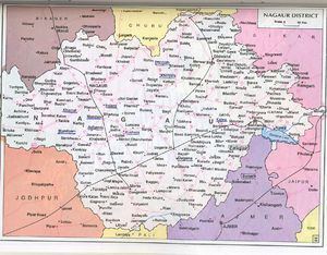
Map of Nagaur, Rajasthan
Geography
Nagaur District is situated between 26°25' & 27°40' North Latitude & 73°.10' & 75°.15' East Longitude. The district is bounded by Bikaner District to the northwest, Churu District to the north, Sikar District to the northeast, Jaipur District to the east, Ajmer District to the southeast, Pali District to the south, and Jodhpur District to the southwest and west. The district lies in the Marwar region of Rajasthan, in the Northwestern thorn scrub forests belt surrounding the Thar Desert. The Aravalli Range extends across the southeastern portion of the district, and the saline Sambhar Lake, India's largest salt lake and Rajasthan's largest lake, lies at the southwestern corner of the district, straddling the boundary with Jaipur District. Kheduli is a historic palace where pupil of khawaja moiniddin chisti hamiduddin nagouri lived for 10 years and located on the railway line of jaipur-Jodhpur.
Tehsils
The district consists 12 Main tehsils. These are Nagaur, Kheenvsar, Jayal, Merta City, Degana, Didwana, Ladnun, Parbatsar, Makrana, Kuchaman City, Nawa, Mundwa. all of these are Sub-divisions also. There are 11 blocks and 1607 villages in the district.
Demographics
According to the 2011 census Nagaur district has a population of 3,309,234, roughly equal to the nation of Uruguay or the US state of Connecticut. This gives it a ranking of 102nd in India (out of a total of 640). The district has a population density of 187 inhabitants per square kilometre (480/sq mi) . Its population growth rate over the decade 2001-2011 was 19.25%. Nagaur has a sex ratio of 948 females for every 1000 males, and a literacy rate of 64.08%. Jaat are the dominant caste in this district.