
Mountains Guru Shikhar, Dhosi Hill | Length 692 km (430 mi) Elevation 1,722 m Country India Passes Haldighati | |
 | ||
Similar Guru Shikhar, Eastern Ghats, Dhupgarh, Anamudi, Kangchenjunga | ||
The Aravalli Range (Hindi: अरावली, lit. 'line of peaks') is a range of mountains in Western India running approximately 692 km (430 mi) in a northeastern direction across the Indian states of Gujarat, Rajasthan, and Haryana, ending in Delhi.
Contents
- Map of Aravalli Range Palasama Rajasthan 313325
- Features
- Mining
- Ganeshwar sunari Cultural Complex
- Ecological concerns
- References
Map of Aravalli Range, Palasama, Rajasthan 313325
Features
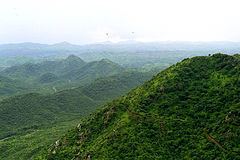
The Aravalli range are the oldest fold mountains in India. The northern end of the range continues as isolated hills and rocky ridges into Haryana state, ending in Delhi. The famous Delhi Ridge is the last leg of the Aravalli Range, which traverses through South Delhi and terminates into Central Delhi where Raisina hill is its last extension. It is one of the worlds' oldest mountain ranges. It dates back to a pre-Indian subcontinental collision with the mainland Eurasian Plate. The southern end is at Palanpur near Ahmedabad, Gujarat. The highest peak is Guru Shikhar in Mount Abu in Rajasthan. Rising to 5650 feet (1722 meters), it lies near the south-western extremity of the range, close to the border with Gujarat state. The city of Udaipur with its lakes lies on the south slope of the range in Rajasthan. Numerous rivers rise amidst the ranges including the Banas River, the Luni River, the Sahibi, the Sakhi, and the Sabarmati River.Chambal and Luni are two main rivers that flow through Rajasthan. The Aravalli Range is the eroded stub of a range of ancient folded mountains. The range rose in a Precambrian event called the Aravalli-Delhi orogen. The range joins two of the ancient segments that make up the Indian craton, the Marwar segment to the northwest of the range, and the Bundelkhand segment to the southeast. Old fold mountains are characterized by having stopped growing higher due to the cessation of upward thrust caused by the stopping of movement of the tectonic plates in the Earth's crust below them. In ancient times they were extremely high but since have worn down almost completely by millions of years of weathering. In contrast, the Himalayas are continuously rising young fold mountains of today.
Mining
Mining of copper and other metals in the Aravalli range dates back to at least 5th century BC, based on carbon dating.
Recent research indicates that copper was already mined here during Sothi-Siswal period going back to c. 4000 BCE. Ancient Kalibangan and Kunal, Haryana settlements obtained copper here.
Ganeshwar sunari Cultural Complex
Ganeshwar Sunari Cultural Complex (GSCC) is a collection of third millennium BC settlements in the area of the Aravalli Hill Range. Among them, there are similarities in material culture, and in the production of copper tools. They are located near the copper mines.
"The GSCC is east of the Harappan culture, to the north-east of Ahar-Banas Complex, north/north west to the Kayatha Culture and at a later date, west of the OCP-Copper Hoard sites (Ochre Coloured Pottery culture-Copper Hoard Culture). Located within the regions of the Aravalli Hill Range, primarily along the Kantli, Sabi, Sota, Dohan and Bondi rivers, the GJCC is the largest copper producing community in third millennium BC South Asia, with 385 sites documented. Archaeological indicators of the GSCC were documented primarily in Jaipur, Jhunjhunu, and Sikar districts of Rajasthan, India ..."
Among their pottery, we find the 'Incised ware', and 'Reserved Slip ware'.
There are two main type sites, Ganeshwar, and Sunari, in Tehsil Kot Putli, Jaipur District (geo Coordinates: N 27° 35' 51", 76° 06' 85" E).
Ecological concerns
In May 1992, some parts of the Aravalli hills in Rajasthan and Haryana were protected from mining through the Ecologically Sensitive Areas clauses of Indian laws. In 2003, The central government of India prohibited mining operations in these areas. In 2004, India's Supreme Court banned mining in the notified areas of Aravalli range. In May 2009, the Supreme Court extended the ban on mining in an area of 448 km2 across Faridabad, Gurgaon and Mewat districts in Haryana, covering Aravalli range.
A 2013 report used high resolution Cartosat-1 & LISS-IV satellite imaging to determine the existence and condition of mines in Aravalli range. In Guru Gram district, the Aravalli hills occupy an area of 11,256 hectares, of which 491 (4.36%) hectares had mines, of which 16 hectares (0.14%) were abandoned flooded mines. In Faridabad district and Mewat districts, about 3610 hectares were part of mining industry, out of a total of 49,300 hectares. These mines were primarily granite and marble mines for India's residential and real estate construction applications. In Central Rajasthan region, Sharma states that the presence of some mining has had both positive and negative effect on neighboring agriculture and ecosystem. The rains induced wash brings nutrients as well as potential contaminants.