
Length 35.5 km Catchment area 5,700 km² | Max. length 35.5 km (22.1 mi) Surface elevation 360 m Mean depth 60 cm | |
 | ||
Max. width 3 to 11 km (1.9 to 6.8 mi) Surface area 190 to 230 km (73 to 89 sq mi) Similar Sambhar Lake Town railway st, Phulera Junction railway st, Wular Lake, Chilika Lake, Pushkar Lake | ||
Walking on the surface of the sea sambhar salt lake rajasthan
The Sambhar Salt Lake, India's largest inland salt lake, a bowl shape lake encircles historical Sambhar Lake Town located 96 km south west of the city of Jaipur (Northwest India) and 64 km north east of Ajmer along National Highway 8 in Rajasthan.
Contents
- Walking on the surface of the sea sambhar salt lake rajasthan
- Map of Shakambari Jheel Rajasthan 341509
- GeographyEdit
- Economic importanceEdit
- Ecological importanceEdit
- MythologyEdit
- References
Map of Shakambari Jheel, Rajasthan 341509
GeographyEdit
The lake receives water from an endorheic basin with 5700 square km catchment area. It is not part of the Ganga river basin area and is geographically a separate land locked river basin. The lake is actually an extensive saline wetland, with water depths fluctuating from as few as 60 centimetres (24 in) during the dry season to about 3 meters (10 ft) after the monsoon season. It occupies an area of 190 to 230 square kilometers, based on the season. It is an elliptically shaped lake 35.5 km long with a breadth varying between 3 km and 11 km. It is located in Nagaur and Jaipur districts and it also borders the Ajmer district. The circumference of the lake is 96 km, surrounded on all sides by the Aravali hills.
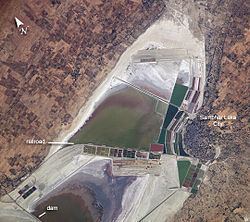
The Sambhar lake basin is divided by a 5.1 km long dam made of sandstone. After salt water reaches a certain concentration, it will be released from the west side to the eastern side by lifting dam gates. To the east of the dam are salt evaporation ponds where salt has been farmed for a thousand years. This eastern area is 80 km². and comprises salt reservoirs, canals and salt pans separated by narrow ridges. To the east of the dam is a railroad, built by the British (before India’s independence) to provide access from Sambhar Lake City to the salt works.
The nearest airport is Sanganer and the nearest railway station is Sambhar. The water is fed to the lake from streams from the rivers Mendha, Runpangarh, Khandel and Karian. The Mendha and Rupangarh are main streams. The Mendha flows from south to north and the Rupangarh flows from north to south.
Temperatures reach 40° Celsius in summer and stay at around 11° Celsius in winter.
Economic importanceEdit
It is India's largest saline lake and is the source of most of Rajasthan's salt production. It produces 196,000 tonnes of clean salt every year, which equates to around 9% of India's salt production. Salt is produced by evaporation process of brine and is mostly managed by Shambar Salts Ltd.(SSL), a joint venture of the Hindustan Salts Ltd. and the state government. SSL owns 3% of the eastern lake.
There are 38 clusters of villages surrounding the lake. Major settlements include Sambhar, Gudha, Jabdinagar, Nawa, Jhak, Korsina, Jhapok, Kanseda, Kuni, Tyoda, Govindi, Nandha, Sinodiya, Arwik ki dhani, Khanadja, Khakharki, Kerwa ki dhani, Rajas, Jalwali ki dhani.
Ecological importanceEdit
Sambhar has been designated as a Ramsar site (recognized wetland of international importance) because the wetland is a key wintering area for tens of thousands of flamingos and other birds that migrate from northern Asia. The specialized algae and bacteria growing in the lake provide striking water colours and support the lake ecology that, in turn, sustains the migrating waterfowl. There is other wildlife in the nearby forests, where Nilgai move freely along with deer and foxes.
The salt (NaCl) concentration in this lake water differs with season. The salt concentration in the pans Kyars varies and accordingly the color ranges from green, orange, pink, purple pink, red due to the bloom of haloalkaliphilic microorganisms. The first haloalakiliphilic archaeon isolated from this lake was Natrilaba SSL1 (earlier designated as Natronobacterium SSL1 ATCC 43988 by Upasani and Desai (1990). More recently, haloalkaliphilic microalgae namely Dunaliella, Euhalothece, Nitzchia, etc. have also been isolated (Bhatt H. H.and Upasani V. N., 2016). The archaeal isolates can be source of haloalakiphilic enzymes for biotechnological applications.
MythologyEdit
The Indian epic Mahabharata mentions the Sambhar lake as part of the kingdom of the demon king Brishparva, as the place where his priest Sukracharya lived, and as the place where the marriage between his daughter, Devayani, and King Yayati took place. A temple dedicated to Devayani can be seen near the lake.
According to a local tradition, Shakambhari Devi, the tutelary goddess of Chauhan Rajputs and the consort of Lord Shiva, in return for some service done to her, converted a dense forest into a plain of silver. Subsequently, at the request of the inhabitants who dreaded the greed and strife which such a possession would excite, she transformed it into the lake. The name of the lake stems from a corruption of her name, which happened around the sixth century. The lake shore still has a temple dedicated to Shakambhari Devi.
In 1884, ancient sculpture art was discovered in the area as part of small-scale excavation work done in Sambhar lake. During that excavation, some terracotta structures, coins and seals were found along with a clay stupa. Sambhar sculpture art appears to be influenced by Buddhism. Later on, around 1934, a large scale systematic and scientific excavation was conducted in which a large number of terracotta figurines, stoneware, and decorated discs were found. A number of these sculptures from Sambhar are present at the Albert Hall Museum.