
- location below Mount Lonarch Basin area 12,352 km² | - elevation 307 m (1,007 ft) - elevation 74 m (243 ft) Country Australia | |
 | ||
- left Glenlogie Creek, Number Two Creek, Mountain Creek (Victoria), Cherry Tree Creek, Smoky Creek, Tarpaulin Creek, Campbell Creek (Victoria) - right Sandy Creek (Victoria), Brown Hill Creek (Victoria), Fentons Creek (Victoria), Sandy Creek (Victoria), Yeungroon Creek, Mosquito Creek (Victoria) Sources Pyrenees, Great Dividing Range | ||
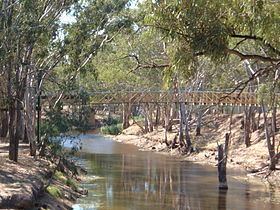
The Avoca River, an inland intermittent river of the north–central catchment, part of the Murray-Darling basin, is located in the lower Riverina bioregion and Central Highlands and Wimmera regions of the Australian state of Victoria. The headwaters of the Avoca River rise on the northern slopes of the Pyrenees Range and descend to flow into the ephemeral Kerang Lakes.
Contents
Map of Avoca River, Amphitheatre VIC, Australia
Features and locationEdit
The Avoca River drains a substantial part of central Victoria. The river rises at the foot of Mount Lonarch near the small town of Amphitheatre, and flows north for 270 kilometres (170 mi) joined by thirteen minor tributaries and through the towns of Avoca, Charlton and Quambatook. Although the Avoca River basin is part of the Murray-Darling basin, the Avoca River does not empty into the Murray. Nowhere a large stream, it dwindles as it flows north, eventually terminating in the Kerang Lakes, a network of ephemeral swamps west of Kerang and about 20 kilometres (12 mi) south of the Murray River.
Although the Avoca River has a substantial 12,000-square-kilometre (4,600 sq mi) catchment area, the fifth largest in Victoria, most of that area is on the northern plains where rainfall averages only about 350 millimetres (14 in) per year, and where there is little runoff as the terrain is very flat. The mean annual runnoff of 137 gigalitres (30×10^9 imp gal; 36×10^9 US gal) per annum accounts for only 0.67% of Victoria's runoff. Most of the water flowing in the Avoca River originates in the narrow upper portion of the catchment area, where rainfall averages about 600 millimetres (24 in) per year, most of it falling in the winter and spring.
Of all the Victorian rivers in the Murray-Darling basin, the Avoca River is the most variable. The average annual flow is 85 gigalitres (19×10^9 imp gal; 22×10^9 US gal), however recorded actual flows have varied from almost five times the average figure in very wet years to 0.5% of the average in drought years. It has an extremely variable flow, ranging from long periods of low flow that are less than 50 megalitres (11×10^6 imp gal; 13×10^6 US gal) per day to floods. In dry years, flow stops for many months.
Although it is the only river of significance in the area, the Avoca River has had no major water storages constructed on it, merely six weirs of only local significance. Little use of the river is made for irrigation as during the peak demand periods of summer and autumn, the river is often not flowing. During low flow periods the Avoca River water is usually too saline to water crops with, but can still provide drinking water for sheep and cattle.
The river is crossed by the Pyrenees Highway at Avoca; and the Borung Highway and the Calder Highway at Charlton.
EtymologyEdit
As the river is relatively long, indigenous peoples from various cultural groups lived near the river course. In the indigenous Djadjawurrung, Wathawurrung, Wergaia, and Wembawemba languages, the river has several names including Natte yaluk and Boca both with no clearly defined meaning; Bangyeno Banip meaning bunyip waterholes; Djub-djub-galg meaning a place where melaleuca was abundant; Witchelliba with witji meaning basket grass and bar meaning river; and Yangeba with no clearly defined meaning.