
Last eruption Unknown | Elevation 2,530 m | |
 | ||
Parent range Northern Yatsugatake Volcanic Group Similar Mt Yokodake, Mount Kirigamine, Mount Aka, Kurumayama, Utsukushigahara | ||
mount tateshina
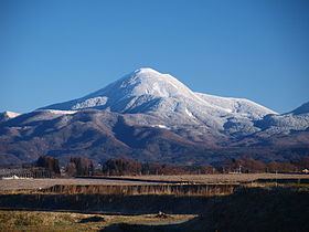
Mount Tateshina (蓼科山, Tateshina-yama) also Suwa Fuji is a complex volcano located on the border of the municipalities of Chino and Tateshina in Nagano Prefecture, Japan.
Contents
- mount tateshina
- Map of Mount Tateshina Tateshina Kitasaku District Nagano Prefecture Japan
- Japan mount tateshina rotenburo
- Outline
- Route
- References
Map of Mount Tateshina, Tateshina, Kitasaku District, Nagano Prefecture, Japan
It has an elevation of 2,530 m (8,301 ft). This mountain is one of the 100 Famous Japanese Mountains.
Japan mount tateshina rotenburo
Outline
Mount Tateshina is a typical complex volcano. About the origin of the name of this mountain, tate means water-pepper, and shina means steps or high places. So Tateshina is literally a high mountain of water-peppers. The other name of this mountain Suwa Fuji, literally, Mount Fuji of the Suwa region.
Mount Tateshina is an important part of Yatsugatake-Chūshin Kōgen Quasi-National Park.
Route
Routes to climb up Mount Tateshina are well-developed. The most popular route is to start from the Nanagome parking lot.