
Elevation 1,249 m | Prominence 836 m Parent range Hamersley Range | |
 | ||
Similar Mount Woodroffe, Mount Bruce, Mount Zeil, Mount Ossa, Bimberi Peak | ||
Mount meharry ktm 450 dirt bike run
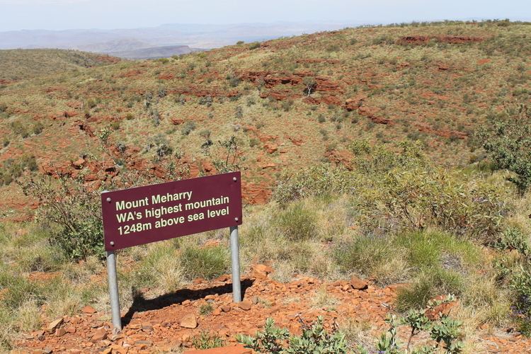
Mount Meharry is the highest mountain in Western Australia. It is located in the Hamersley Range within the southeastern part of Karijini National Park in the Pilbara region, approximately 86 kilometres (53 mi) from Wittenoom, and 87 kilometres (54 mi) from Tom Price.
Contents
- Mount meharry ktm 450 dirt bike run
- Map of Mount Meharry Karijini WA 6751 Australia
- Aussie camping adventures nissan patrol toyota landcruiser tackle mount meharry
- References
Map of Mount Meharry, Karijini WA 6751, Australia
The Pandjima peoples are the traditional owners of the area. The indigenous name for Mount Meharry is Wirlbiwirlbi.
Mount Meharry is named after William Thomas ("Tom") Meharry (1912-1967), Chief Geodetic Surveyor for Western Australia from 1959 to 1967. It was discovered (so far as non-indigenous records show) by Surveyor Trevor Markey and his party in 1967. Tom Meharry directed the survey party and performed the calculations that confirmed the mountain was the highest peak in Western Australia, being 15 m (49 ft) higher than Mount Bruce which lies 62 km northwest of Mount Meharry.
After Meharry's sudden death on 16 May 1967 the Nomenclature Advisory Committee (now the Geographic Names Committee) recommended to the Minister for Lands that the recently discovered peak be named after him. The Minister for Lands Stewart Bovell approved this on 28 July 1967 and a notice naming the peak was published in the Western Australian Government Gazette on 15 September 1967.
In 1999, Gina Rinehart, daughter of Lang Hancock applied to the Geographic Names Committee to rename the mountain after her father. The application was declined and in 2002 she lobbied the then-Premier Geoff Gallop with the same proposal. He too declined the request.
The summit of Mt Meharry can be reached from the Great Northern Highway via an unsealed road 16 km (9.9 mi) in length and a vehicular track 21 kilometres (13 mi) in length. Permission should be sought from the managers of the land over which the road and track pass. These are Juna Downs Station and the Department of Parks and Wildlife, which manages Karijini National Park. In dry conditions, a two-wheel-drive vehicle can reach the national park boundary at about 800 metres altitude, requiring a walk of about 7 kilometres to the summit.