
Country Australia | ||
 | ||
Mountains | ||
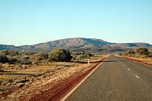
The Hamersley Range is a mountainous region of the Pilbara, Western Australia. The range runs from the Fortescue River in the northeast, 460 km south. The range contains Western Australia's highest point, Mount Meharry, which reaches approximately 1,249 metres (4,098 ft) AHD. There are many extensively-eroded gorges, such as Wittenoom Gorge. The twenty highest peaks in Western Australia are in the Hamersley Range. Geologically, they are some of the most ancient regions of the earth's crust known as the Pilbara craton.
Map of Hamersley Range, WA 6716, Australia
Some of the Peaks found in the range include Mount Bruce (1,234 metres (4,049 ft)), Mount Nameless (1,115 metres (3,658 ft)), Mount Reeder Nichols (1,109 metres (3,638 ft)), Mount Samson (1,107 metres (3,632 ft)), Mount Truchanas (1,148 metres (3,766 ft)) and Mount Tom Price (775 metres (2,543 ft)).
Karijini National Park (formerly Hamersley National Park), one of Australia's largest National Parks, is centred in the range.
The range contains large deposits of iron ore, the source of a large proportion of Australia's iron ore. It is predominately in the Banded Iron Formation (BIF) - also known as the Brockman iron formation.
Western Australia's major iron producers have mines, communities and railways that occur along the range Rio Tinto operates several iron ore mines within the range including Mt. Tom Price, Marandoo, Brockman, Channar, West Angelas, Mesa A mine, and Paraburdoo. Over 100 million tonnes of iron ore is removed from the range every year.
In 1999 a small range within the Hamersley was named the Hancock Range after the Hancock family who were pioneers in the area. The Hancock range is east of Karijini National Park in a region of broad valleys and peaks that rise to almost 1,200 metres (3,937 ft). The Hancock Range is close to Mulga Downs Station, a property owned by the Hancock family and where Lang Hancock is buried.
The traditional owners of the area that the range runs through are the Yindjibarndi peoples.