
Website Karijini National Park Phone +61 8 9189 8121 | Visitation 166,000 (in 2009) Area 6,274 km² Established 1969 | |
 | ||
Managing authorities Address Banjima Drive, Karijini WA 6751, Australia | ||
Karijini national park the pilbara western australia
Karijini National Park is a national park centred in the Hamersley Ranges of the Pilbara region in the northwestern section of the Australian state of Western Australia. The park is located just north of the Tropic of Capricorn, approximately 1,055 kilometres (656 mi) from the state's capital city, Perth. Formerly known as Hamersley Range National Park, the park was officially renamed in 1991.
Contents
- Karijini national park the pilbara western australia
- Fly through the gorges of karijini national park australia
- History
- Climate
- Geology
- Features
- Fauna
- References
At 627,422 hectares (1,550,390 acres), Karijini is the second largest national park in Western Australia with Karlamilyi National Park being the largest park.
The park is physically split into a northern and a southern half by a corridor containing the Hamersley & Robe River railway and the Marandoo iron ore mine.
The park is served by the Solomon Airport, located 15 kilometres (9.3 mi) westwards.
Fly through the gorges of karijini national park australia
History
A party led by explorer F.T. Gregory explored the area in 1861. He named the Hamersley Range, on which the park is centred, after his friend Edward Hamersley.
Climate
The park is located in the Pilbara region, and is mostly tropical semi-arid climate. In summer, thunderstorms and cyclones are common, bringing 250–350 mm of rain annually. Temperatures on summer days frequently exceed 40 degrees Celsius, while winter nights can bring frost.
Geology
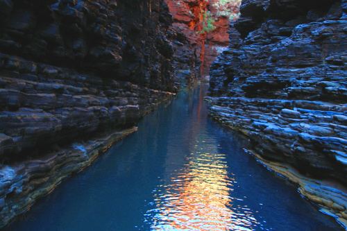
Several gorges that flow north out of the park—including Dales, Kalamina, Wittenoom and Yampire Gorges—provide spectacular displays of the rock layers:
Features
The park is most notable for its many gorges containing slot canyons, waterfalls and water holes with visitors sometimes swimming in the cold pools of water.
Hamersley Gorge is located in the northwestern region of the park, while Range Gorge is in the north, Munjina Gorge is in the east, and Hancock, Joffre, Knox, Red and Weano Gorges converge in the park's center.
While the park is fully open to the public, visitors are warned to exercise due caution when walking in and around the vicinity of Yampire and Wittenoom Gorges near the northern boundary of the park due to the presence of blue asbestos—a known cancer-causing agent when inhaled—which occurs in a number of the rock formations.
Fauna
The park's wildlife includes red kangaroos, euros, wallaroos, echidnas, geckos, goannas, bats, legless lizards and a large variety of birds and snakes, including pythons.