
Topo map USGS Mount Mansfield Elevation 1,339 m | Designated 1980 Prominence 1,107 m Easiest route Hiking | |
 | ||
Listing U.S. state high point 26thNew England Fifty Finest 3rdNew England 4000-footers Similar Camel's Hump, Mount Abraham, Mount Marcy, Killington Peak, Mount Ellen | ||
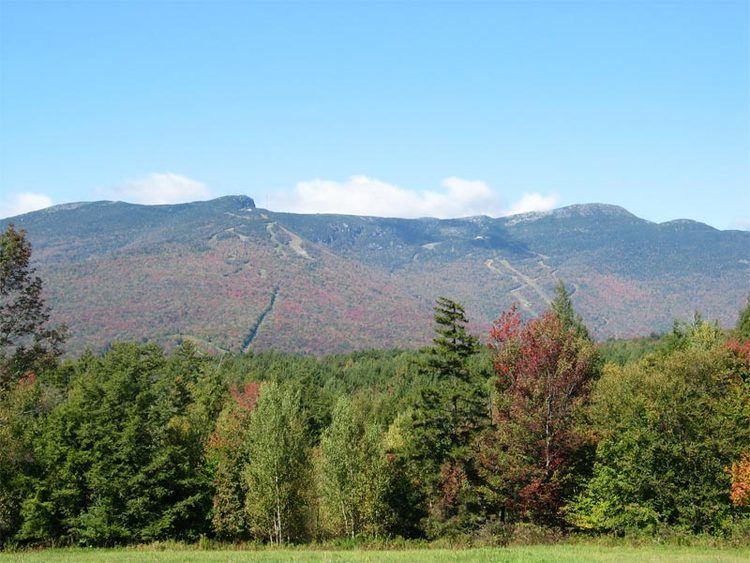
Underhill pasture and mount mansfield
Mount Mansfield is the highest mountain in Vermont with a summit that peaks at 4,393 feet (1,339 m) above sea level. The summit located within the town of Underhill in Chittenden County; the ridgeline, including some secondary peaks, extends into the town of Stowe in Lamoille County, and the mountain's flanks also reach into the town of Cambridge.
Contents
- Underhill pasture and mount mansfield
- Map of Mount Mansfield Underhill VT 05489 USA
- Geology and soilsEdit
- EtymologyEdit
- TopographyEdit
- SkiingEdit
- References
Map of Mount Mansfield, Underhill, VT 05489, USA
When viewed from the east or west, this mountain has the appearance of a (quite elongated) human profile, with distinct forehead, nose, lips, chin, and Adam's apple. These features are most distinct when viewed from the east; unlike most human faces, the chin is the highest point.
Mount Mansfield is one of three spots in Vermont where true alpine tundra survives from the Ice Ages. A few acres exist on Camel's Hump and Mount Abraham nearby and to the south, but Mount Mansfield's summit still holds about 200 acres (81 ha).
Located in Mount Mansfield State Forest, the mountain is used for various recreational and commercial purposes. "The Nose" is home to transmitter towers for a number of regional radio and TV stations. There are many hiking trails, including the Long Trail, which traverses the main ridgeline. In addition, the east flank of the mountain is used by the Stowe Mountain Resort for winter skiing. A popular tourist activity is to take the toll road (about 4 miles (6.4 km), steep, mostly unpaved, with several hairpin turns) from the Stowe Base Lodge to "The Nose" and hike along the ridge to "The Chin."
Geology and soilsEdit
The dominant bedrock of Mt. Mansfield is a mica-albite-quartz schist common to the Green Mountains. Layers of quartzite are found locally. The soils, mostly podzol, are stony with fine-earth fractions grading through textures of fine sandy loam, loam and silt loam; they are mapped mostly as Londonderry, Lyman, Peru and Tunbridge series with considerable areas of Rock Outcrop around the summit.
EtymologyEdit
The name comes from the dissolved town of Mansfield, Vermont, in which the mountain was located. It was common for settlers to name Vermont towns for their previous homes; several of the original grantees were from Mansfield, Connecticut, which in turn is known to have been named for Moses Mansfield, one of the chief landowners there. The Town of Mansfield was platted before anyone involved had visited the site; when it was surveyed, it was discovered to be mostly mountainside. Although a few hardy pioneers settled in the town's few lowlands, the town was dissolved by degrees, with the portion generally west of the mountain being annexed to Underhill in 1839, the eastern portion to Stowe in 1848 after a vote of the citizenry. The dividing line did not run exactly along the ridge of the mountain; thus, the Chin is in Underhill and the Nose in Stowe.
TopographyEdit
The ridge which forms the "head" of the "man" is aligned generally north and south. The "Adam's apple" is on the north end of the ridge, and the "forehead" to the south. From north of the mountain, looking south, this ridge appears as a triangular peak. At the northeastern portion of the mountain, there are cliffs. At the base of these cliffs (on the western side of the Notch Road, Vermont Route 108), there is a honeycomb network of talus caves. There are cliffs on the eastern side of the Notch Road as well. These two sets of facing cliffs are separated by 3 yards (2.7 m) at their base.
SkiingEdit
Along with other expert trails, a group of trails, known as the "Front Four", are Goat, Starr, National and Liftline. They have steep pitches, many natural hazards (rocks and trees), and little grooming. There are also cross country ski trails around the base of the mountain and on its lower slopes. The Bruce Trail descends the east side of the mountain while the Teardrop Trail descends west side. In addition to Stowe Mountain resort, Skiing is also available at the nearby Smugglers' Notch Resort.