
Elevation 615 m Local time Monday 2:13 PM | Postal code 3441 Federal division Division of Bendigo | |
 | ||
Prominence 643 metres (2,110 ft) AHD Parent peak Camel's Hump or Camels Hump Weather 26°C, Wind N at 10 km/h, 59% Humidity Points of interest Macedon Regional Park, Macedon Forest Glade Ga, Gardens of Tieve Tara, Camel's Hump, Stanley Park | ||
Mount macedon victoria australia jan 2015
Mount Macedon /maʊnt ˈmæsədən/ (Aboriginal Woiwurrung language: Geboor or Geburrh) is a mountain that is part of the Macedon Ranges of the Great Dividing Range, located in the Central Highlands region of Victoria, Australia. The mountain has an elevation of 1,001 metres (3,284 ft) with a prominence of 643 metres (2,110 ft) and is located approximately 65 kilometres (40 mi) northwest of Melbourne.
Contents
- Mount macedon victoria australia jan 2015
- Map of Mount Macedon VIC 3441 Australia
- Etymology
- Summit
- Climate
- Notable events
- References
Map of Mount Macedon VIC 3441, Australia
Etymology
The mountain is known as Geboor or Geburrh in the Aboriginal Woiwurrung language of the Wurundjeri people.
The mountain was originally sighted by Hamilton Hume and William Hovell on their 1824 expedition to Port Phillip from New South Wales. They named it Mount Wentworth. It was renamed Mount Macedon by explorer Major Thomas Mitchell who ascended the mountain in 1836. He named it after Philip of Macedon in honour of the fact that he was able to view Port Philip from the summit. Several other geographic features along the path of his third Australia Felix expedition were named after figures of Ancient Macedonia including the nearby Campaspe River and Mount Alexander near Castlemaine (named after Alexander the Great).
Summit
The highest peak of Mount Macedon is Camel's Hump, or Camels Hump, one of three mamelons in the area, the rocky outcrop of a once small steep-sided volcano, with an elevation estimated at 1,011 metres (3,317 ft), and at times is covered in snow. Camel's Hump, together with Hanging Rock and Croziers Rocks are igneous trachyte rocks of the crag and are favoured by rock climbers. The mountain has become a popular venue for sport climbing and for families, due to its proximity to Melbourne.
The view from the summit of Mount Macedon is spectacular, and takes in Melbourne city, the Dandenong Ranges and the You Yangs near Geelong.
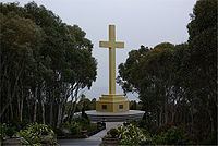
Mount Macedon Memorial Cross is a 21 metres (69 ft) high monument standing near the summit of the mountain, in an area called Cross Reserve. It was established in 1935 by William Cameron, an early resident of the town of Mount Macedon, as a memorial to his son and others who had died in World War I.
Climate
Total rainfall approaches 1,000 millimetres (39 in) annually, reaching a maximum in winter, with minimum amounts occurring during the summer months of January to March. Snowfalls occurs on 15–20 days a year, with snow lying occurring on 10–15 days a year. As with the entire region, Mount Macedon is susceptible to severe frost, generally between the months of May and September, with light frosts throughout the rest of the year and minimal frost between January and March. Extreme minimums have been near −9 °C (16 °F). A feature of the region in winter is the occasional appearance of black ice.
Notable events
On 8 November 1948, Douglas DC-3 VH-UZK operated by Australian National Airways crashed on Mount Macedon. The pilot and first officer died; the cabin crew and passengers all survived, with relatively minor injuries. The event is commemorated on a plaque in Cross Reserve.