
Prominence 151 m Listing Four-thousand footers | Elevation 1,450 m Easiest route Hiking Parent range Appalachian Mountains | |
 | ||
Similar North Brother, Mount Redington, South Crocker Mountain, Saddleback Horn, Spaulding Mountain | ||
Hamlin peak me ne 4 000 footer 66
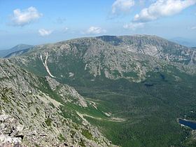
Hamlin Peak is a 4,756-foot (1,450 m) mountain located in Baxter State Park in Piscataquis County, Maine. Hamlin Peak is a northern spur of the greater Mount Katahdin massif and is flanked to the south by Baxter Peak, and to the north by the Howe Peaks. Since it rises nearly 500 feet (150 m) above the col joining it to the higher Baxter Peak, Hamlin Peak qualifies as a four-thousand footer based on the topographic prominence criterion used by the Appalachian Mountain Club, and is ranked as the second-highest peak in Maine.
Contents
- Hamlin peak me ne 4 000 footer 66
- Map of Hamlin Peak Northeast Piscataquis ME 04462 USA
- Katahdin and hamlin peak maine july 2013
- References
Map of Hamlin Peak, Northeast Piscataquis, ME 04462, USA
The southeast face of Hamlin Peak drains into the Great Basin, where water ultimately flows into the Penobscot River and eventually empties into the Atlantic Ocean at Penobscot Bay.
There are several trails that lead to or near the summit of Hamlin Peak.