
Named for Daniel Morgan Area 1,590 km² Population 20,265 (2013) | Founded 1833 Unemployment rate 7.1% (Apr 2015) | |
 | ||
Rivers Big Buffalo Creek, Straight Fork, Brush Creek, Smith Creek Points of interest Lake of the Ozarks, Jacobs Cavern, Morgan County Historical, Buffalo Creek Winery | ||
140 acres for sale in morgan county missouri
Morgan County is a county located in the central portion of the U.S. state of Missouri. As of the 2010 census, the population was 20,565. Its county seat is Versailles. The county was organized January 5, 1833 and named for General Daniel Morgan of the American Revolutionary War.
Contents
- 140 acres for sale in morgan county missouri
- Map of Morgan County MO USA
- 320 acres for sale in morgan county missouri
- History
- Geography
- Adjacent counties
- Major highways
- Demographics
- Public schools
- Private schools
- Local
- State
- Federal
- Missouri Presidential Preference Primary 2008
- References
Map of Morgan County, MO, USA
320 acres for sale in morgan county missouri
History
Morgan County was organized in 1833 upon separation from Cooper County. It is named in honor of Revolutionary War General Daniel Morgan. Some parts of Morgan County touch the Lake of the Ozarks.
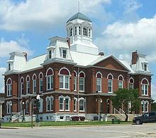
Its varied history includes the Mulhollen Station, through which mail traveled with the Butterfield Stage Line in 1858. Established in 1853, the Martin Hotel was visited by P. T. Barnum and Jesse James. Listed on the National Register of Historic Places in 1978, the Martin Hotel operates as a museum. The Morgan County Courthouse, established in Versailles, burned in 1887; however, the majority of the records were rescued, and the courthouse was soon rebuilt.
Coal mining was historically an important economic activity in Morgan County.
Geography
According to the U.S. Census Bureau, the county has a total area of 614 square miles (1,590 km2), of which 598 square miles (1,550 km2) is land and 16 square miles (41 km2) (2.7%) is water.
Adjacent counties
Major highways
Demographics
As of the census of 2007, there were 20,820 people, over 7,850 households, and over 5,549 families residing in the county. The population density was 32 people per square mile (12/km²). There were 13,898 housing units at an average density of 23 per square mile (9/km²). The racial makeup of the county was 97.34% White, 0.51% Black or African American, 0.63% Native American, 0.12% Asian, 0.02% Pacific Islander, 0.16% from other races, and 1.22% from two or more races. Approximately 0.83% of the population were Hispanic or Latino of any race.
There were 7,850 households out of which 26.60% had children under the age of 18 living with them, 60.50% were married couples living together, 7.10% had a female householder with no husband present, and 29.30% were non-families. 25.10% of all households were made up of individuals and 11.90% had someone living alone who was 65 years of age or older. The average household size was 2.42 and the average family size was 2.88.
In the county, the population was spread out with 23.80% under the age of 18, 6.20% from 18 to 24, 23.10% from 25 to 44, 27.30% from 45 to 64, and 19.60% who were 65 years of age or older. The median age was 43 years. For every 100 females there were 97.20 males. For every 100 females age 18 and over, there were 95.00 males.
The median income for a household in the county was $30,659, and the median income for a family was $35,908. Males had a median income of $26,579 versus $19,072 for females. The per capita income for the county was $15,950. About 12.10% of families and 16.20% of the population were below the poverty line, including 25.60% of those under age 18 and 9.70% of those age 65 or over.
Public schools
Private schools
Local
The Republican Party controls politics at the local level in Morgan County. Republicans hold all but five of the elected positions in the county.
State
Morgan County is divided into four legislative districts in the Missouri House of Representatives, all of which are held by Republicans.
All of Morgan County is a part of Missouri’s 6th District in the Missouri Senate and is currently represented by Mike Kehoe (R-Jefferson City).
Federal
All of Morgan County is included in Missouri’s 4th Congressional District and is currently represented by Vicky Hartzler (R-Harrisonville) in the U.S. House of Representatives.