
Area 1,554 km² Population 25,092 (2013) | Founded 1837 Unemployment rate 6.1% (Apr 2015) | |
 | ||
Website www.millercountymissouri.org Cities Rivers Osage River, South Moreau Creek, Sugar Creek | ||
70 acres miller county missouri
Miller County is a county located in the U.S. state of Missouri. As of the 2010 census, the population was 24,748. Its county seat is Tuscumbia. The county was organized February 6, 1837 and named for John Miller, former U.S. Representative and Governor of Missouri.
Contents
- 70 acres miller county missouri
- Map of Miller County MO USA
- 200 acres miller county missouri
- Geography
- Adjacent counties
- Major highways
- Demographics
- Public schools
- Private schools
- Local
- State
- Federal
- Missouri Presidential Preference Primary 2008
- References
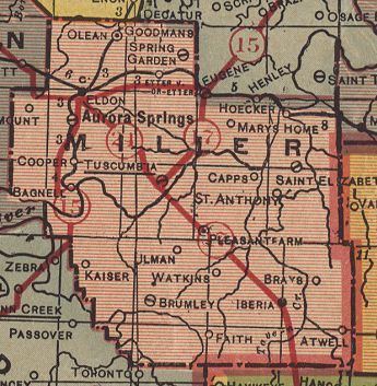
Map of Miller County, MO, USA
200 acres miller county missouri
Geography
According to the U.S. Census Bureau, the county has a total area of 600 square miles (1,600 km2), of which 593 square miles (1,540 km2) is land and 7.4 square miles (19 km2) (1.2%) is water.
Adjacent counties
Major highways
Demographics
As of the census of 2000, there were 23,564 people, 9,284 households, and 6,443 families residing in the county. The population density was 40 people per square mile (15/km²). There were 11,263 housing units at an average density of 19 per square mile (7/km²). The racial makeup of the county was 97.99% White, 0.28% Black or African American, 0.46% Native American, 0.13% Asian, 0.02% Pacific Islander, 0.29% from other races, and 0.84% from two or more races. Approximately 0.98% of the population were Hispanic or Latino of any race.
There were 9,284 households out of which 32.60% had children under the age of 18 living with them, 56.00% were married couples living together, 9.20% had a female householder with no husband present, and 30.60% were non-families. 26.10% of all households were made up of individuals and 11.90% had someone living alone who was 65 years of age or older. The average household size was 2.50 and the average family size was 3.00.
In the county, the population was spread out with 26.30% under the age of 18, 8.40% from 18 to 24, 27.40% from 25 to 44, 22.70% from 45 to 64, and 15.30% who were 65 years of age or older. The median age was 37 years. For every 100 females there were 97.30 males. For every 100 females age 18 and over, there were 93.70 males.
The median income for a household in the county was $30,977, and the median income for a family was $36,770. Males had a median income of $26,225 versus $18,903 for females. The per capita income for the county was $15,144. About 10.80% of families and 14.20% of the population were below the poverty line, including 19.30% of those under age 18 and 14.70% of those age 65 or over.
Public schools
Private schools
Local
The Republican Party completely controls politics at the local level in Miller County. Republicans hold all of the elected positions in the county.
State
Miller County is divided into two legislative districts in the Missouri House of Representatives, both of which are held by Republicans.
All of Miller County is a part of Missouri’s 6th District in the Missouri Senate and is currently represented by Mike Kehoe (R-Jefferson City).
Federal
All of Miller County is included in Missouri’s 9th Congressional District and is currently represented by Blaine Luetkemeyer (R-St. Elizabeth). It is the home county to the congressman.