
Website www.coopercountymo.gov Founded 1818 Unemployment rate 6.4% (Apr 2015) | Area 1,474 km² Population 17,647 (2013) University Kemper Military School | |
 | ||
Named for Sarshell Cooper, frontier settler who was killed by Native Americans near Arrow Rock in 1814 | ||
Cooper County is a county located in the central portion of the U.S. state of Missouri. As of the 2010 census, the population was 17,601. Its county seat is Boonville. The county was organized December 17, 1818 and named for Sarshell Cooper, a frontier settler who was killed by Native Americans near Arrow Rock in 1814.
Contents
- Map of Cooper County MO USA
- Geography
- Adjacent counties
- National protected area
- Demographics
- Public schools
- Private schools
- Local
- State
- Federal
- Missouri Presidential Preference Primary 2008
- Cities
- Villages
- Unincorporated communities
- Townships
- Notable natives
- References
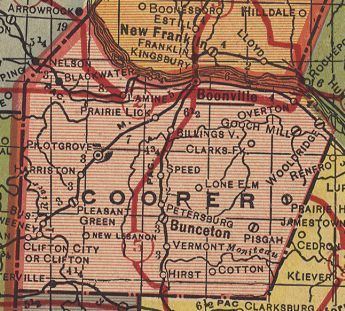
Map of Cooper County, MO, USA
Geography
According to the U.S. Census Bureau, the county has a total area of 569 square miles (1,470 km2), of which 565 square miles (1,460 km2) is land and 4.4 square miles (11 km2) (0.8%) is water.
Adjacent counties
National protected area
Demographics
As of the 2000 census, there were 16,670 people, 5,932 households and 4,140 families residing in the county. The population density was 30 per square mile (11/km²). There were 6,676 housing units at an average density of 12 per square mile (5/km²). The racial makeup of the county was 89.05% White, 8.96% Black or African American, 0.36% Native American, 0.23% Asian, 0.02% Pacific Islander, 0.28% from other races, and 1.11% from two or more races. Approximately 0.86% of the population were Hispanic or Latino of any race. 38.1% were of German, 18.7% American, 8.1% English and 8.0% Irish ancestry.
There were 5,932 households, of which 31.80% had children under the age of 18 living with them, 57.40% were married couples living together, 9.00% had a female householder with no husband present, and 30.20% were non-families. 26.10% of all households were made up of individuals and 12.60% had someone living alone who was 65 years of age or older. The average household size was 2.46 and the average family size was 2.97.
Age distribution was 22.80% under the age of 18, 14.00% from 18 to 24, 27.40% from 25 to 44, 20.60% from 45 to 64, and 15.20% who were 65 years of age or older. The median age was 35 years. For every 100 females there were 117.40 males. For every 100 females age 18 and over, there were 120.00 males.
The median household income was $35,313, and the median family income was $41,526. Males had a median income of $28,513 versus $20,965 for females. The per capita income for the county was $15,648. About 8.30% of families and 10.70% of the population were below the poverty line, including 12.80% of those under age 18 and 8.30% of those age 65 or over.
Public schools
Private schools
Local
The Republican Party predominantly controls politics at the local level in Cooper County. Republicans hold all but one of the elected positions in the county.
State
Cooper County is divided into three legislative districts in the Missouri House of Representatives, all of which are represented by Republicans.
All of Cooper County is a part of Missouri’s 19th District in the Missouri Senate and is currently represented by Kurt Schaefer (R-Columbia).
Federal
All of Cooper County is included in Missouri’s 4th Congressional District and is currently represented by Vicky Hartzler (R-Harrisonville) in the U.S. House of Representatives.
Missouri Presidential Preference Primary (2008)
Cities
Villages
Unincorporated communities
Townships
Cooper County is divided into 14 townships: