
Named for Thomas Hart Benton Website www.bentoncomo.com Founded 1835 | Area 1,950 km² Population 18,932 (2013) Unemployment rate 6.8% (Apr 2015) | |
 | ||
Rivers Big Buffalo Creek, Little Deer Creek, Spring Valley Creek | ||
106 acres of pristine ozark country for sale in benton county missouri
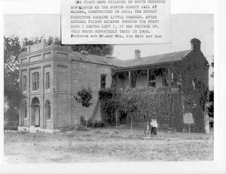
Benton County is a county located in the west central part of the U.S. state of Missouri. The population was 19,056 as of the 2010 Census. Its county seat is Warsaw. The county was organized January 3, 1835, and named for U.S. Senator Thomas Hart Benton of Missouri.
Contents
- 106 acres of pristine ozark country for sale in benton county missouri
- Map of Benton County MO USA
- Geography
- Adjacent counties
- Major highways
- Demographics
- Public schools
- Private schools
- Local
- State
- Federal
- Missouri Presidential Preference Primary 2008
- Communities
- References
Map of Benton County, MO, USA
Geography
According to the U.S. Census Bureau, the county has a total area of 753 square miles (1,950 km2), of which 704 square miles (1,820 km2) is land and 48 square miles (120 km2) (6.4%) is water.
Adjacent counties
Major highways
Demographics
As of the census of 2000, there were 17,180 people, 7,420 households, and 5,179 families residing in the county. The population density was 24 people per square mile (9/km²). There were 12,691 housing units at an average density of 18 per square mile (7/km²). The racial makeup of the county was 97.96% White, 0.15% Black or African American, 0.53% Native American, 0.13% Asian, 0.01% Pacific Islander, 0.12% from other races, and 1.10% from two or more races. Approximately 0.89% of the population were Hispanic or Latino of any race.
There were 7,420 households out of which 23.20% had children under the age of 18 living with them, 59.60% were married couples living together, 6.80% had a female householder with no husband present, and 30.20% were non-families. 26.30% of all households were made up of individuals and 13.80% had someone living alone who was 65 years of age or older. The average household size was 2.28 and the average family size was 2.72.
In the county, the population was spread out with 20.50% under the age of 18, 5.70% from 18 to 24, 21.80% from 25 to 44, 29.70% from 45 to 64, and 22.30% who were 65 years of age or older. The median age was 46 years. For every 100 females there were 98.20 males. For every 100 females age 18 and over, there were 96.70 males.
The median income for a household in the county was $26,646, and the median income for a family was $32,459. Males had a median income of $26,203 versus $19,054 for females. The per capita income for the county was $15,457. About 10.20% of families and 15.70% of the population were below the poverty line, including 24.50% of those under age 18 and 9.60% of those age 65 or over.
Public schools
Private schools
Local
The Republican Party predominantly controls politics at the local level in Benton County. Republicans hold all but one of the elected positions in the county.
State
All of Benton County is a part of Missouri’s 116th District in the Missouri House of Representatives and is represented by Wanda Brown (R-Lincoln).
All of Benton County is a part of Missouri’s 28th District in the Missouri Senate and is currently represented by Mike Parson (R-Bolivar).
Federal
All of Benton County is included in Missouri’s 4th Congressional District and is currently represented by Vicky Hartzler (R-Harrisonville) in the U.S. House of Representatives.