Neha Patil (Editor)

Mojave Road

Updated on
Edit
Like
Comment
Share on FacebookTweet on TwitterShare on LinkedInShare on Reddit
Mojave Road Mojave Road in the Mojave desert DesertUSA

Mojave road october 2016 day 1 3


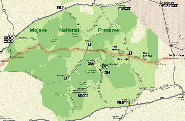
The Mojave Road, also known as Old Government Road formerly the Mohave Trail is a historic route and present day dirt road across what is now the Mojave National Preserve in the Mojave Desert in the United States. This rough road stretched 147 miles (237 km) from Beale's Crossing (the river crossing site on the west bank of the Colorado River, opposite old Fort Mohave, roughly 10 miles (16 km) southwest of Bullhead City, Arizona), to Fork of the Road location along the north bank of the Mojave River where the old Mojave Road split off from the route of the Old Spanish Trail/Mormon Road.

Contents

Mojave Road Mojave Road Wikipedia

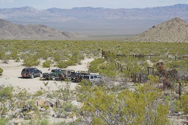
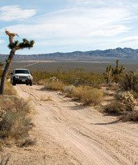
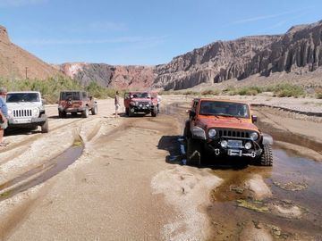
A four-wheel drive vehicle is required for all but a few short stretches of this road, which is unmaintained. The old road from Fork of the Road eastward along the Mojave River is interrupted after 10.9 acres (4.4 ha) by private property, below the site of the old Camp Cady (on the north bank of the Mojave River, roughly 12 miles (19 km) northeast of Newberry Springs, California). The road is resumed at an access point from the north in Manix Wash. Under optimal conditions, its full length of 133 miles (214 km) from Beale's Crossing to Manix Wash can be travelled in 2 to 3 days.

Mojave Road The Mojave Road OffRoadcom

Mojave road 3 days all alone off road


Mohave Trail

Mojave Road httpswwwnpsgovmojaplanyourvisitimagesmoja

A traditional thoroughfare of desert-dwelling Native Americans, the Mohave Trail much later served Spanish missionaries, explorers, and foreign colonizers and settlers from the 18th to 19th centuries who called it the Mojave Trail, and ran between watering holes across the Mojave Desert between the Colorado River and Mojave River then following it to the Cajon Pass, the gap between the San Bernardino Mountains and San Gabriel Mountains, into Southern California. The watering holes recur at intervals of about 60 miles (97 km) to 70 miles (110 km).

Mojave Road Old Mojave Road quotDESERT WRANGLERSquot A Jeep Wrangler Club Henderson

Francisco Garcés, the Spanish Franciscan missionary, traveled the trail with Mohave guides, after leaving the expedition of Juan Bautista de Anza in 1776. José María de Zalvidea, the zealous Franciscan administrator of Mission San Gabriel also crossed the trail in 1806, reportedly converting five indigenous Mohaves near present-day Hesperia. In 1826, Jedediah Smith became the first North American to travel the Mojave Trail.

Old Spanish Trail

From 1829-30, Mexican traders from New Mexico established the routes that came to be called the Old Spanish Trail trade route to California. The first of these Armijo's route intercepted the Mohave's trail at the mouth of the Mojave River near Soda Lake.

Subsequenty in 1830, the Mohave's trail became part of what became the Main Route or Central Route of the Old Spanish Trail, linking up with it from the north 12 miles (19 km) west of the Colorado River in Piute Valley and following it westward to the link up with Armijo's route at the Mojave River mouth, and later with a short cut from Salt Spring through Bitter Spring and Spanish Canyon at a point just east of Yermo. This place was later called "Fork of the Road" where the Old Spanish Trail or from 1849, the Southern Route of the California Trail or the Mormon Road to Salt Lake City, divided from what came to be the Mojave Road to the Colorado River.

Now consolidated the Old Spanish Trail then followed the Mohave's trail along the Mojave River but instead of crossing over the mountains into San Bernardino Valley they followed a new route Armijo called "Cañon de San Bernardino" from the upper Mojave River west through Cajon Pass and down Crowder Canyon and Cajon Canyon, known to the vaqueros of the San Bernardino de Sena Estancia who had come to their aid with food.

Mojave Road

The land passed into American hands in 1848 and in early 1858 the Mohave Trail became the Mojave Road, a wagon road connected to the newly pioneered Beale's Wagon Road across northern New Mexico Territory from Fort Defiance to Beale's Crossing on the Colorado River where it linked up with the Mojave Road. Wagon trains of settlers coming west on the Santa Fe Trail, soon followed Beale's Wagon Road and the Mojave Road into Southern California. Beale's road was shorter than the route via the more southern Southern Emigrant Trail and it was cooler in summer and snow free in winter, had better forage and was better watered. Soon hostiities began between the Mohave's and the settlers, triggering the Mohave War.

From the time of the Mohave War the trail came under the purview of the U.S. government. Army posts were established at Fort Mojave, at Beale's Crossing in 1859 and after the Bitter Spring Expedition at Camp Cady, 10.9 miles (17.5 km) east of Fork of the Road, in 1860. Later in the 1860s, smaller outposts were established east of Camp Cady along the trail and regular patrols instituted. The army protected the settlers and travelers from the attacks of the resident Paiute, Mojave and Chemehuevi Native Americans until 1871. This also opened the way for large mining development in the Mojave Desert region of San Bernardino County and agricultural development in the Victor Valley area.

The route today

The eastern end of the Mojave Road begins at the edge of the Colorado River, near the site of Beale's Crossing, north of Needles and the western terminus lies beyond the Rasor Off-Highway Vehicle Area and the Afton Canyon Natural Area near the Manix Wash.

Landmarks

The following list of markers follows east to west travel.

  • The Colorado River – Where the trail begins, near Beale's Crossing. (mile 0) 35.046280°N 114.627890°W / 35.046280; -114.627890 (The Colorado River)
  • Beaver Lake - A lake, sometimes a slough of the Colorado River during spring floods. The original road passed the lake on the north 2.5 miles (4.0 km) - 3 miles (4.8 km) from the river crossing, in the 19th century. The Mohave War Battle of Beaver Lake was fought there just north of the lake. In the 20th century, cutoff from the spring floods of the river by the construction of dams above it, Beaver Lake dried up, becoming playa, desert or farmland. The modern trail cuts across the middle of this former water feature. 35.070010°N 114.639990°W / 35.070010; -114.639990 (Beaver Lake)
  • Piute Creek – With Piute Spring, a natural spring, as its source, a desert oasis with trees and plants growing all year round, in the Piute Range. (mile 23) 35.115020°N 114.985260°W / 35.115020; -114.985260 (Piute Creek)
  • Fort Piute – Next to the mouth of Piute Creek where the oasis ends, this fort was built in 1867 by the US infantry, one of several to guard the Government Road between Fort Mohave and San Bernardino. (mile 23) 35.115020°N 114.985260°W / 35.115020; -114.985260 (Fort Piute)
  • Lanfair Valley – Cattle ranches have been here since 1880. (mile 34) 35.094780°N 115.019520°W / 35.094780; -115.019520 (Lanfair Valley)
  • Indian Hill 35.143530°N 115.154260°W / 35.143530; -115.154260 (Indian Hill), Indian Well 35.145278°N 115.158889°W / 35.145278; -115.158889 (Indian Well) – About a mile north of the Mojave Road at mile 40, there is Indian Hill, the summit on the south end of the Lanfair Buttes. Indian Well an old well of debatable origin lies to the northwest of Indian Hill.(mile 40)
  • Joshua Tree Forest – The road gets very narrow in this thick forest in Lanfair Valley. (mile 47) 35.143340°N 115.291460°W / 35.143340; -115.291460 (Joshua Tree Forest)
  • Rock Spring – The biggest watering hole along the Mojave Road. The stream flows down large boulders. There is an old cabin here. (mile 49) 35.152830°N 115.327300°W / 35.152830; -115.327300 (Rock Spring)
  • Government Holes – Another water supply near Rock Spring, with an old concrete trough. (mile 52) 35.147490°N 115.359200°W / 35.147490; -115.359200 (Government Holes)
  • Cedar Canyon – The highest point of the trip, crossing the Mid Hills you will reach 5,000 ft (1,500 m) elevation. (mile 56) 35.152900°N 115.362000°W / 35.152900; -115.362000 (Cedar Canyon)
  • Kelso-Cima Road – In the middle of the trip, this is the last paved road you will see for a long time (mile 62) 35.176210°N 115.509010°W / 35.176210; -115.509010 (Kelso-Cima Road)
  • Marl Spring – Another spring with a primitive concrete trough. (mile 70) 35.170700°N 115.647590°W / 35.170700; -115.647590 (Marl Springs)
  • Mojave Road Mail Box – Sign your name at this solitary flagpole and continue on. (mile 74) 35.185400°N 115.692840°W / 35.185400; -115.692840 (Mojave Road Mail Box)
  • Willow Wash – A wash with heavy sands south and west of the Cima Volcanic Range and Volcanic_Fields, parallels Kelbaker Rd. to where it breaks up into distributary washes beyond Seventeen Mile Point. (mile 77) 35.162850°N 115.842090°W / 35.162850; -115.842090 (Willow Wash)
  • Kelbaker Road – The section of the paved road between Baker and Kelso Junction.35.2226°N 115.8789°W / 35.2226; -115.8789 (Kelbaker Road)
  • Seventeen Mile Point - Mountain marking the halfway point between Soda Spring and Marl Spring. Site of Seventeen Mile Point mining camp. 35.22165°N 115.89296°W / 35.22165; -115.89296 (Seventeen Mile Point)
  • Soda Lake – A large dry lake; proceed with caution. You may have to drive around in the winter. (mile 97) 35.152410°N 116.052710°W / 35.152410; -116.052710 (Soda Lake)
  • Soda Springs in (Zzyzx) – Small private building on the edge of Soda Lake. 35.142790°N 116.104740°W / 35.142790; -116.104740 (Soda Springs (Zzyzx))
  • Travelers Monument – Also known as Government Monument, travelers carry a rock across the dry lake and add it to the pile. (mile 100) 35.130840°N 116.095270°W / 35.130840; -116.095270 (Travelers Monument)
  • Rasor OHV Area – Open use area. (mile 103) 35.108780°N 116.143630°W / 35.108780; -116.143630 (Rasor OHV Area)
  • Sand Dunes – There are a few soft sand dunes along here that you can play on. (mile 106) 35.080507°N 116.193786°W / 35.080507; -116.193786 (Sand Dunes)
  • Afton Canyon – Deep canyon with steep walls, riparian habitat restoration, and plenty of scenery. (mile 116) 35.042720°N 116.309500°W / 35.042720; -116.309500 (Afton Canyon)
  • Mojave River crossing – The only water crossing on this trail. (mile 121) 35.037740°N 116.381120°W / 35.037740; -116.381120 (Mojave River)
  • Manix Wash – The exit point of the Mojave Road. (mile 133) 34.974380°N 116.540800°W / 34.974380; -116.540800 (Manix Wash)
  • Camp Cady – a former U.S. Army Camp along the old Mojave Road, on the Mojave River (mile 136.1) 34.946111°N 116.589444°W / 34.946111; -116.589444 (Camp Cady)
  • Fork of the Road – Location along the north bank of the Mojave River were the old Mojave Road split off from the route of the Old Spanish Trail/Mormon Road east of Yermo. (mile 147) 34.901389°N 116.759722°W / 34.901389; -116.759722 (Fork of the Road)
  • References

    Mojave Road Wikipedia