
Local time Tuesday 7:13 AM | ||
 | ||
Weather 1°C, Wind SE at 8 km/h, 41% Humidity | ||
Miran is an ancient oasis town located on the southern rim of the Taklamakan Desert in the Xinjiang Uyghur Autonomous Region of the China. It lies on the famous trade route known as the Silk Road where the Lop Nur desert meets the Altun Shan mountains. Two thousand years ago a river flowed down from the mountain and Miran had a sophisticated irrigation system. Now the area is a sparsely inhabited dusty spot with poor roads and minimal transportation. Archaeological excavations since the early 20th century have uncovered an extensive Buddhist monastic site that existed between the 2nd to 5th centuries AD, as well as Miran fort which was a Tibetan settlement during the 8th and 9th centuries AD.
Contents
Names
Lionel Giles has recorded the following names for Miran (with his Wade-Giles forms of the Chinese names converted to pinyin):
"Yuni, old capital of Loulan [Former Han]"Old Eastern Town" ; "Little Shanshan" [Later Han]Qitun Cheng ; Tun Cheng [Tang]Mirān [modern name].During the period of Tibetan occupation (mid-8th to mid-9th centuries), the area was known as Nop Chungu (nob chu ngu).
History
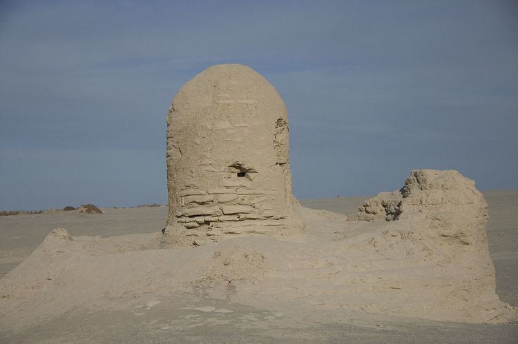
In ancient times Miran was a busy trading center on the southern part of the Silk Road, after the route split into two (the northern route and the southern route), as caravans of merchants sought to escape travel across the harsh wasteland of the desert (called by the Chinese "The Sea of Death") and the Tarim Basin. They went by going around its north or south rim. It was also a thriving center of Buddhism with many monasteries and stupas. Buddhist devotees would have walked around the covered circular stupas, whose central pillar contained relics of the Buddha.
Miran was one of the smaller towns in Kroraina (also known as Loulan), which was brought under the control of the Chinese Han Dynasty in the third century. After the fourth century the trading center declined. In the mid eighth century, Miran became a fort town because of its location at the mouth of a pass on one of the routes into Tibet. This is where the Tibetan forces crossed when the Chinese army withdrew to deal with rebels in central China. The Tibetans remained there, using the old irrigation system, until the Tibetan Empire lost its territories in Central Asia around the middle of the ninth century.
Archaeology
The ruins at Miran consist of a large rectangular fort, a monastery ('the Vihara' in Stein's accounts), several stupas and many sun-dried brick constructions, located relatively close to the ancient caravan track to Dunhuang, running west to east. The many artifacts found in Miran demonstrate the extensive and sophisticated trade connections these ancient towns had with places as far away as the Mediterranean Sea. Archaeological evidence from Miran shows the influence of Buddhism on artistic work as early as the first century BC. Early Buddhist sculptures and murals excavated from the site show stylistic similarities to the traditions of Central Asia and North India and other artistic aspects of the paintings found there suggest that Miran had a direct connection with Rome and its provinces. This Romanesque style is thought to be the work of a Buddhist painter known as Tita (Titus), who was perhaps a Roman artist who traveled east along the Silk Roads in search of employment. Several artefacts have been found at the Miran site, including bows and arrows.