
 | ||
The Mexico–United States border is an international border separating Mexico and the United States, from California in the west to Texas in the east. The border traverses a variety of terrains, ranging from major urban areas to uninhabitable deserts, and is the most frequently crossed in the world, with approximately 350 million legal crossings annually (2010).
Contents
- Border region
- Border states
- Border crossing checkpoints
- History
- Background
- USMexico border enforcement
- Border incursions
- Disagreements over need for more resources
- Effect on US presidential election and aftermath of Inauguration of Donald Trump
- Department of Homeland Security Secure Border Initiative
- 100 mile border zone
- Operation Streamline
- Support and criticisms
- Western Hemisphere Travel Initiative
- MexicoUnited States barrier
- Veterinary inspections
- Crossing from Mexico to the United States
- Crossing from the United States to Mexico
- References
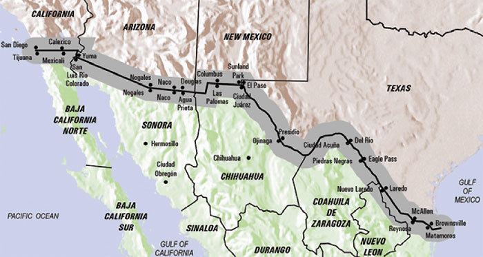
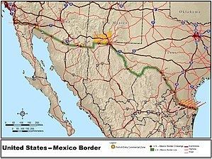
The total length of the continental border is 3,201 kilometres (1,989 mi). From the Gulf of Mexico, it follows the course of the Rio Grande (Río Bravo del Norte) to the border crossing at Ciudad Juárez, Chihuahua and El Paso, Texas; westward from El Paso-Juarez, it crosses vast tracts of the Chihuahuan and Sonoran Deserts to the Colorado River Delta, westward to San Diego-Tijuana, before reaching the Pacific Ocean.
Border region
Following the Boundary Treaty of 1970 between the United States and Mexico that settled all the pending boundary disputes and uncertainties related to the Rio Grande (Río Bravo del Norte) border, the national continental border extends 3,145 kilometers (1,954 mi), excluding the maritime boundaries of 29 km (18 mi) in the Pacific Ocean and 19 km (12 mi) in the Gulf of Mexico.
According to the International Boundary and Water Commission, this continental border follows the middle of the Rio Grande—according to the 1848 Treaty of Guadalupe Hidalgo between the two nations, "along the deepest channel" (also known as the thalweg)—from its mouth on the Gulf of Mexico a distance of 2,019 km (1,255 mi) to a point just upstream of El Paso and Ciudad Juárez. It then follows an alignment westward overland and it is marked by monuments for a distance of 859 km (534 mi) to the Colorado River, when it reaches its highest elevation at the intersection with the Continental Divide. Thence it follows the middle of that river northward a distance of 38 km (24 mi), and then it again follows an alignment westward overland and marked by monuments a distance of 227 km (141 mi) to the Pacific Ocean (excluding the maritime boundaries of 18 miles (30 km) in the Pacific Ocean and 12 miles (20 km) in the Gulf of Mexico).
The official 'border region' extends 60 km (37 mi) north and south of the aforementioned boundaries and 60 km (37 mi) east into the Gulf of Mexico and 60 km (37 mi) west into the Pacific Ocean.

The region is characterized by deserts, rugged hills, abundant sunshine, and two major rivers—the Colorado and the Rio Grande (Río Bravo del Norte)—which provide life-giving waters to the largely arid but fertile lands along the rivers in both countries.
Border states
The U.S. states along the border, from west to east, are California, Arizona, New Mexico, and Texas. The Mexican states are Baja California, Sonora, Chihuahua, Coahuila, Nuevo León, and Tamaulipas.
In the United States, Texas has the longest stretch of the border of any state, while California has the shortest. In Mexico, Chihuahua has the longest border, while Nuevo León has the shortest.
Texas borders four Mexican states—Tamaulipas, Nuevo León, Coahuila, and Chihuahua—the most of any U.S. state. New Mexico and Arizona each border two Mexican states (Chihuahua and Sonora; Sonora and Baja California, respectively). California borders only Baja California. Texas is more adjacent to Mexico than California.
Three Mexican states border two U.S. states each: Baja California borders California and Arizona; Sonora borders Arizona and New Mexico; and Chihuahua borders New Mexico and Texas. Tamaulipas, Nuevo León, and Coahuila each border only one U.S. state: Texas.
Border crossing checkpoints
The border separating Mexico and the United States is the most frequently crossed international boundary in the world, with approximately 350 million legal crossings being made annually.
There are 48 U.S.–Mexico border crossings, with 330 ports of entry. Crossings include roads, pedestrian walkways, railroads and ferries. From west to east, below is a list of the border city "twinnings"; cross-border municipalities connected by one or more legal border crossings.
The total population of the borderlands—defined as those counties and municipios lining the border on either side—stands at some 12 million people.
History
In the mid-16th century, with the discovery of silver, settlers from a variety of countries and backgrounds began to arrive in the area. This period of sparse settlement included colonizers from different backgrounds. The area technically was part of the Kingdom of New Spain, but due to the lack of population and the diverse citizenry it had, it did not seem to belong to any country. This period lasted until the early 19th century, at which point the United States bought the lands known as the Louisiana Purchase from France and began to expand steadily (militarily) westward in its pursuit of Manifest Destiny.
The border itself was not clearly defined and remained so until the Mexican colony became independent from Spain and entered a period of political instability. Mexico attempted to create a buffer zone at the border that would prevent possible invasion from the North. The Mexican government encouraged thousands of their own citizens to settle in the region that is now known as Texas and even offered inexpensive land to settlers from the United States in exchange for populating the area. The influx of people did not provide the defense that Mexico had hoped for and instead Texas declared its independence in 1836. That independence lasted until 1845 when the United States annexed Texas.
The constant conflicts in the Texas region in the mid-19th century eventually led to the Mexican–American War, which began in 1846 and ended in 1848 with the Treaty of Guadalupe Hidalgo. In the terms of the peace treaty, Mexico lost more than 960,000 square miles (2,500,000 km2) of land, 55% of its national territory, including what is today California, Arizona, New Mexico, Utah, Nevada and parts of Colorado, Wyoming, Kansas, and Oklahoma. In addition, all disputes over Texas and the disputed territory between Rio Grande and Rio Nueces were abandoned. Five years later the Gadsden Purchase completed the creation of the current United States–Mexico border. The purchase was initially to accommodate a planned railway right-of-way. These purchases left approximately 300,000 people living in the once disputed lands, many of whom were Mexican nationals. Following the establishment of the current border a number of towns sprang up along this boundary and many of the Mexican citizens were given free land in the northern regions of Mexico in exchange for returning and repopulating the area.
The Treaty of Guadalupe Hidalgo and another treaty in 1884 were the agreements originally responsible for the settlement of the international border, both of which specified that the middle of Rio Grande was the border—irrespective of any alterations in the channels or banks. The Rio Grande shifted south between 1852 and 1868, with the most radical shift in the river occurring after a flood in 1864. By 1873 the moving river-center border had cut off approximately 600 acres (2.4 km2) of Mexican territory in the El Paso-Juarez area, in effect transferring the land to the United States. By a treaty negotiated in 1963, Mexico regained most of this land in what became known as the Chamizal dispute and transferred 264 acres (1.07 km2) in return to the United States. Border treaties are jointly administered by the International Boundary and Water Commission (IBWC), which was established in 1889 to maintain the border, allocate river waters between the two nations, and provide for flood control and water sanitation. Once viewed as a model of international cooperation, in recent decades the IBWC has been heavily criticized as an institutional anachronism, by-passed by modern social, environmental and political issues.
The economic development of the border region on the Mexican side of the border depended largely on its proximity to the United States, due to its remoteness from commercial centers in Mexico. During the years of Mexican President Porfirio Díaz, between 1876 and 1910, the border communities boomed, due mostly to close ties to the United States, and the Mexican government's support for financial investments from the United States. Railroads were built that connected the northern Mexican states more to the United States than to Mexico and the population grew tremendously. The mining industry also developed, as did the United States’ control of it. By the early 20th century companies from the United States controlled 81% of the mining industry and had invested five hundred million dollars in the Mexican economy overall, twenty-five percent of it in the border regions.
The Mexican Revolution, caused at least partially by animosity towards foreign ownership of Mexican properties, began in 1910. The Revolution increased the political instability in Mexico, but did not significantly slow United States investment. It did reduce economic development within Mexico, however, and the border regions reflected this. As the infrastructure of communities on the United States side continued to improve, the Mexican side began to fall behind in the construction and maintenance of important transportation networks and systems necessary to municipal development.
Background
The United States–Mexican border, with its 1951 miles in length, has a very high rate of legal and illegal migrant crossings every year. With such a high rate of people crossing yearly to the United States, the country has invested in several distinct security measures. The U.S. Border Patrol is perhaps the most important security measure. In 2010, due to insecurity and instability at the southern border of the U.S., president Barack Obama signed an appropriation bill, which gave the CBP (Customs and Border Protection), specifically the Border Patrol, 600 million dollars to implement and improve security. Even though the United States' government has invested many millions of dollars on border security, this does not and has not completely stopped undocumented Latino/a people (especially Mexicans) from entering the country.
US–Mexico border enforcement
The U.S.–Mexico border has the highest number of registered legal crossings of any land border in the world. Over five million cars and trucks travel through the border annually. According to Vulliamy, one in five Mexican nationals will visit or work in the United States at one point in their lifetime. As of 2010, the border is guarded by more than twenty thousand Border Patrol agents, more than at any time in its history. However, they only have "effective control" of less than 700 miles (1,100 km) of the 1,954 miles (3,145 km) of total border, with an ability to actually prevent or stop illegal entries along 129 miles (208 km) of that border. The border is paralleled by United States Border Patrol Interior Checkpoints on major roads generally between 25 and 75 miles (121 km) from the U.S. side of the border, and garitas generally within 50 km of the border on the Mexican side.
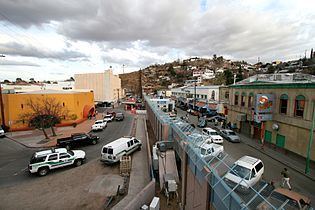
There are an estimated half a million illegal entries into the United States each year. Border Patrol activity is concentrated around big border cities such as San Diego and El Paso which do have extensive border fencing. This means that the flow of illegal aliens is diverted into rural mountainous and desert areas, leading to several hundred migrant deaths along the Mexico–U.S. border of those attempting to cross into the United States from Mexico illegally and vice versa.
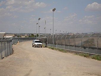
The Secure Fence Act of 2006 was passed providing for the construction of 700 miles (1,100 km) of high-security fencing. Attempts to complete the construction of the United States–Mexico barrier have been challenged by the Mexican government and various U.S.–based organizations.
In January 2013, the Government Accountability Office released a report stating that the United States Border Patrol only intercepted sixty-one percent of individuals illegally crossing the border in 2011, which translated to 208,813 individuals not apprehended. 85,827 of the 208,813 would go on to illegally enter the United States, while the rest returned to Mexico and other Central American countries. The report also showed that the number of illegal border crossings has dropped.
Border incursions
According to the United States Border Patrol, in the fiscal year of 2006, there were twenty-nine confirmed border incursions by Mexican government officials, of which seventeen were by armed individuals. Since 1996 there have been 253 incursions by Mexican government officials. In 2014, United States Department of Homeland Security informed United States Representative Duncan D. Hunter, that since 2004, there have been 300 documented border incursions, which resulted in 131 individuals being detained.
The Washington Times has reported that on Sunday, August 3, 2008, Mexican military personnel who crossed into Arizona from Mexico encountered a U.S. Border Patrol agent, whom they held at gunpoint. The soldiers later returned to Mexico, as backup Border Patrol agents came to investigate.
Disagreements over need for more resources
Proponents of greater spending on the border – especially politicians from border states – argue that continuing the buildup is necessary due to increased violence and drug trafficking from Mexico spilling over into the United States. However, critics such as the Washington Office on Latin America (WOLA) have argued that further buildup will have fewer desired effects and may even be counterproductive. Furthermore, WOLA has emphasized that the diminishing number of border crossings can only be partially attributed to US security measures. Unintentional factors, such as a weakened US economy in the wake of the 2008 financial crisis and increased violence in the north of Mexico, have made attempting illegal border crossings more risky and less rewarding.
Effect on US presidential election and aftermath of Inauguration of Donald Trump
In 2016, Donald Trump, then a Republican presidential nominee in the forthcoming US election, repeatedly stated that he wanted to build a wall along the US–Mexico border, for the purpose of immigration control. He declared that Mexico was to be forced to pay for the whole wall. Following his Inauguration as 45th President of the United States on January 20, 2017, on January 25 President Trump signed an Executive Order to enable the building of the wall. Shortly afterwards, the Mexican president stated that Mexico will not pay for the wall, and on January 26, Trump announced that he intended to propose a 20% tax on imported Mexican goods to pay for the wall. This came shortly after the Mexican president cancelled a meeting with President Trump that was to begin on January 27 in Washington DC.
Department of Homeland Security Secure Border Initiative
A National Border Patrol Strategic Plan was first developed in 1994 to deal with the perception that borders were being overrun by illegal immigrants and drug dealers. It was then updated in 2004 and 2012. In 2004 the updated strategy focused on command structures, intelligence and surveillance, enforcement and deployment of U.S. Border Patrol agents to better respond to threats at the border. The strategic planning led to broader policy development for the Department of Homeland Security which led to the Secure Border Initiative (SBI) in 2005 to secure U.S. borders and reduce illegal migration. The main components of SBI dealt with staffing concerns, removal capacity, surveillance and tactical infrastructure and interior enforcement.
An additional component was “high consequence enforcement”, which was not the subject of a formal public policy document. There was the allowance, historically, for voluntary returns of individuals apprehended at the border by Border Patrol agents. These voluntary returns, after the SBI of 2005, were limited to three “high consequence outcomes”.
One "high consequence outcome" was formal removal, which meant the individual would be deemed ineligible for a visa for at least five years and subject to criminal charges if caught re-entering illegally. The Immigration and Nationality Act permitted aliens to be formally removed with “limited judicial processing” known as expedited removal. The Department of Homeland Security has expanded between 2002 and 2006, expedited removal for “certain aliens that entered within previous two weeks and were apprehended within 100 miles (160 km) of the border”.
Another “high consequence outcome” is the increase in criminal charges. Department of Homeland Security has also worked with the Department of Justice to increase the number of apprehended individuals crossing the border illegally who are charged with criminal offenses. Most of these cases are prosecuted under Operation Streamline. The third “high consequence outcome” is known as remote repatriation. This is the return of apprehended Mexicans to remote locations by Border Patrol rather than the nearest Mexican port of entry.
100-mile border zone
Regulations establishing the 100-mile (160 km) zone were adopted by the U.S. Department of Justice as the result of an interpretation of the Immigration and Nationality Act in 1953. Customs and Border Protection’s (CBP) officials have authority for stop and search within this 100 miles (160 km) from any external boundary. This allows for CBP officials to enter private property without a warrant within 25 miles (40 km) of the border as well as the operation of checkpoints.
The Fourth Amendment of the U.S. Constitution protects against unreasonable search and seizure; however, according to the government this Amendment does not fully apply at borders or border crossings (also known as ports of entry). This means that much of the U.S. population is subject to CBP regulations for stop and search. The 100 Mile Border Zone includes two thirds of the population, a majority of the largest cities in the U.S. and several entire states (namely Connecticut, Delaware, Florida, Hawaii, Maine, Massachusetts, Michigan, New Hampshire, and New Jersey).
There are some limits to CBP officials ability to stop and search. For instance CBP officials are not allowed to pull anyone over without a reasonable suspicion of immigration violation or crime, or search vehicles without warrant or probable cause. The ACLU, however, found that CBP officials routinely ignore or misunderstand the limits of authority, and this is compounded by inadequate training, lack of oversight and failure to hold officials accountable for abuse—incidence of abuse is common.
Operation Streamline
Operation Streamline refers collectively to zero-tolerance policies implemented at the U.S.-Mexico border that seek to remove undocumented immigrants through an expedited process if they have arrived with missing or fraudulent identification or have previously been convicted for an immigration crime.
History
Operation Streamline was first implemented in Del Rio, Texas, in 2005. The program has since expanded to four out of the five federal judicial districts on the U.S.-Mexico border: Yuma, AZ; Laredo, TX; Tucson, AZ; and Rio Grande Valley, TX.
Previously, immigrants apprehended at the border were either given the option to voluntarily return to their home country or they were placed in civil immigration proceedings. After Operation Streamline was implemented, nearly all people apprehended at the border who are suspected of having crossed illegally are subject to criminal prosecution. Defendants who are charged with crossing into the U.S. illegally are tried en masse to determine their guilt. Defense attorneys often are responsible for representing anywhere from six to forty immigrants at once. Around 99% of defendants in Operation Streamline proceedings plead guilty. The defendants are charged with a misdemeanor if convicted of crossing the border illegally for the first time, and a felony if it is a repeat offense.
In December 2009, it was decided in United States v. Roblero-Solis that en masse judicial proceedings like those in Operation Streamline violated Rule 11 in the Federal Rules of Criminal Procedure. Rule 11 states that the court must determine that a guilty plea is voluntarily made by addressing the defendant personally in court. The Roblero-Solis case determined that “personally” means that the judge must address the defendant in a person-to-person manner. Though many courts have changed their procedures to adapt to the ruling, there are still forms of en masse trials practiced at the border.
Support and criticisms
Proponents of Operation Streamline claim that the harsher prosecution has been an important factor in deterring immigrants from crossing the border illegally. Apprehensions have decreased in certain sectors after 2005, which is seen as a sign of success. For example, the Del Rio, Texas sector saw a decline from 2005 to 2009 of 75% (from 68,510 to 17,082). Similarly, apprehensions declined in Yuma, Arizona by 95% (from 138,438 to 6,951) from 2006 to 2009.
Criticisms of Operation Streamline point to the program’s heavy use of federal court and enforcement resources as a negative aspect. In addition, the prosecution of all illegal border crossings takes the focus away from prosecuting more serious crimes. They claim that the program’s cost is too high for the effectiveness of the work it is accomplishing. In response to the claim that Operation Streamline is an effective deterrent, critics of the program claim that the incentives to cross the border in order to work or be with family are much stronger.
History
The Agreement on Cooperation for the Protection and Improvement of the Environment in the Border Area, known as the La Paz Agreement, was signed into law on August 14, 1983, and became enforceable on February 16, 1984. This agreement to protect the environment is the political foundation between the U.S. and Mexico for 4 subsequent programs. Each program has addressed environmental destruction in the border region resulting from the rise of the maquiladora industries, those who migrated to Northern Mexico to work in the industries, the lack of infrastructure to accommodate the people, Mexico's lax regulations concerning all these factors, the resulting spillover into the U.S., and the U.S.'s own environmentally destructive tendencies. The programs were: IBEP (1992), Border XXI (1996), Border 2012 (2003) and Border 2020 (2012).
Western Hemisphere Travel Initiative
In late 2006, the United States Department of Homeland Security (DHS) announced a rule regarding new identification requirements for U.S. citizens and international travelers entering the United States implemented on January 23, 2007; this final rule and first phase of the WHTI specifies nine forms of identification—one of which is required to enter the United States by air: a valid passport; a passport card; a state enhanced driver's license or state enhanced non-driver ID card (available in Michigan, New York, Vermont, and Washington) approved by the Secretary of Homeland Security; a trusted traveler program card (NEXUS, FAST, or SENTRI); an enhanced tribal identification card; a Native American Tribal Photo Identification Card; Form I-872 – American Indian Card; a valid Merchant Mariner Document when traveling in conjunction with official maritime business; or a valid U.S. military identification card when traveling on official orders.
The Mexico–United States border is the world's busiest border, specifically the crossing at San Diego, California to Tijuana, Mexico (15.6 miles between the cities), known as the San Ysidro Port of Entry. In the U.S., Interstate 5 crosses directly to Tijuana, and the highway's southern terminus is this crossing. In 2005, more than 17 million vehicles and 50 million people entered the U.S. through San Ysidro. Among those who enter the United States through San Ysidro are "transfronterizos", American citizens who live in Mexico and attend school in the United States.
Along the Mexican coast of Baja California, there are neighborhoods of Americans living in Tijuana, Rosarito Beach, and Ensenada, whose residents commute to the United States daily to work. Additionally, many Mexicans also enter the United States to commute daily to work. In 1999, 7.6% of the labor force of Tijuana was employed in San Diego.
Mexico–United States barrier
The U.S. government had plans in 2006, during the Bush administration, to erect a border fence along the U.S.–Mexico border. The controversial proposal included creating many individual fences. Almost 600 miles (970 km) of fence was constructed, with each of the individual fences composed of steel and concrete. In between these fences are infrared cameras and sensors, National Guard soldiers, and SWAT teams on alert, giving rise to the term "virtual fence". Construction on the fence began in 2006, with each mile costing the U.S. government about $2.8 million. In 2010, the initiative was terminated due to costs, after having completed 640 miles (1,030 km) of either barrier fence or vehicle barriers, that were either new or had been rebuilt over older, inferior fencing. The Boeing-built SBI-net systems of using radar, watchtowers, and sensors (without a fence or physical barrier) were scrapped for being over budget, full of glitches, and far behind schedule.
Veterinary inspections
When animals are imported from one country to another, there is the possibility that diseases and parasites can move with them. Thus, most countries impose animal health regulations on the import of animals. Most animals imported to the United States must be accompanied by import permits obtained in advance from the U.S. Department of Agriculture's Animal and Plant Health Inspection Service (APHIS) and/or health certification papers from the country of origin.
Veterinary inspections are often required, and are available only at designated ports; advance contact with port veterinarians is recommended. Animals crossing the United States–Mexico border may have a country of origin other than the country where they present for inspection. Such animals include those from the U.S. that cross to Mexico and return, and animals from other countries that travel overland through Mexico or the U.S. before crossing the border.
Crossing from Mexico to the United States
APHIS imposes precautions to keep out several equine diseases, including glanders, dourine, equine infectious anemia (EIA), equine piroplasmosis (EP), Venezuelan equine encephalitis (VEE), and contagious equine metritis (CEM). APHIS also checks horses to prevent the introduction of ticks and other parasites. In the Lower Rio Grande Valley, U.S. Department of Agriculture inspectors look for horses and livestock that stray across the border carrying ticks. These animals are often called wetstock, and the inspectors are referred to as tickriders.
Per APHIS, horses originating from Canada can enter the United States with a Canadian government veterinary health certificate and a negative test for EIA. Horses from Mexico must have a health certificate; pass negative tests for EIA, dourine, glanders, and EP at a USDA import center; and undergo precautionary treatments for external parasites at the port of entry. Horses from other Western Hemisphere countries must have the same tests as those from Mexico and, except for horses from Argentina, must be held in quarantine for at least seven days as a check for VEE.
APHIS imposes similar testing and certification requirements on horses from other parts of the world but without the quarantine for VEE. These horses are held in quarantine—usually three days—or until tests are completed. Because the disease equine piroplasmosis (equine babesiosis) is endemic in Mexico but not established in the United States, transportation of horses from Mexico to the United States requires evaluation of horses for the presence of this disease.
Transportation of horses from Mexico to the United States normally requires at least three days in quarantine, which is incompatible with most recreational equestrian travel across the border. A leading exception to this rule is the special waiver obtained by riders participating in the Cabalgata Binacional Villista (see cavalcade).
Crossing from the United States to Mexico
Import from the United States to Mexico requires evidence within the prior 45 days of freedom from equine infectious anemia, among other requirements. In August 2015, Mexico began enforcing a rule that all non-Mexican citizens that plan to stay in Mexico for more than seven days or are travelling on business will have to pay a 330 peso fee ($21 USD) and show their passport.