
Country United States Time zone Mountain (MST) (UTC-7) Elevation 1,528 m Local time Thursday 6:24 AM | State Idaho Village 1917 ZIP codes 83635, 83638 Population 2,925 (2013) University McCall College | |
 | ||
Weather 3°C, Wind SW at 13 km/h, 84% Humidity | ||
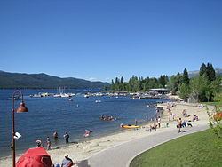
Mccall idaho
McCall is a resort town on the western edge of Valley County, Idaho, United States. Named after its founder, Tom McCall, it is situated on the southern shore of Payette Lake, near the center of the Payette National Forest. The population was 2,991 as of the 2010 census, up from 2,084 in 2000.
Contents
- Mccall idaho
- Map of McCall ID 83638 USA
- 660 migratory ridge mccall idaho
- Geography
- Transportation
- History
- Alpine skiing
- 2010 census
- 2000 census
- Population history
- Government
- Media
- Climate
- Area information
- Notable people
- References
Map of McCall, ID 83638, USA
Originally a logging community whose last sawmill closed in 1977, McCall is now an all-season tourist destination for outdoor recreation. The resort town is known for its Winter Carnival, extended winters, and one of the highest average snowfalls in the state.
660 migratory ridge mccall idaho
Geography
McCall is located at 44°54′39″N 116°6′11″W (44.910906, -116.103087), at an elevation of 5,013 feet (1,528 m) above sea level.
According to the United States Census Bureau, the city has a total area of 10.09 square miles (26.13 km2), of which, 9.23 square miles (23.91 km2) is land and 0.86 square miles (2.23 km2) is water.
Transportation
McCall is approximately 100 miles (160 km) north of Boise, about a 2-hour drive, accessed via State Highway 55, the Payette River Scenic Byway, a designated national scenic byway. It heads north from Eagle in Ada County to Horseshoe Bend in Boise County, and climbs the whitewater of the Payette River to Cascade and McCall. The route turns west at Payette Lake in McCall and ends at New Meadows in Adams County, at the junction with US-95.
The McCall Municipal Airport is on the south edge of town, at an elevation of 5,021 feet (1,530 m) above sea level. West of Highway 55, it is home to a U.S. Forest Service smokejumper base.
History
Native Americans were the first inhabitants of the land in and around McCall. Three tribes, the Tukudika (a sub-band of the Shoshone known as the "Sheepeaters"), the Shoshone, and the Nez Perce inhabited the land primarily in the summer and migrated during the harsh winter months.
In the early 19th century, the nomadic French Canadian fur trapper, François Payette, roamed the area alongside other mountain men including Jim Bridger, Peter Skene Ogden, and Jedediah Smith.
During the 1860s, miners temporarily named the settlement "Lake City", but only alluvial gold was discovered, so the temporary establishment was abandoned as most mining activity moved fifty miles (80 km) north to the town of Warren.
The settlement of McCall was established by Thomas and Louisa McCall circa 1889-91. For a cabin and assumed rights to the 160 acres (0.65 km2) of land, they traded a team of horses with Sam Dever, who held the squatter rights. Tom, his wife, four sons and a daughter lived in the cabin located on the shore of the lake, near present-day Hotel McCall. He established a school, hotel, saloon, and post office, and named himself postmaster. McCall purchased a sawmill from the Warren Dredging company and later sold it to the Hoff & Brown Lumber Company, which would become a major employer until its closure in 1977.
During this time Anneas "Jews Harp Jack" Wyatte provided the first recreational sailboat rides around the lake for tourists and advertised in Boise's Idaho Statesman a "30-foot sailing yacht for the use of parties who might visit the lake". The Statesman referred to McCall as a "pleasure resort."
Tourism continued in the early 20th century. In June 1902, the Boydstun Hotel in nearby Lardo opened as a "place to stay and camp on Payette Lake". In 1906, Charlie Nelson opened a tented camping area known as Sylvan Beach Resort along the west side of Payette Lake. In 1907, Lardo Inn opened for business. The arrival of the Oregon Short Line Railroad (a subsidiary of the Union Pacific Railroad) in 1914 secured McCall as a viable community and tourist destination. Three years later McCall was incorporated as a village. In the 1920s, the state land board started leasing homesites along the lake.
The town's annual winter carnival started in 1923-24. Reports vary between hundreds to thousands of tourists visiting the festivities.
The beauty of McCall and Payette Lake drew attention from Hollywood in 1938 when it was selected as the filming location for the Academy Award-nominated Northwest Passage, starring Spencer Tracy, Robert Young, and Walter Brennan. The film, released in 1940, was about the French and Indian War of 1755–63 in eastern North America; the forests of Idaho standing in for the woods of New England and the Upper Midwest.
In 1943, the U.S. Forest Service opened the McCall smokejumper base, one of eight smokejumper training bases in the nation. The site includes a smokejumper training unit, paraloft, dispatch office, and the McCall air tanker base at the airport.
After World War II, a consortium of businessmen and doctors from Lewiston, 150 miles (240 km) to the north, decided that McCall and the lake were an ideal recreation site and thus the town was transformed from lumber to tourism. The iconic Shore Lodge opened in 1948 on July 3, along Shellworth Beach on Payette Lake. The lodge became McCall's centerpiece for the next 51 years. Shore Lodge management and shareholders intentionally created a resort-style lodge that was a cozy and intimate place for locals and tourists, contrasting with the glamor and glitz of the other famous Idaho lodge in Sun Valley. A private club for nearly a decade, it re-opened to the public in 2008. One of Shore Lodge's first summer employees was University of Idaho student John Ascuaga of Notus, who worked as a bellhop learning the business from the bottom up and was to go on to found the Nugget hotel, convention center, and casino in Sparks, Nevada, one of the largest and most successful in the Reno area.
In 1965, a 1,000 acres (4.0 km2) peninsula 2 miles (3 km) outside of McCall became Ponderosa State Park, home to some of the largest old-growth trees in the western United States.
Alpine skiing
McCall's Little Ski Hill, formerly the "Payette Lakes Ski Area," is two miles (3 km) west of town on Highway 55, just over the county line in Adams County. Opened in 1937 as a diversion for local forest workers, its 76 acres (310,000 m2) were donated by Carl Brown. The Little Ski Hill was the second ski area in Idaho, after Sun Valley, which opened a year earlier. It currently operates a T-bar surface lift and has a vertical drop of 405 feet (123 m), with a summit of 5,600 feet (1,710 m) above sea level, and its slopes face north and west. The aging Nordic ski jump on the lower north slope, overlooking the bend in Highway 55, was removed in the 1990s.
Brundage Mountain, northwest of McCall, opened in November 1961. With the addition of two new lifts in summer 2007, it currently has five chairlifts. Brundage has a summit elevation of 7,640 feet (2,330 m) above sea level, and a vertical drop of 1,800 feet (550 m). The slopes on Brundage Mountain are primarily west-facing and the mountain's average snowfall exceeds 300 inches (760 cm). The resort operates a backcountry snowcat skiing operation which provides guided access to 13,000 acres (53 km2) of untracked powder in the Payette National Forest north of the ski area. Brundage is a family-owned resort, operated by the DeBoer family, descendants of early McCall pioneers. Until April 2006, it was co-owned by J. R. Simplot.
Tamarack Resort (2004–09) is southwest of McCall, on the west side of Cascade Reservoir. Originally conceived as "Valbois" in the early 1980s, the project was revived as "WestRock" in the late 1990s and ultimately renamed "Tamarack" in 2002. Tamarack opened for lift-served skiing on December 15, 2004 with a summit elevation of 7,660 feet (2,330 m) on West Mountain, up Rock Creek. Its vertical drop was over 2,700 feet (820 m); it used five chairlifts and a poma lift. The slopes on Tamarack faced east, overlooking the Cascade Reservoir and Long Valley. The resort went into bank receivership in February 2008 and ceased operations a year later, on the evening of Wednesday, March 4, 2009. The ski area was closed for the 2009–10 season, but re-opened in December 2010 with limited operations.
2010 census
As of the census of 2010, there were 2,991 people, 1,348 households, and 769 families residing in the city. The population density was 324.1 inhabitants per square mile (125.1/km2). There were 3,581 housing units at an average density of 388.0 per square mile (149.8/km2). The racial makeup of the city was 93.6% White, 0.1% African American, 0.7% Native American, 0.5% Asian, 3.6% from other races, and 1.4% from two or more races. Hispanic or Latino of any race were 6.9% of the population.
There were 1,348 households of which 25.1% had children under the age of 18 living with them, 45.3% were married couples living together, 7.2% had a female householder with no husband present, 4.5% had a male householder with no wife present, and 43.0% were non-families. 33.5% of all households were made up of individuals and 8.2% had someone living alone who was 65 years of age or older. The average household size was 2.19 and the average family size was 2.80.
The median age in the city was 40.7 years. 21% of residents were under the age of 18; 6.9% were between the ages of 18 and 24; 27.5% were from 25 to 44; 31.1% were from 45 to 64; and 13.5% were 65 years of age or older. The gender makeup of the city was 51.7% male and 48.3% female.
2000 census
As of the census of 2000, there were 2,084 people, 902 households, and 549 families residing in the town. The population density was 352.4 people per square mile (136.1/km²). There were 2,247 housing units at an average density of 379.9 per square mile (146.8/km²). The racial makeup of the town was 96.83% White, 0.05% African American, 0.48% Native American, 0.14% Asian, 1.34% from other races, and 1.15% from two or more races. 2.59% of the population were Hispanic or Latino of any race. 19.2% were of German, 17.3% English, 10.6% Irish and 8.2% American ancestry according to Census 2000. 98.3% spoke English and 1.7% Spanish as their first language.
There were 902 households out of which 28.8% had children under the age of 18 living with them, 49.2% were married couples living together, 7.9% had a female householder with no husband present, and 39.1% were non-families. 33.3% of all households were made up of individuals and 11.1% had someone living alone who was 65 years of age or older. The average household size was 2.25 and the average family size was 2.86.
In the town the population was spread out with 24.3% under the age of 18, 6.0% from 18 to 24, 24.6% from 25 to 44, 30.7% from 45 to 64, and 14.4% who were 65 years of age or older. The median age was 42 years. For every 100 females there were 104.3 males. For every 100 females age 18 and over, there were 99.9 males.
The median income for a household in the town was $36,250, and the median income for a family was $46,420. Males had a median income of $27,955 versus $26,932 for females. The per capita income for the town was $18,479. 12.2% of the population and 7.0% of families were below the poverty line, including 11.6% of those under the age of 18 and 7.2% of those 65 and older.
Population history
Lardo (now western McCall) had a population of 300 at the 1910 census, its only census entry.
Government
The town has a council-manager form of government with a city manager nominated by the mayor and elected by the city council. The McCall City Council is made up of 4 council members and a mayor elected in an at-large election. During city council meetings, the mayor presides, and all 5 members can vote on any issue. The mayor has no veto powers.
McCall is located in Idaho's 1st congressional district. On the state level, McCall is located in district 8 of the Idaho Legislature. Despite the largest population in Valley County, McCall lost the bid for county seat in 1917 to the more centrally located town of Cascade, nearly thirty miles (50 km) south on Highway 55.
Media
McCall is served by two four-color glossy magazines; McCall Magazine and McCall Home, both of which are published semi-annually. McCall is also served by a weekly newspaper The Star News, published on Thursdays. One radio station, KDZY (98.3 FM Country) is based in the town.
Climate
McCall experiences a dry-summer continental climate (Köppen Dsb) with cold, snowy winters and warm, relatively dry summers.