
Website www.boisecounty.us Founded 1864 | Area 4,939 km² Population 6,795 (2013) Unemployment rate 5.3% (Apr 2015) | |
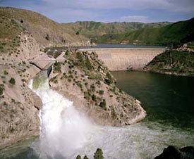 | ||
Points of interest Lucky Peak State Park, Arrowrock Dam, Boise National Forest, Warm Lake, Kirkhams Hot Springs | ||
Boise County is a rural mountain county in the U.S. state of Idaho. As of the 2010 census, the population was 7,028. The county seat is Idaho City, and Horseshoe Bend is its largest city.
Contents
- Map of Boise County ID USA
- Traffic Signal
- History
- Geography
- Adjacent counties
- National protected areas
- Major highways
- 2000 census
- 2010 census
- Population history
- Cities
- Census designated placs
- Unincorporated communities
- References
Map of Boise County, ID, USA
Boise County is part of the Boise, ID Metropolitan Statistical Area.
The Bogus Basin ski area is in the southwestern part of the county. The county's eastern area contains the central section of the Sawtooth Wilderness, the western part of the Sawtooth National Recreation Area.
In 2010, the center of Idaho's population was in Boise County.
Traffic Signal
The closest thing to a traffic signal in Boise County is a flashing red light for Hwy 52 where it meets Highway 55, in Horsehoe Bend. Highway 55 has a flashing yellow.
History
The county was established February 4, 1864, with its county seat at Idaho City. It was named for the Boise River, which was named by French-Canadian explorers and trappers for the great variety of trees growing along its banks in the lower desert valley. The county is also one of four Idaho counties that also existed under Washington Territory. On January 12, 1863, The Washington territorial legislature established the county containing most of Idaho below 114° 30', excluding the territory laying west of the Payette River. They also established its county seat at what would later become Idaho City.
The Boise Basin, in which Idaho City lies, was one of the richest gold mining districts in the nation. Gold was discovered in 1862 and more of it was pulled from present-day Boise County than from the entire state of Alaska. At its peak in the mid-1860s, Idaho City was the largest city in the Northwest, and it was this rapid population influx that lead to the establishment of the Idaho Territory in 1863. The lower elevation communities of Horseshoe Bend (Payette River) and Boise (Boise River) were staging areas for the Boise Basin mines.
The county's boundaries changed frequently during Idaho's territorial period. Owyhee County (Idaho's oldest) and a portion of Oneida County were carved from the southern and eastern portion of the county as it existed under Washington Territory in late December 1863 and January 1864. When Idaho Territory established the county in February, 1864, it contained all of present Ada, Canyon, and Payette counties. It also included most of present Boise and Gem Counties, the southern half of Washington County, and small portions of Adams, Custer, Owyhee, and Valley counties. When Ada County was created later in December 1864, most of that territory was transferred to Ada County, leaving only small portions of Custer, Gem, Payette, Valley, and Washington counties together with most of present-day Boise County. The Boise River portion of the current western boundary was established by 1866. The southern boundary common to present Ada County was defined the following year. The northern boundary was most volatile Between 1873 and 1887 with the boundary shifting further north into Valley County, back south below Cascade, and then again north to include the North Fork of Payette River Basin. The county obtained its current boundary after Gem County was created in 1915 and Valley County in 1918.
In March 2011, the county filed a Chapter 9 bankruptcy petition due to judgment against the county for violating the Fair Housing Act. the county’s Petitions for Chapter 9 relief was denied.
Geography
According to the U.S. Census Bureau, the county has an area of 1,907 square miles (4,940 km2), of which 1,899 square miles (4,920 km2) is land and 7.4 square miles (19 km2) (0.4%) is water. The highest point in the county is Thompson Peak at 10,751 feet (3,277 m), on its eastern border in the Sawtooth Wilderness. The county's lowest point is on the Payette River, on its western border with Gem County, at approximately 2,500 feet (762 m).
Adjacent counties
National protected areas
Major highways
The county's two primary routes are scenic byways. For the majority of their length in the county, both are two-lane undivided highways. The Ponderosa Pine Scenic Byway on State Highway 21 climbs northeast from Boise to Idaho City and Lowman, and ends at Stanley in Custer County, at the junction with State Highway 75. The Payette River Scenic Byway on State Highway 55 is a designated national scenic byway. It heads north from Eagle to Horseshoe Bend and climbs the whitewater of the Payette River to Cascade and McCall in Valley County, and ends at New Meadows in Adams County, at the junction with U.S. Route 95.
2000 census
As of the census of 2000, there were 6,670 people, 2,616 households, and 1,899 families residing in the county. The population density was 3.5 people per square mile (1/km²). There were 4,349 housing units at an average density of 2 per square mile (1/km²). The racial makeup of the county was 95.23% White, 0.12% Black or African American, 0.93% Native American, 0.30% Asian, 0.10% Pacific Islander, 1.30% from other races, and 2.01% from two or more races. 3.42% of the population were Hispanic or Latino of any race. 18.4% were of German, 14.8% American, 13.8% English and 9.8% Irish ancestry according to Census 2000.
There were 2,616 households out of which 30.70% had children under the age of 18 living with them, 62.50% were married couples living together, 5.80% had a female householder with no husband present, and 27.40% were non-families. 21.80% of all households were made up of individuals and 6.10% had someone living alone who was 65 years of age or older. The average household size was 2.52 and the average family size was 2.93.
In the county, the population was spread out with 26.90% under the age of 18, 4.70% from 18 to 24, 27.10% from 25 to 44, 30.30% from 45 to 64, and 11.00% who were 65 years of age or older. The median age was 40 years. For every 100 females there were 105.40 males. For every 100 females age 18 and over, there were 106.30 males.
The median income for a household in the county was $38,651, and the median income for a family was $43,138. Males had a median income of $35,802 versus $26,250 for females. The per capita income for the county was $18,787. About 9.00% of families and 12.90% of the population were below the poverty line, including 16.40% of those under age 18 and 7.70% of those age 65 or over.
2010 census
As of the 2010 United States Census, there were 7,028 people, 2,974 households, and 2,051 families residing in the county. The population density was 3.7 inhabitants per square mile (1.4/km2). There were 5,292 housing units at an average density of 2.8 per square mile (1.1/km2). The racial makeup of the county was 95.4% white, 0.8% American Indian, 0.4% Asian, 0.2% black or African American, 0.1% Pacific islander, 0.8% from other races, and 2.3% from two or more races. Those of Hispanic or Latino origin made up 3.5% of the population. In terms of ancestry, 26.0% were German, 17.4% were English, 10.9% were Irish, 8.6% were American, and 6.0% were Scottish.
Of the 2,974 households, 24.6% had children under the age of 18 living with them, 59.5% were married couples living together, 5.6% had a female householder with no husband present, 31.0% were non-families, and 25.3% of all households were made up of individuals. The average household size was 2.35 and the average family size was 2.80. The median age was 48.4 years.
The median income for a household in the county was $48,789 and the median income for a family was $60,042. Males had a median income of $48,676 versus $36,919 for females. The per capita income for the county was $24,288. About 8.9% of families and 16.3% of the population were below the poverty line, including 23.4% of those under age 18 and 9.6% of those age 65 or over.