
Type Rapid transit Daily ridership 731,880 (avg. weekday) Locale Toronto | Opened March 30, 1954 Stations 32 | |
 | ||
Depot(s) Wilson Subway Yard,Davisville Subway Yard Operator | ||
Line 1 Yonge–University is the oldest and busiest line of the Toronto subway in Toronto, Ontario, Canada. It is operated by the Toronto Transit Commission, has 32 stations and is 30.2 km (18.8 mi) in length. It opened as the Yonge subway in 1954 as Canada's first underground passenger rail line. Various extensions were completed between 1963 and 1996. Averaging nearly 732,000 riders per weekday, the Yonge–University line is the second busiest rapid transit line in North America, after the IRT Lexington Avenue Line of the New York City Subway.
Contents
- Name
- Early proposals
- Construction
- Opening
- Operations
- TorontoYork Spadina Subway Extension
- Background
- Temporary busway
- Criticism
- Operating costs
- Future expansion Yonge North
- History
- Capacity constraints
- Busway
- Stations
- Design
- Operation hours and frequency
- Rolling stock
- Automatic train control
- References
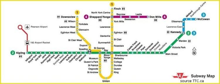
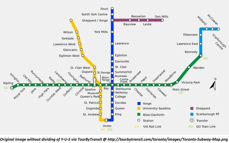
The Yonge portion of the line runs under Yonge Street from its northeastern terminus at Finch Avenue to Union Station, connecting with Line 4 Sheppard at Sheppard–Yonge and Line 2 Bloor–Danforth at Bloor–Yonge. It continues along University Avenue to St. George and Spadina, which both connect to Line 2. It runs for two stations along Spadina Avenue before continuing along the Cedarvale and Nordheimer ravines to Allen Road. Its northwestern terminus, Downsview, is located at the intersection between Sheppard Avenue and Allen Road.
Name
The line's name has been changed as it was extended. Following its opening in 1954, it was called "the subway" (Yonge subway is its retronym). In 1963, it was extended along University Avenue to St. George station and renamed the "Yonge–University Line". Briefly in 1966, the Yonge–University subway ran in two branches: one west along Bloor to Keele (Yonge–University–Bloor), the other east along Bloor and Danforth to Woodbine (Yonge–University–Danforth) via Bay Lower station.
In 1978, the "Spadina" section was opened and the line became the "Yonge–University–Spadina Line" (YUS). Although only two stations are on Spadina Road, a larger portion of the line was planned to follow the Spadina Expressway. The built portion part of the expressway was renamed William R. Allen Road. The subway also had an additional internal route number; route 602.
Unofficially, subway lines were already numbered, but in October 2013, the TTC announced plans to publicly display line numbers to help riders to navigate the system. The Yonge–University line would be numbered as Line 1.
This process began in March 2014, when new numerical signs referring to subway routes as Line 1 for the Yonge–University line and Line 2 for the Bloor–Danforth line were phased in on signs and maps at Bloor–Yonge and St. George stations. The line numbers have been rolled out on rapid transit maps at all subway stations in the system. Similarly, the reconfigured announcements on the line's new Toronto Rocket subway trains between 2015 and 2016 also adopted the new numerical system for the interchange station announcements, such as "Change for Line 2" and "Change for Line 4" respectively replacing "This station connects with the Bloor–Danforth subway" and "This station connects with the Sheppard subway". Its official name is 1 Yonge–University Subway. In 2015, the Spadina part was dropped from the name to become just Yonge–University again.
Early proposals
There were several early proposals to build a subway along or near Yonge Street, many of which involved running streetcars in a tunnel. Here are some of the proposals.
Construction
During World War II, workers travelling from their homes in "northern Toronto" (which would now be considered the downtown core) to the industrial areas to the east and west of the downtown area on Yonge seriously strained the existing road and streetcar networks. There was concern that the expected post-war boom in car ownership would choke the city with traffic. The scheme was first proposed by Toronto Transportation Commission in 1942 to relieve congestion which was delaying their bus and tram services. The TTC formed a Rapid Transit Department and studied various solutions between 1942 and 1945.
A plan was put to the voters on January 1, 1946. The plan had two parts. First, it featured a "rapid transit subway" operated with subway trains from Eglinton Avenue as far as College Street. The line would continue directly under Yonge and Front Streets to Union Station. Second would be a "surface car subway", diverting streetcar services off Queen and Dundas Street. This would run mostly along Queen Street, with each end angling north to reach Dundas Street west of Trinity Park and Gerrard Street at Pape Avenue. The route would run directly under Queen Street from University Avenue to Church Street, with the rest off-street. The vote was overwhelmingly in favour, and Toronto City Council approved construction four months later.
The plebiscite contained the condition that the federal government would subsidize 20% of the project. The federal Minister of Reconstruction, C.D. Howe, promised federal support in an October 3, 1945 letter. However, the funding fell through over a disagreement about the details of the employment arrangements. A scaled down proposal, about 20% smaller, was agreed to in its place. The work along Queen Street was abandoned temporarily, and the original $42.3 million ($560 million in 2012) was reduced to $28.9 million ($383 million in 2012) plus $3.5 million ($46.4 million in 2012) for rolling stock. After a two-year delay due to postwar labour shortages, construction on the new subway did not start until September 8, 1949. A total of 1.7 million cubic yards (1.3 million cubic metres) of material was removed and some 14,000 tons (12,700 metric tons) of reinforcing steel and 1.4 million bags of cement were put into place.
Service on the Yonge route would be handled by new rolling stock, and the TTC was particularly interested in the Chicago series 6000 cars, which used trucks, wheels, motors, and drive control technologies that had been developed and perfected on PCC streetcars. However, the United States was in the midst of the Korean War at the time, which had caused a substantial increase in metal prices, thus making the PCC cars too expensive. Instead, in November 1951, an order was placed with the Gloucester Railway Carriage and Wagon Company in England for 104 cars for $7,800,000 including spare parts.
Opening
After five years of construction, Ontario Premier Leslie Frost and Toronto Mayor Allan A. Lamport officially opened the 7.4-kilometre (4.6 mi) long Yonge subway on March 30, 1954. It was the first subway in Canada.
The original Yonge Street subway line went from Union subway station near the namesake railway station north to Eglinton Station. Dignitaries, including the premier and the mayor, rode the first train that morning, going north from the yards at Davisville Station, and then from Eglinton south along the entire line. The line was then opened to the public, and that day at 2:30 pm, the last streetcar made its final trip along the Yonge streetcar line.
Operations
Trains operated at average speeds of 20 miles per hour (32 km/h). The plan to operate two-car trains during off-peak hours was abandoned in favour of four-car trains, and six-car trains were standard during most periods, with some eight-car trains used during peak periods.
On February 28, 1963, an extension was added to curve north from Union Station, below University Avenue and Queen's Park to near Bloor Street, where it turned west to terminate at St. George and Bloor Street.
On June 23, 1969, the University subway service from St. George to Union stations was discontinued entirely after 9:45 p.m. on Mondays to Saturdays and all day on Sundays and Holidays. The 5B Avenue Road buses runs in place between Eglinton and Front Street whenever the University Subway did not operate, with side-jaunts to St. George station to capture passengers from the Bloor Subway. This arrangement remained in place until January 28, 1978 when the Spadina Subway opens north to Wilson Station.
On March 31, 1973, the line was extended north from Eglinton Station to York Mills Station, and on March 29, 1974 to Finch Station. These two extensions were part of the North Yonge Extension project, bringing the subway to North York.
Stations were also planned for Glencairn (between Eglinton and Lawrence, though another Glencairn Station would be built later on the Spadina section), Glen Echo (between Lawrence and York Mills) and Empress (between Sheppard and Finch, later opened as North York Centre Station).
On January 27, 1978, the Spadina segment of the line was opened, going from St. George Station, the north terminus of the University line, to Wilson Station. From St. George Station, the 9.9 km (6.2 mi) segment ran north and northwest to Eglinton Avenue and William R. Allen Road, then north along the median of the Allen Road to Wilson Avenue. This extension had been proposed as part of the Spadina Expressway, but when the expressway portion south of Eglinton Avenue was cancelled after massive protests, the subway was still built following the route through Cedarvale Ravine. Hence, it is called the Spadina subway line, though it follows Spadina Road for less than 2 km (1.2 mi).
On June 18, 1987, North York Centre Station was added between Sheppard and Finch stations.
On August 11, 1995 at 6:02 pm, the Russell Hill subway accident occurred as a southbound subway train heading toward Dupont Station crashed under Russell Hill Drive, killing three passengers and sending 30 to hospital. This accident prompted the Toronto Transit Commission to review its practices and put resources into safety.
On March 31, 1996, the Spadina segment of the line was extended 2 km (1.2 mi) from Wilson Station north to the new Downsview Station, where there were bus bays for connections to surface routes. At the time, a newly elected provincial Progressive Conservative government cancelled its share of funding that would have extended this route northward to York University and Steeles Avenue. However, this extension would later be constructed with a scheduled opening in late 2017. (See Toronto–York Spadina Subway Extension.)
As of November 17, 2016, with the Presto fare gates installed at Eglinton station, all of the stations along this line are Presto-enabled.
Toronto–York Spadina Subway Extension
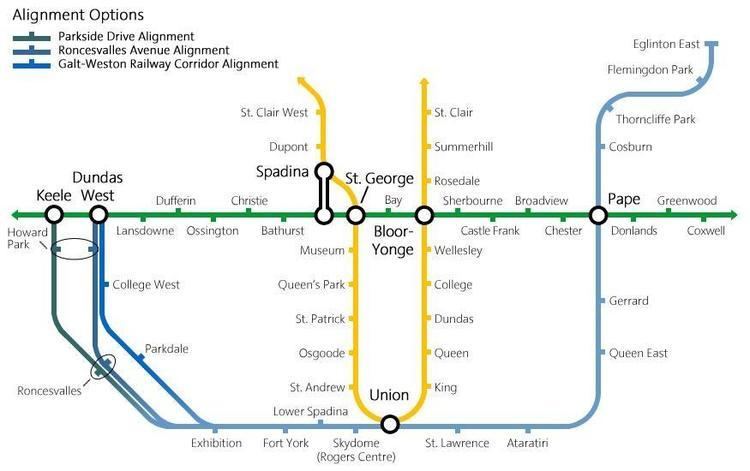
The Toronto–York Spadina Subway Extension (TYSSE) is an extension of the western portion of Line 1 from Downsview Station northwest via York University to the Vaughan Metropolitan Centre at Jane Street and Highway 7 in the city of Vaughan. Six new stations are planned along the 8.6 km (5.3 mi) route, with 6.2 km (3.9 mi) in the City of Toronto and 2.4 km (1.5 mi) in York Region. Service on the extension is estimated to begin in December 2017.
Approximately 2,900 new parking spaces will be built at three stations along the extension, in order to encourage commuters to use the subway system. Pioneer Village Station will have the most at 1,900 spaces, while Highway 407 Station will have 600 spaces, and Finch West Station will have 400 parking spaces. The subway right of way extends to Portage Parkway for potential future expansion.
Background
A Spadina extension into Vaughan had been suggested as early as 1988, when Lorna Jackson campaigned during the Vaughan municipal elections to extend the subway system to the proposed Highway 407 corridor.
Greg Sorbara, former deputy premier of Ontario and finance minister, was a key promoter of the TYSSE to the York University and into York Region, which was his riding. In his memoirs, he said that "it would not only be great for the people in the region, but also for my political prospects." Former Toronto mayor David Miller was initially not enthusiastic about the extension, about whom Sorbara said: "He should have been thrilled at the prospect of the province providing $670 million for more subway infrastructure, regardless of where it went."
Temporary busway
In 2003, a temporary busway was planned between Downsview Station and the campus, but was opposed by the university, which felt it would lessen government willingness to extend the subway. After numerous delays, construction on the York University Busway started on July 25, 2008, with a short section of the busway opened on September 6, 2009 and the remainder opened on November 20, 2009.
Construction
The estimated cost of was $2.09 billion in 2006 dollars, which will have escalated to $2.63 billion considering costs at the year of occurrence. The Province of Ontario has deposited $870 million into the Move Ontario Trust. The federal government has committed $697 million, but only released $75 million at the start of its fall 2006 election campaign. The City of Toronto and the Regional Municipality of York have committed to fund one-third of total project costs, with Toronto will contributing $526 million and York Region contributing $352 million.
The first construction contract was awarded on February 27, 2008. Construction commenced in July 2008 with the relocation of sewers.
The TTC purchased two tunnel boring machines in late 2010 from LOVAT Inc. (since then a part of Caterpillar Inc.) for $58.4 million to dig tunnels on this extension, and two more boring machines were delivered in early 2011. Tunnel boring for the extension began on June 17, 2011 and was completed on November 8, 2013.
By 2015, the project had encountered several problems such as frequently changing station design plans, project management problems resulting in the dismissal of two TTC managers, poor performance by some contractors, death of a worker at the York University station site and harsh winter weather.
After the extension was found to be over-budget in March 2015, the Toronto City Council approved an additional $150 million in funding, with $90 million from Toronto and $60 million from York Region. The TTC subsequently signed a contract with Bechtel, worth up to $80 million, to assume management of the extension. This bypassed the tendering process usually used to hire contractors.
During construction, costs grew from the original $2.6 billion to about $3.2 billion by January 2016.
Criticism
The extension north of Steeles Avenue has been criticized in the press for several reasons. The TTC had intended to extend the subway as far as York University, with a vast bus terminal complex at the future Pioneer Village Station. However, provincial funding hinged on the line crossing the municipal border. The area around the future Vaughan Metropolitan Centre Station is occupied by big-box stores and highways, and lacks the dense development that surrounds most other subway stations. In addition, the 407 Transitway station is being built within vacant land, across the street from Beechwood Cemetery.
Vaughan plans to use the subway extension to spur the development of a transit-oriented city centre at Vaughan Metropolitan Centre Station. Vaughan Councillor Alan Shefman stated the new city centre will eventually create the density to justify a subway. However, the Sheppard subway shows that while a subway may spur development, that development may not translate into a high subway ridership. As Royson James pointed out in the Toronto Star, commuter destinations may be scattered throughout the Greater Toronto Area where public transit is inconvenient to use.
Although a station is planned for the 407 Transitway, most GO Transit buses will terminate at Black Creek Pioneer Village Station, so that commuters do not have to pay an additional TTC fare to reach York University. The TTC announced that it will incorporate a system in which GO Transit users do not have to pay an extra fare to use the subway to arrive at York University Station from the 407 Transitway.
Operating costs
In 2008, the TTC, York Region and the City of Toronto signed a memo of understanding to allocate TYSSE costs and revenues for the portion of the line in Vaughan. According to this MOU:
The TTC will be responsible for the full operating costs of the Spadina Subway extension from Downsview to the Vaughan Corporate Centre and receive all revenue from the Project (passenger revenue, commuter parking, advertising, retail leasing), with the exception of the operating costs and revenues for bus terminals and passenger pickup and drop off facilities located within York Region, which shall be maintained and operated by York Region.According to a TTC forecast reported by transit advocate Steve Munro in early 2015, the TTC's annual operating costs for the entire TYSSE will be $33.7 million or $14.2 million net of revenue. This would produce a 58% cost recovery compared to 70% for the TTC system as a whole. These costs, including those for the portion in Vaughan, will be covered by the TTC and the City of Toronto. In 2016, the expected net cost to run the extension was revised to $30 million.
Future expansion: Yonge North
The Yonge North Subway Extension is a proposal to extend the Yonge Street portion of Line 1 north of Finch Station to Richmond Hill in York Region. Six new stops would be added at Cummer/Drewry, Steeles, Clark, Royal Orchard, Langstaff/Longbridge and the Richmond Hill Centre Terminal of Viva bus rapid transit. This $4-billion proposal would take 10 years to build and would replace many of the 2,500 buses per day that run along the route. Ridership on the proposed extension is estimated at 165,000 per day. The extension would be 7.4 km long. York Region estimates that the extension will help to create 31,000 jobs, and that the extension would carry 58 million riders annually by 2031.
History
On June 15, 2007, the Ontario government announced plans to fund this extension as part of a network of rapid transit growth called MoveOntario 2020.
In April 2009, the Environmental Assessment for the Yonge North Subway Extension was approved.
In November 2014, an addendum to the Environmental Assessment was approved to include an underground train storage facility and surface facilities.
By 2016, the province had committed to fund 15 per cent of the preliminary engineering and design for the project.
On June 2, 2016, the provincial government gave $55 million to Metrolinx in order to work with the TTC and the York Region on a detailed plan for the subway extension.
Capacity constraints
Toronto council approved the plan in principle in January 2009 provided there were upgrades to the existing line to support the additional ridership from York Region. Specifically, Toronto politicians say that the Yonge line does not have the capacity to support an extension to Richmond Hill until a separate relief line is built between Pape and Osgoode stations. In March 2016, the mayor's office said that SmartTrack and automatic train control may also be required.
In March 2016, York Region officials said that SmartTrack, electrified GO service, the Spadina subway extension and automatic train control will be implemented within a decade, and that these would be sufficient to support the extra ridership of an extension to Richmond Hill. Thus, the deputy mayor of Richmond Hill wanted to start construction of the extension by 2019. Vaughan politicians and officials are basing their case on a Metrolinx report from June 2015. The report indicates the Yonge line would have a capacity of 36,000 pphpd in 2021 with automatic train control. Demand is 31,200 pphpd in 2015 plus 6,600 growth by 2031 plus 2,400 for the extension north of Steeles giving a total demand of 40,200 pphpd. The TYSSE would divert 1,300 pphpd and Regional Express Rail would divert another 4,200 leaving a demand of 34,700 pphpd and 1,300 pphpd in excess capacity. (However, as of April 2016, Metrolinx has no immediate plans to provide electrified GO service on the Richmond Hill line.) Transit advocate Steve Munro says that, given the Metrolinx analysis, the line would be at 96% capacity in the peak hour and, because this is the peak hour average, there would be some overcrowding due to variations over the hour.
In June 2016, TTC spokesperson Brad Ross said that the ridership on the Yonge line is regularly 24,000 passengers per hour during the morning rush hours, approaching the line's capacity of 25,500. Automatic train control would increase the line's capacity to over 32,000 riders per hour but that would still not be enough to support the increased ridership from the extension. The TTC would need the completion of the relief line and SmartTrack in order to support the extra riders from York Region. (Note that the TTC and the Metrolinx report disagree as to the estimated capacity of the Yonge line after the implementation of automatic train control.)
In the morning rush hours, southbound trains on the Yonge line usually reach capacity between York Mills and Eglinton stations.
Criticism
GO Transit's long-term plan also calls for all-day service on its Richmond Hill line that would run express trains every 15 minutes between its Langstaff Station adjacent to the Richmond Hill Centre terminal, and Union Station in downtown Toronto, calling into question the additional need for a subway extension.
As of April 2016, Metrolinx had no plans to electrify the Richmond Hill line which would require $1 billion for flood mitigation. Planned service improvements are every 15–30 minutes but only in the peak period.
Busway
Given the wait for the Richmond Hill extension, there were plans to have Viva Bus Rapid Transit bus lanes along Yonge Street from Finch Avenue to Highway 7. However, by April 2014, the plans were revised to run the busway from Highway 7 (at the proposed terminal of the North Yonge Subway Extension) north to Newmarket with some portions of the route operating in mixed traffic through Richmond Hill. The expected completion date of the revised busway is 2018.
A local group in York Region was lobbying for the cancellation of the planned busway along this route, which would have been a part of York Region's Viva bus rapid transit. The group was concerned about a loss of treed boulevards and private property when widening Yonge Street for bus lanes through Thornhill south of Highway 7.
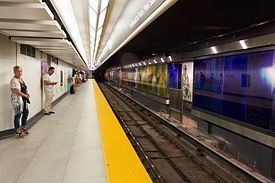
Stations
The line forms a rough U-shape. Its western leg starts at the northern terminus at Downsview Station, at Sheppard Avenue and Allen Road. The line follows the Allen Road, which becomes a short expressway with the subway line travelling in its median for 6 km (3.7 mi). Continuing southeast below the Cedarvale and Nordheimer Ravines, it turns south under a short stretch of Spadina Road.
After sharing Line 2 Bloor–Danforth's Spadina and St. George stations, it turns south again under Queen's Park, passing to one side of the Ontario Legislature, and running the full length of University Avenue beyond. It turns east onto Front Street to serve Union Station, Toronto's main railway terminus, and then north.
The eastern leg runs straight up Yonge Street for 16 km (9.9 mi), crossing Line 2 Bloor–Danforth again at Bloor–Yonge and Line 4 Sheppard at Sheppard–Yonge, before reaching its northern terminus at Finch Station. A roughed-in station exists below Queen Station for the proposed Queen streetcar subway. This section often suffers from severe overcrowding during peak times, especially in the area immediately south of Bloor-Yonge station.
The line is mostly underground, but has several surface or elevated sections between Downsview and Eglinton West, and between Bloor and Eglinton; some portions of the section between Bloor and Eglinton were originally open and have since been covered over to permit other uses above the tracks. Sections between Bloor–Yonge and the track short of Summerhill, and between St. Clair and Eglinton remain in their original open state. Between Summerhill and St. Clair, the track was built in open cut, but has since been covered over. Evidence of this can be seen in the tunnel: there are no columns or walls between tracks, and ballast and drainage ditches are present, something not seen in the rest of the subway system. There are also tree stumps and the stubs of lamp posts in the tunnel. There are also clues outdoors: seemingly useless railings along the sides of a nearby street, which was once on an exposed bridge, and empty lots following the trains' right-of-way marked with signs warning heavy vehicles and equipment to keep off because they might fall through to the columnless tunnel below.
Most of the tunnel was constructed by a cut-and-cover method, but some was bored, as noted below. All stations, whether by transfer or fare-paid terminal, connect to surface TTC bus and/or streetcar routes. Other surface and train connections are noted below.
As of late 2014, 18 stations have elevators for wheelchair and stroller access.
The preferred alignment and placement for four stations for the extension beyond Downsview Station to serve York University were finalized in September 2005. Six stations are planned: the tentative name for the new terminus in the Vaughan Metropolitan Centre is "Vaughan Centre" based on the precedent set by North York Centre and Scarborough Centre, with intermediate stations called "Highway 407", "Pioneer Village", "York University", "Finch West", and "Downsview Park", with plans to rename Downsview Station "Sheppard West". This extension will replace the portion of York Region Transit's Viva Orange bus rapid transit line that covers the Downsview–York University route.
Design
The original design of the oldest stations in the subway system, which are on the Yonge line (from Union to Eglinton), are mainly utilitarian and characterized by vitreous marble wall tiles and the use of the Toronto Subway font for station names. Eglinton Station is the only station to retain this wall treatment, though Queen Station retains a narrow band of original blue Vitrolite tiles near the ceiling at platform.
The design of the stations on the University line was mainly utilitarian and this style (sometimes referred to as “bathroom modern”) was later used for the Bloor–Danforth line as well. Queen's Park and St. Patrick stations have circular and semi-circular cross-sections, because they are constructed in bored tunnels. Museum station was renovated to have columns resemble artifacts found in the nearby Royal Ontario Museum.
Lawrence, York Mills, Sheppard, and Finch Stations are similar to each other in design, but have different colour schemes: Lawrence is red and cream, York Mills is light and dark green, Sheppard is yellow and dark blue, and Finch is light grey, medium grey, and dark grey.
The Spadina line has art and architecture that is unique for each station. The art installed in Glencairn and Yorkdale stations has been removed, as the former's art had faded and the latter was too costly to operate.
North York Centre station is an infill station. Its design is different from the other stations in the earlier North Yonge extension.
Downsview, which was opened in 1996, is the newest station on this line. It has art and architecture that is different from the earlier Spadina line stations.
The Spadina line extension north to Vaughan Metropolitan Centre will feature art and architecture from notable artists and architects.
Operation hours and frequency
As with other TTC subway lines, Line 1 operates most of the day, and is generally closed between 2:00 a.m. and 6:00 a.m. EST on weekdays and Saturdays, and 2 a.m. to 8 a.m. on Sunday. Trains arrive at stations 2–3 minutes during peak periods and 4–5 minutes during off-peak periods. There is limited service (every 5 minutes) north of St. Clair West Station from 6:00 am to 9:00 am Monday to Friday.
Overnight service on the Yonge segment of the line is provided by 320 Yonge Blue Night from Queens Quay to Steeles with headways of 3 to 15 minutes. The University segment does not have an overnight service.
Rolling stock
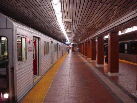
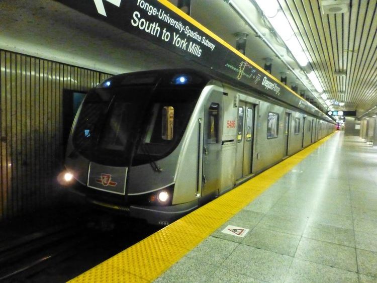
The line is solely operated with the TTC's newer Toronto Rocket (TR) subway trains, which are based on Bombardier's Movia family of trains. Unlike other trains in the Toronto subway rolling stock, the TR trains have a "six-car fixed" articulated configuration with full-open gangways, allowing passengers to walk freely from one end to the other. The TR trains were scheduled for delivery starting between late 2009 and early 2010, but was delayed until late 2010 due to production problems. They entered revenue service on this line on July 21, 2011, replacing the older H5 and the T1 series trains, which had been used on this line. (The T1 series trains, which used to operate on this line, were transferred over to Line 2 Bloor–Danforth where they replaced the older H4 and H6 series trains).
From the line's opening in 1954 until 1990, it was operated with G-series cars, and was also served with a mix of M1 and H1/H2/H4 subway cars between 1965 and 1999.
Automatic train control
The TTC is converting its block signal system to automatic train control on Line 1 Yonge–University. With ATC, the TTC will be able to reduce the headway between trains on Line 1 from 2.5 minutes to 1 minute and 55 seconds during rush hours, and allow a 25 per cent increase in the number of trains operating on Line 1. ATC will be introduced to Line 1 in phases. The first phase is to activate ATC between Spadina and Wilson stations by fall 2017. With the opening of the Toronto–York Spadina Subway Extension in December 2017, ATC will be extended north from Wilson Station to Vaughan Metropolitan Centre. The entire line would be converted to ATC in 2019.