
Country Switzerland District Viamala Elevation 1,624 m Postal code 7438 | Canton Graubünden SFOS number 3691 Population 78 (31 Dec 2008) Local time Sunday 1:21 AM | |
 | ||
Website www.hinterrhein.ch SFSO statistics Weather 2°C, Wind N at 14 km/h, 48% Humidity | ||
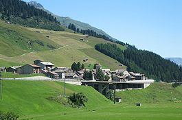
Hinterrhein (Romansh: Valragn) is a municipality in the Viamala Region in the Swiss canton of Graubünden. The town is located near the start of the river Hinterrhein/Rein Posteriur, one of the two initial tributaries of the Rhine.
Contents
- Map of Hinterrhein Switzerland
- History
- Geography
- Demographics
- Languages
- Heritage sites of national significance
- Climate
- References
Map of Hinterrhein, Switzerland
History
Hinterrhein is first mentioned in 1219 as de Reno.
Geography
Hinterrhein has an area, as of 2006, of 48.4 km2 (18.7 sq mi). Of this area, 22.7% is used for agricultural purposes, while 7.6% is forested. Of the rest of the land, 1.2% is settled (buildings or roads) and the remainder (68.5%) is non-productive (rivers, glaciers or mountains).
Before 2017, the municipality was located in the Rheinwald sub-district, of the Hinterrhine district, after 2017 it was part of the Viamala Region. It is a haufendorf (an irregular, unplanned and quite closely packed village, built around a central square) located on the northern portal of the San Bernardino tunnel.
Demographics
Hinterrhein has a population (as of 31 December 2015) of 66. As of 2008, 6.4% of the population was made up of foreign nationals. Over the last 10 years the population has stayed stable.
As of 2000, the gender distribution of the population was 57.7% male and 42.3% female. The age distribution, as of 2000, in Hinterrhein is; 9 people or 8.6% of the population are between 0 and 9 years old. 2 people or 1.9% are 10 to 14, and 6 people or 5.7% are 15 to 19. Of the adult population, 14 people or 13.3% of the population are between 20 and 29 years old. 19 people or 18.1% are 30 to 39, 19 people or 18.1% are 40 to 49, and 11 people or 10.5% are 50 to 59. The senior population distribution is 14 people or 13.3% of the population are between 60 and 69 years old, 9 people or 8.6% are 70 to 79, there are 2 people or 1.9% who are 80 to 89.
In the 2007 federal election the most popular party was the SVP which received 76.6% of the vote. The next three most popular parties were the FDP (12.3%), the SPS (6.5%) and the CVP (4.5%).
In Hinterrhein about 44.8% of the population (between age 25-64) have completed either non-mandatory upper secondary education or additional higher education (either university or a Fachhochschule).
Hinterrhein has an unemployment rate of 0.36%. As of 2005, there were 28 people employed in the primary economic sector and about 12 businesses involved in this sector. 2 people are employed in the secondary sector and there is 1 business in this sector. 11 people are employed in the tertiary sector, with 4 businesses in this sector.
The historical population is given in the following table:
Languages
Most of the population (as of 2000) speaks German (75.2%), with Italian being second most common (14.3%) and Portuguese being third ( 5.7%).
Heritage sites of national significance
The Alte Landbrücke (Old Bridge) is listed as a Swiss heritage sites of national significance.
Climate
Between 1961 and 1990 Hinterrhein had an average of 121.4 days of rain per year and on average received 1,469 mm (57.8 in) of precipitation. The wettest month was May during which time Hinterrhein received an average of 194 mm (7.6 in) of precipitation. During this month there was precipitation for an average of 14.2 days. The driest month of the year was February with an average of 45 mm (1.8 in) of precipitation over 14.2 days.