
Population 13,520 (2011 census) Postcode(s) 2040 Founded 1846 | Established 1846 Area 4.565 km² Postal code 2040 | |
 | ||
Location 5 km (3 mi) west of Sydney CBD | ||
Leichhardt is a suburb in the Inner West of Sydney, in the state of New South Wales, Australia. Leichhardt is located 5 kilometres west of the Sydney central business district (CBD) and is the administrative centre for the local government area (LGA) of the Inner West Council. The suburb is bordered by Haberfield to the west, Annandale to the east, Lilyfield to the north and Petersham, Lewisham and Stanmore to the south.
Contents
- Map of Leichhardt NSW 2040 Australia
- Aboriginal anthropology
- European settlement
- Commercial area
- Transport
- Houses
- Churches and schools
- Landmarks
- Parks and recreation
- Culture
- Demographics
- Politics
- Notable residents
- References
Map of Leichhardt NSW 2040, Australia
Leichhardt contains a mix of residential and commercial developments and is best known as Sydney's "Little Italy". Leichhardt residents and businesses live and work next to the Sydney CBD.
Aboriginal anthropology
Leichhardt was once an area broadly inhabited by the Wangal band of the Dharug (Eora) language group. The 'Eora people' was the name given to coastal Aborigines around Sydney – Eora means from this place – local Aboriginal people used this word to describe to Europeans where they came from, and in time the term became used to define Aboriginal people themselves. Wangal country was known as 'wanne' and it originally extended from the suburbs of Balmain and Birchgrove in the east to Silverwater and Auburn in the west. It is unclear how many people were in the tribe, some research indicates in the broader Sydney region there was between 8000 – 10000 indigenous people, migration over the seasons and violence between tribes would alter this number at different periods. The northern boundary was the Parramatta River. Neighbouring Darug bands were the Cadigal to the east, the Wallumattagal on the northern shore of the Parramatta River and the Bediagal to the south.
European settlement
Leichhardt is named after the Prussian explorer Ludwig Leichhardt, who in the 1840s was feted for his 4,800 km (c. 3000 mi) expedition in search of an overland route from southern Queensland to Port Essington, a British settlement on the far northern coast of Australia (some 300 km to the north of the modern city of Darwin). In 1848, he famously vanished without trace on his attempt to cross the continent from the Darling Downs to the Swan River Colony on the Western Australia coast.
Leichhardt was proclaimed a municipality in 1871. In 1949, it was merged with the municipalities of Annandale and Balmain. In 1967, the municipal boundary was altered to include Glebe and parts of Camperdown. In 2003, the municipal boundary was again changed, to exclude Glebe and Forest Lodge, which are now part of the City of Sydney.
Commercial area
The main commercial area in Leichhardt is located on Norton Street, north of Parramatta Road and parallel to Balmain Road. The Norton Street commercial area contains a mix of residential buildings, restaurants (Italian and others), cafés, eateries and individual retail outlets, including several bookstores and grocery shops. There are also hotels, a Palace Cinema and two of the suburb's two shopping centres – MarketPlace Leichhardt and Norton Plaza. Commercial developments are also found along the length of Parramatta Road.
The Italian Forum, located just off Norton Street, is notable for its design which seeks to emulate the feel of a Mediterranean town piazza. A pedestrian-only central courtyard featuring outdoors and indoors restaurant dining as well as Leichhardt Library is surrounded by small shops and boutiques on the level above, and all overlooked by residential apartments. The second shopping centre, MarketPlace Leichhardt (formerly Market Town), is located towards Haberfield on the corner of Marion and Flood Streets. MarketPlace Leichhardt has free car parking and is home to Woolworths, Aldi, Target and over 60 specialty stores. The centre recently celebrated its 40th birthday milestone of being in the heart of Leichhardt.
Transport
Leichhardt can be accessed by several main roads including Parramatta Road, Norton Street, Balmain Road, Marion Street and Catherine Street. The City West Link Road runs along the northern border of Leichhardt and is a major arterial road, which is part of the A4 and crosses the Anzac Bridge to the CBD.
Leichhardt is well serviced by Sydney Buses through city and cross regional services. Leichhardt Bus Depot is located on the corner of William and Derbyshire Street. The following list provides the bus routes in Leichhardt:
The southern portion of Leichhardt is serviced by trains at the nearby Petersham railway station, on the Airport, Inner West & South Line. The station is an eight-minute walk from Norton St, along Railway St.
The western and northern portions of Leichhardt are serviced by trams (light rail) on the Dulwich Hill Line of Sydney's light rail network. Leichhardt North lies on the northern border with Lilyfield, adjacent to the City West Link. Hawthorne, serving the north-west of the suburb, and Marion, near Marion Street, are on the western border with Haberfield. Taverners Hill is adjacent to Parramatta Road and lies in the south-west corner of the suburb.
Leichhardt was served by trams from Sydney's former network from 1887 to the 1950s. The Annandale Line ran down Norton Street. The current bus depot at the top of William Street was a 12 road depot, designed to serve a number of planned lines that were never built. Instead, it was used to stored surplus trams in the off peak period, and was rebuilt as the Government Bus Workshops in 1937. A small spur of track remained and was later used by tour trams going through the depot yard nearest Pioneer Park. It is now Sydney Buses South Western Headquarters.
Houses
Being situated close to the city, Leichhardt is an area for great capital growth as it very central and has a lot to offer, so housing is not very cheap and is a much sought after. The architecture in Leichhardt ranges from Victorian single fronted brick homes to modern new homes and apartment blocks.
Churches and schools
Leichhardt has a number of primary schools and one secondary school.
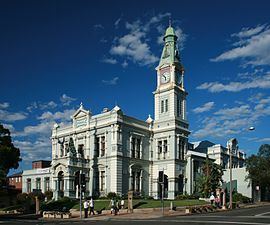
Landmarks
The following buildings are listed on the Register of the National Estate:
Parks and recreation
Culture
Leichhardt is home to many creative industry workers and is known for its colourful and inventive mural art, such as the panorama at the Renwick Lane and at the Hawthorne Canal Railway Underpass. Leichhardt has access to many art and cultural organisations. Commercial galleries are found throughout the area and Boomali Gallery, the Aboriginal Arts Organisation is situated in Flood Street in Leichhardt.
The Italian community has a wealth of social and cultural organisations located in Leichhardt, and work is underway everyday to develop the Italian Forum Cultural Centre. Co.As.It. is one of them and they provide a range of culturally and linguistically appropriate services to enhance the quality of life of the community and to promote the Italian language and culture in New South Wales.
Leichhardt is the yearly host of the Italian Festa on Norton Street where local traffic is temporarily closed on Norton and neighbouring streets transforming surroundings into a huge European style outdoor café, celebrating Leichhardt's cultural diversity with an International Food Fair, gift stalls, community expos and live entertainment throughout the day. Leichhardt is also known for its café culture with cafés in abundance. The oldest café in the area is Café Sport, which is located on Norton Street.
Demographics
According to the 2007 census, Leichhardt had a population of 12,248 people. It did not have the same level of high density housing found in its neighbours Haberfield and Annandale. Approximately one third of dwellings were separate density housing houses with 22% apartments and 36% terraces, semis or townhouses. 63.7% of persons usually resident in Leichhardt stated they were born in Australia. Other common responses within the area were – England 4.8%, Italy 4.4%, New Zealand 3.1%, Greece 0.7% and Ireland 0.6%. English was stated as the only language spoken at home by 72.6% of persons usually resident in Leichhardt. The most common languages other than English spoken at home were – Italian 7.2%, Spanish 1.7%, Greek 1.6%, Cantonese 0.9% and Portuguese 0.7%. Catholicism is the primary religion in the area. However, marriage in the area is lower by both Sydney and Australia standards. The average age of people in the suburb was similar to the rest of Sydney (35) and a lower percentage of people owned their homes outright (22.4%) than those paying them off (30.7%). Average loan repayments ($2200 per month) were much higher than the national figure ($1300).
Since the middle of the 20th century, Leichhardt has been a centre for the Italian community, reflected in the many Italian-owned businesses in the area. Although it has become less distinctively Italian with the increasing gentrification of the suburb and movement of families to suburbs with larger blocks of land, its Italian character is still palpable, particularly in the popular restaurants and cafés of its main street, Norton Street. Many residents moved to suburbs further away from Sydney as the city has expanded and larger housing blocks became available.