
Population 7,702 (2011 census) Postal code 2048 | Postcode(s) 2048 Area 120 ha Local time Sunday 11:40 AM | |
 | ||
Weather 26°C, Wind SE at 6 km/h, 65% Humidity | ||
Stanmore is a suburb in the Inner West of Sydney, in New South Wales, Australia 5.5 kilometres inner-west of the Sydney central business district. It is part of the local government area of Inner West Council.
Contents
- Map of Stanmore NSW 2048 Australia
- History
- Commercial area and transport
- Schools
- Sport and recreation
- Churches
- Notable residents
- References
Map of Stanmore NSW 2048, Australia
History
Stanmore was named by a prosperous saddler, John Jones, who purchased land in 1835 where Newington College now stands and called it the Stanmore Estate. Jones named it after his birthplace of Stanmore,now a north west suburb of London. Land in the present Stanmore area was first allocated to colonial officers by Governor Phillip between 1793 and 1810. Thomas Rowley owned Kingston Farm which occupied the eastern half of Stanmore and much of Newtown, and a portion of George Johnston's Annandale estate covered the area south of Parramatta Road containing Annandale House built in 1799 on the hill between Macaulay and Albany Roads. It was from here where Johnston marched with his troops to Castle Hill on 5 March 1804 to quell the convict revolt and where he rode on 26 January 1808 to arrest Governor Bligh during the Rum Rebellion. The first Norfolk pines on the Australian mainland were planted along the line of Percival Road, leading to Parramatta Road by Lt Colonel George Johnston.
Stanmore Road was constructed in 1835 and early development occurred in this area. In 1855, the railway divided Stanmore into areas known as North and West Kingston north of the railway, and South Kingston south of the railway. The Kingston Farm had been sold to James Holt in 1835, and North Kingston was subdivided in 1854. South Kingston (between the railway and Stanmore Road) was slowly subdivided from 1857 with isolated large houses built between 1860 and 1870. It was not until the late 19th century that the name Stanmore came into more regular use, replacing Kingston. Municipal boundaries established in 1861 and 1871 placed most of Stanmore into the Municipality of Petersham, with the area south of Stanmore Rd placed into the Municipality of Marrickville. In 1878, Stanmore railway station was established and the streets west of Percival Road were laid out. More intensive development subsequently occurred in this area and the name Stanmore slowly moved northwards from Stanmore to Parramatta Roads. Stanmore became a desirable location, booming in the 1880s and 1890s with the opening of Newington College and the Percival Road shopping area. The naming of streets after English colonies between Derby and Stafford streets reflected the English values of the time. The final subdivision of Johnston's South Annandale estate took place in 1905, and building was not completed until 1916-1918. Annandale House was demolished in 1905, and Weekley Park was established on land donated by the Johnston family.
A small amount of light industry was established in the early 1920s in the area close to Parramatta Rd, including H Small and Co, a chocolate maker opening in 1928, and Starkeys Cordials. Both establishments have now closed with their premises converted into offices and apartments.
Commercial area and transport
Stanmore railway station is on the Airport, Inner West & South Line of the Sydney Trains network. Stanmore has a small shopping centre beside Stanmore railway station. Commercial developments also run along the length of Parramatta Road.
Schools
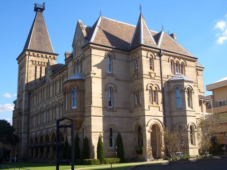
Stanmore is home to Newington College, an independent GPS boys school, the state primary Stanmore Public School and Saint Michael's Catholic Primary.
Both Newington and Stanmore Public are of heritage significance and the main buildings of distinguished designs. Of Newington's design by Thomas Rowe the architectural historian Morton Herman said:
Of Stanmore Public School's design by Blackmann and Parkes Herman said:
Sport and recreation
Apart from the private facilities at Newington College, sporting and recreation facilities in Stanmore are limited to a handful of small parks and playgrounds including Weekley Park, Crammond Park and Montague Gardens. Stanmore does lend its name, however, to the Stanmore Hawks soccer club which plays in the NSW State League Division One, the third tier of senior soccer in Sydney.