
Footnotes Coordinates | ||
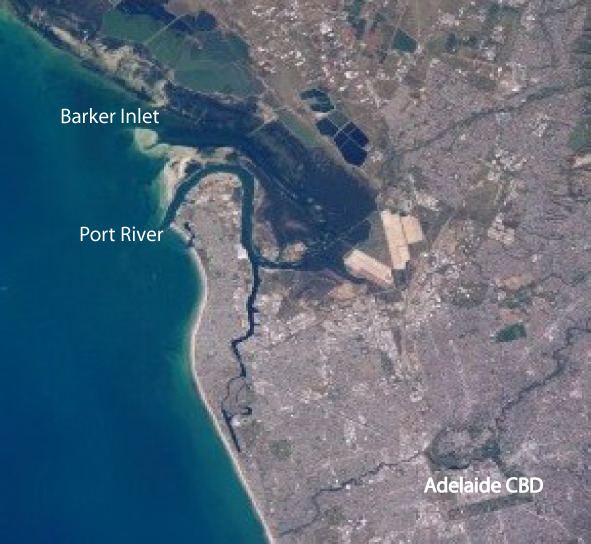 | ||
The Lefevre Peninsula is a peninsula located in the Australian state of South Australia located about 15 kilometres (9.3 mi) northwest of the Adelaide city centre. It is a narrow sand spit of about 30 square kilometres running north from its connection to the mainland.
Contents
- Map of Lefevre Peninsula Taperoo SA 5017 Australia
- Location and extent
- Description
- Naming
- European use
- Governance
- References
Map of Lefevre Peninsula, Taperoo SA 5017, Australia
Location and extent
Lefevre Peninsula located on the east coast of Gulf St Vincent about 15 kilometres (9.3 mi) north-west of the Adelaide city centre. The peninsula is bounded to the west by Gulf St Vincent and to the north and the east by the Port River. The southern boundary of the “topographical peninsula” has been determined by the Surveyor General of South Australia as being Recreation Road in the suburb of Semaphore Park as “an examination of old plans indicate that boats could have navigated the Port Adelaide River to approximately this point.”
Description
The western, Gulf St Vincent, coast of the peninsula consists of a continuous stretch of fine, white sand beaches. The eastern side is defined and separated from the mainland by the Barker Inlet and Port River. Torrens Island lies nearby to the east. To the east of the base of the peninsula is the suburb of Port Adelaide. Much of the peninsula has been developed, with residential areas extending inland from the western beaches, and heavy industries concentrated along the Port River waterfront on its eastern shore.
The peninsula has strong maritime associations due to its proximity to Port Adelaide, the Port River and Outer Harbor. Collins class submarines were built at the suburb of Osborne. Cement production also occurs on the peninsula at Birkenhead. In 1999, the Pelican Point Power Station was established at the northeastern tip of the peninsula adjacent to the Port River.
Lefevre Peninsula also contains several sailing clubs and golf clubs and the popular Semaphore Road foreshore and . The Outer Harbor Railway Line runs through the peninsula from Ethelton to Outer Harbor.
Naming
It was named by Governor John Hindmarsh on 3 June 1837 after Sir John George Shaw-Lefevre, who was one of South Australia's Colonisation Commissioners.
European use
European settlement commenced in the early 1840s. Before it was developed, much of the coastline was covered with mangroves. The land was extensively covered with bush, with such plants as wattle, sheoak and other native species. The peninsula now has a wind swept feel due to the clearance of these plants.
Governance
The Lefevre Peninsula is located within the local government area of the City of Port Adelaide Enfield, the state electoral districts of Lee and Port Adelaide and federal divisions of Hindmarsh and Port Adelaide.
The following suburbs are located on the Lefevre Peninsula: Birkenhead, Ethelton, Exeter, Glanville, Largs Bay, Largs North, New Port, North Haven, Osborne, Outer Harbor, Peterhead, Semaphore, the northern end of Semaphore Park, Semaphore South and Taperoo.