
Prominence 1,009 m Parent range Laramie Mountains | Elevation 3,132 m Mountain range Laramie Mountains | |
 | ||
Similar Medicine Bow Peak, Cloud Peak, Francs Peak, Gannett Peak, Wind River Peak | ||
Laramie peak summit wyoming thunder lightning storm
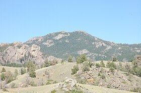
Laramie Peak Is the highest and most prominent peak in the Laramie Range of Wyoming. With a peak elevation of 10,276 feet (3,132 m), it is the only peak in the Laramie Range to exceed an elevation of 10,000 feet (3,000 m). It can be seen from great distances from both sides of the Laramie Range including from around 100 miles (160km) away at the top of the Scotts Bluff National Monument in Nebraska and in the Wyoming towns of Wheatland, Douglas, Rock River, and immediately outside of the cities of Laramie and Cheyenne.
Contents
- Laramie peak summit wyoming thunder lightning storm
- Map of Laramie Peak Wyoming 82201 USA
- Buffalo hunt 2016 laramie peak fire zone
- Name
- History
- Usage
- References
Map of Laramie Peak, Wyoming 82201, USA
Buffalo hunt 2016 laramie peak fire zone
Name
The mountain was named for Jacques La Ramee, a French-Canadian fur trader who lived in the area in the 1820s and who was found dead at the Laramie River.
History
Laramie Peak was an important landmark for the settlers on the Oregon Trail and the Mormon Trail. After reaching Scotts Bluff the top of the hill was visible at the horizon. For more than one week the hill guided the people on the track and signal the end of the relatively flat part of the way, reaching the Rocky Mountains
Mark Twain wrote 1871 in his book Roughing It about the hill: "We passed Fort Laramie in the night, and on the seventh morning out we found ourselves in the Black Hills, with Laramie Peak at our elbow (apparently) looming vast and solitary -- a deep, dark, rich indigo blue in hue, so portentously did the old colossus frown under his beetling brows of storm-cloud. He was thirty or forty miles away, in reality, but he only seemed removed a little beyond the low ridge at our right."
Usage
A trail starting at the Friend Park Campground leads over a distance of about 5 Miles to the top of the hill. It rises from 7200 feet elevation to 10200 feet. On top, several antennas, containers for transmitters and a helicopter platform are installed.