
Easiest route Hike, scramble First ascent 1873 Topo map USGS Temple Peak | Elevation 4,021 m Prominence 778 m | |
 | ||
Similar Francs Peak, Fremont Peak, Gannett Peak, Atna Peaks, Downs Mountain | ||
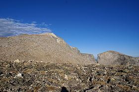
Wind River Peak (13,197 feet (4,022 m)) is the highest point in the southern end of the Wind River Range that is located in the U.S. state of Wyoming. The peak straddles the Continental Divide and is surrounded by National Forest lands. The west slopes are in the Bridger Wilderness of Bridger-Teton National Forest, while the east side is in the Popo Agie Wilderness of Shoshone National Forest. In a cirque on the northeast slopes of the peak lies Wind River Glacier.
Map of Wind River Peak, Wyoming 82520, USA
References
Wind River Peak Wikipedia(Text) CC BY-SA