 | ||
Restaurants Nomé Izakaya, Sushi One, Han Ba Tang, EAT BKK Thai Kitchen, JOONS Restaurant | ||
Lansing is a neighbourhood in the North York district of Toronto, Ontario, Canada. It is defined by the City of Toronto as Lansing-Westgate.
Contents
- Map of Lansing Toronto ON Canada
- The neighbourhood
- Households
- Demographics
- Neighbourhood highlights
- References
Map of Lansing, Toronto, ON, Canada
The neighbourhood
Formerly a much larger neighbourhood, the neighbourhood of Willowdale now occupies the area to the north. Lansing is now bordered by Yonge Street to the east, Highway 401 to the south, Bathurst Street to the west and Burnett Avenue to the north.
The neighbourhood can even be broken down further with Lansing occupying the northeastern quadrant and Armour Heights the southwest section.
Households
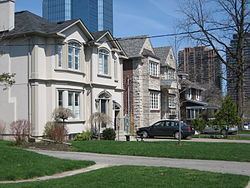
Homes in the neighbourhoods are largely owned and occupied by single families. Many mature pine trees in the neighbourhood and Don River effectively separate Armour Heights and Lansing providing peace and quite even though the neighbourhood is in close proximity to Toronto's Highway 401. Lansing is an interesting area filled with two distinct types of households. The first type are older couples, usually with adult children, living in post-war bungalows, the second, are younger wealthy families living in "rebuilds". The neighbourhood is currently undergoing significant construction as wealthy families buy more bungalows, tear them down and build two-million-dollar houses.
Demographics
According to the 2006 Canadian Census.
