
Surface area 9.60 km (3.71 sq mi) Area 9.6 km² Volume 0.22 km³ Outflow location Saane/Sarine | Primary outflows Saane/Sarine Max. length 13.5 km (8.4 mi) Surface elevation 677 m Catchment area 954 km² Length 13.5 km Inflow source Saane/Sarine | |
 | ||
Primary inflows | ||
Gopro paddling on the peaceful lake of gruy re switzerland
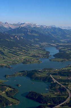
Lake of Gruyère (French: Lac de la Gruyère; German: Lac de la Gruyère or Greyerzersee) is a lake in the La Gruyère region of the Canton of Fribourg, Switzerland.
Contents
- Gopro paddling on the peaceful lake of gruy re switzerland
- Map of Lake of GruyC3A8re Switzerland
- References
Map of Lake of Gruy%C3%A8re, Switzerland
The reservoir was formed between the cities of Bulle and Fribourg, by building the Rossens Dam on the Sarine river in 1948. The arch dam has a height of 83 m and a crest length of 320 m. The reservoir filled in about four months after completion. The dam is operated by the Groupe E SA.
The remains of the castle of Pont (or Pont-en-Ogoz) and a chapel are located on the Ile d'Ogoz, one of the five islets in the lake.
The "Viaduc du Lac de Gruyère" of the A12 motorway was built in the 1970s. The bridge has a total length of 2043 m and crosses three valleys, including two arms of the lake.